The web Browser you are currently using is unsupported, and some features of this site may not work as intended. Please update to a modern browser such as Chrome, Firefox or Edge to experience all features Michigan.gov has to offer.
Iron Belle Trail
Iron Belle Trail
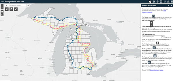
The Iron Belle Trail is the longest state-designated trail in the U.S., spanning over 2,000 miles from the western Upper Peninsula to Belle Isle in Detroit. The trail is currently more than 70% complete and connects over half of Michigan's counties.
This unique trail features two distinct routes: a biking route and a hiking route. The biking route travels along the eastern side of the state, using existing bike paths, lanes, and designated routes. Meanwhile, the hiking route follows the western side of the Lower Peninsula, incorporating sidewalks, trails and a significant portion of the North Country National Scenic Trail.
Trail activities
Biking
Hiking
Interactive and printable maps
-
Interactive GIS map
-
Printable PDF map
Zoom in to discover features such as trail segment length, trail width, surface type, available trailheads, parking lot information, nearby campgrounds, restrooms and more.
Overall map
Hiking routes
- Albion to Homer Bike Path - Concord - Falling Waters Trail
- Falling Waters Trail - Jackson - Lakeland Trail
- Lakeland Trail - Stockbridge - Pinckney - Border to Border Trail - Dexter
- Dexter - Border to Border Trail - Ann Arbor - Ypsilanti - Belleville
- Belleville - Border to Border Trail - Elizabeth Park - Grosse Isle - Ecorse
Biking routes
- Sterling Heights - Dodge Park Trail - Rochester Riverwalk - Rochester Hills
- Rochester Hills - Paint Creek Trail - Lake Orion - Oxford - Ortonville - Goodrich
- Goodrich - Grand Blanc - Grand Traverse Greenway - Flint River Trail - Flint
- Flint - Columbiaville - Otter Lake - Southern Links Trailway - Millington
- Millington - Vassar - Cass River Greenway - Frankenmuth - Harger Rail Trail - Saginaw - Zilwaukee
- Zilwaukee - Bay to Zilwaukee Railtrail - Bay City Bangor Railtrail - Bay City State Rec Area
- Bay City State Rec Area - Lake State RR Corridor - Fraser Township Trail - Pinconning
- Pinconning - Lake State RR Corridor - Omer - Au Gres
- Au Gres - Sunrise Side Pathway on US-23
- Sunrise Side Pathway on US-23 - Oscoda Community Trail - Iosco County River Pathway
- Iosco County River Pathway - County Road F-28 - Rose City - Consumers Energy - M-55 West Branch
- M-55 West Branch - St. Helen to Roscommon
- Roscommon - North Higgins Lake State Park - Old 27 - Grayling Area Community Pathway
- North Central State Trail - Cheboygan
- US Bicycle Route 10 on US-2, Mackinac County
- US Bicycle Route 10 on US-2 - Schoolcraft County - Manistique
- US Bicycle Route 10 on US-2 - Schoolcraft County - Delta County
- US Bicycle Route 10 on US-2 - Delta County - Gladstone - Escanaba
- US Bicycle Route 10 on US-2 - Menominee County - Powers
- US Bicycle Route 10 on US-2 - Dickinson County - Norway - Iron Mountain
- Iron Mountain - Crystal Falls - US-2 Bicycle Route, Iron County
- Iron River - US-2 Bicycle Route, Iron County
- US-2 Bicycle Route - Gogebic County
- US-2 Bicycle Route - Gogebic County - Wakefield
Both biking and biking routes
- Elizabeth Park - Grosse Isle - Ecorse - Belle Isle
- Belle Isle - Connor Creek Greenway - Sterling Heights
- Grayling Area Community Pathway - Gaylord
- Gaylord - North Central State Trail
- North Central State Trail - Vanderbilt
- North Central State Trail - Wolverine
- Cheboygan - North Central State Trail - Mackinaw City - Mackinaw Island - St. Ignace
- North Central State Trail - Mackinaw City - Mackinaw Island - St. Ignace - US Bicycle Route 10
- Iron Belle Trail - US Bicycle Route 10 on US-2, Mackinac County
- US-2 Bicycle Route - Gogebic County - Wakefield - Bessemer to Ironwood Multi-Use Trail


