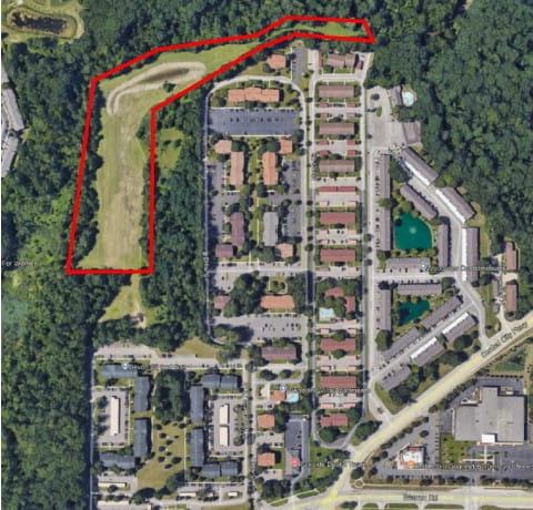
Nankin Township Landfill is a former dump site located in Westland, near the intersection of Cowan Road and Warren Road (behind Wilderness Park Apartments, 7280 Wilderness Park Drive). This property operated as the Nankin Township Landfill from approximately 1957 to approximately 1962. Based on aerial photographs, it appears to have been used as a landfill in the 1940s and 1950s as well. While operating as the Nankin Township Landfill, municipal and industrial waste were accepted, including industrial waste from 3M, a known PFAS manufacturer. The EPA performed a cleanup at the site in 1994-1995, removing 5,000 cubic yards of industrial waste and 350 waste drums. There is an exposure barrier currently in place to keep landfill materials from resurfacing and a creek erosion barrier that also acts as an exposure barrier. These barriers are inspected and maintained by Wayne County. A portion of this former dump site is a part of the Wayne County Parks system and includes a recreational hiking trail along Tonquish Creek, which is located on the northern and western boundaries of the site.
After a site file review, EGLE decided to investigate this site for PFAS based on the site historically accepting industrial waste from known PFAS manufacturer, 3M. In September 2024, EGLE installed seven groundwater monitoring wells and in October 2024, groundwater and surface water samples were collected from the site and analyzed. Results indicated that various PFAS compounds are present in the groundwater and surface water. The highest groundwater concentrations were 80 ppt PFOA (compared to 8 ppt) and 25 ppt PFOS (compared to 16 ppt). While there were PFAS detections in the surface water samples, there were no criteria exceedances. The general flow of groundwater is towards Tonquish Creek, which is located on the northern and western boundaries of the site. Tonquish Creek flows west to east and eventually connects with the middle branch of the Rouge River. Surface water samples from Tonquish Creek had PFAS detections but were below criteria.
Content posted January 2025.