The web Browser you are currently using is unsupported, and some features of this site may not work as intended. Please update to a modern browser such as Chrome, Firefox or Edge to experience all features Michigan.gov has to offer.
Kal-Haven Heritage Trail
Kal-Haven Heritage Trail
Pilot Project
Dedicated in 1989, the Kal-Haven Trail is the cornerstone of Michigan's outstanding network of linear trails. At that time, Michigan Department of Natural Resources planners described the trail as a "demonstration project" and a "pioneering effort, " because the conversion of rail corridors to trails was a relatively new concept. David Hales, former director of the DNR, told members of the volunteer organization that drove the project forward: "Your example will be critical to the start of a trail system in Michigan." Just as the development of the Kal-Haven Trail helped lay the groundwork for Michigan's trail system, it is now the pilot project for a program to integrate heritage on trails across the state.
The pilot project began in late 2015, with public meetings in Kalamazoo, Bloomingdale and South Haven. In 2016, volunteer work groups met regularly on design and research, an application was submitted to the Michigan Natural Resources Trust fund to finance the project, a thorough survey of the trail was completed, and the Michigan History Center's Heritage Trail Coordinator wrote an interpretive plan.
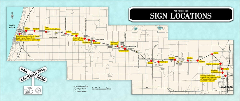
In summer 2019, the center and its partners installed 31 interpretive signs that share the natural and cultural history of the area. Travelers will see a glacially sculpted landscape that has been occupied by people for thousands of years, including the Pottawatomi. They called the South Haven area “Nik-o-nog," which means "beautiful sunset.” The trail passes through several communities that were founded in 1870, some of which have all but disappeared. Trail users can visit the place where Joe Louis ran the roads to get in shape for a fight with Jersey Joe Walcott, take in the site of an oil boom town and visit the site of one of the nation’s first woman-owned car dealerships.
In early 2020, an innovative mobile app designed for increased accessibility was added. It uses geo-location to alert users about nearby heritage sites and provides text and images to share the stories. It is also designed for increased accessibility. The app uses alt-tags, a tool that allows screen readers to provide a description of images to people with visual impairments. Android users can download the app on Google Play. Apple iPhone users can also access the app through a web browser at https://iwr.msu.edu/kht/.
Kal-Haven Heritage Trail Map
Download a PDF of the trail map.
