
Rochester Hills Multi-Site (Oakland County)

The Rochester Hills Multi-Site is made up of several historic, closed landfills that began operations around the 1950s. The landfills accepted a variety of waste types, including residential and industrial. The area is being redeveloped for various uses.

This web page serves as a central point for all of the PFAS sampling occurring in this redevelopment area.

Residential wells in the entire area were evaluated, and residents will be offered the opportunity to have their drinking water sampled for PFAS in the fall of 2026 if they have not already been sampled.

Details specific to each landfill

Allen Park Landfill

The Allen Park (aka Helen V Allen Park) Landfill, located at 1650-1790 School Road and Parcel 70-15-24-401-086, historically have been developed with dwellings and outbuildings starting in the 1930’s.

The southern and eastern portion of the site operated as a sand and gravel pit from the 1950’s-1960’s. By 1972 the pit was mostly overgrown, and in 1999 had significant ground disturbance. The area was then filled and turned into the current recreational field starting in 2006.

Groundwater onsite was sampled for PFAS in September 2025, and the highest concentrations were:

  • 56 ppt PFOA (compared to 8 ppt) and
  • 43 ppt PFOS (compared to 16 ppt)

Contact: Colleen McLean McLeanC1@Michigan.gov, 586-554-6489

Highland Park Woodfill

The Highland Park Woodfill, located at 1406 East Avon, was historically used for the disposal of trees by the City of Highland Park from the 1940’s to the 1990’s.

Buried fill material including tree stumps, tree limbs, and municipal waste was observed in test pits and soil borings completed on the property between 2004 and 2022.

Groundwater onsite was sampled for PFAS in October 2024, and the highest concentrations were:

  • 25 ppt PFOS (compared to 16 ppt) and
  • 14 ppt PFOA (compared to 8 ppt)

Contact: Colleen McLean McLeanC1@Michigan.gov, 586-554-6489

J & L Landfill

The J & L Landfill is approximately 17-acres in size and located near the intersection of Hamlin and Dequindre Roads in Rochester Hills, one mile west of the Clinton River.  The site was mined for sand and gravel until 1951 and from 1951 – 1980 it became the disposal location for wastes from steel manufacturing, which contaminated groundwater with benzene, metals and other chemicals.  The site is bordered by six other landfills and became an EPA Superfund site in 1989.

Steps taken to address contamination at the site include installing a cap on top of the landfill, fencing around the perimeter, and signage.  A sediment pond was also backfilled with clean fill, and culverts were sealed to prevent leachate from leaving the site.

In 2025, groundwater was sampled for PFAS and the highest concentrations were:

  • 510 ppt PFOA (compared to 8 ppt) and
  • 240 ppt PFOS (compared to 16 ppt).

Groundwater flows to the northeast toward Ladd Drain, a tributary of the Clinton River.

Contact: Nic Dawson DawsonN1@Michigan.gov, 517-897-0912

SOCRRA Avon Landfill

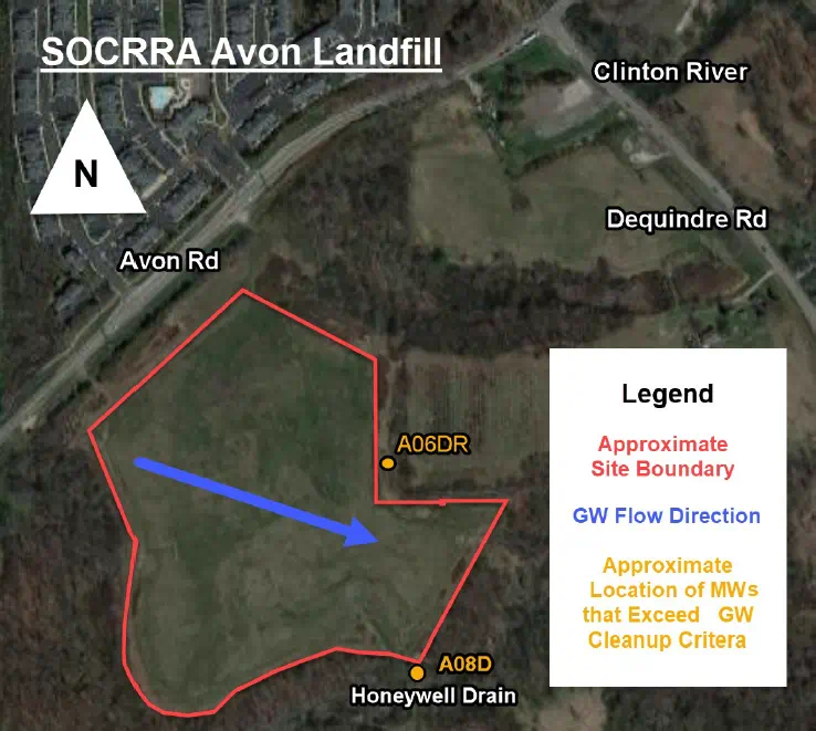
SOCRRA Avon Landfill is a 140-acre, closed sanitary landfill located at 1741 School Road. The site began receiving municipal solid waste in 1980 and was officially closed in 2005.

Based on the potential for PFAS-containing materials to have been disposed at the landfill and the fact that there are potential downgradient drinking water and/or surface water receptors, the Department of Environment, Great Lakes, and Energy (EGLE) requested groundwater sampling to be conducted to determine if PFAS contamination was present at levels that would require further action. Multiple rounds of sampling occurred between 2020 and 2025. The highest PFAS results were:

  • 89 ppt PFOA (compared to 8 ppt)

Groundwater flow is east-southeast to the Honeywell Drain, which is a tributary to the Clinton River.

Contact: Aaron Darling DarlingA5@Michigan.gov, 586-942-1910.

Map of SOCRRA Avon Landfill

Stan's Trucking Landfill

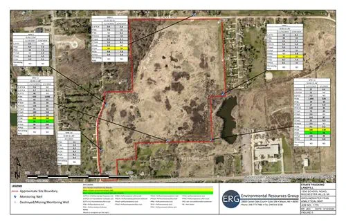
Stan’s Trucking, located at 1536 School Road, is a former Type II landfill used historically for general refuse, industrial wastes, and demolition wastes and was capped in 1984. Various remedial activities occurred over the next several decades, including the installation of a gas collection system to prevent methane gas leaks.

In November 2023 and February 2024, groundwater monitoring wells at the landfill were sampled for PFAS. The highest PFAS results were:

  • 260 ppt PFOA (compared to 8 ppt), and
  • 54 ppt PFOS (compared to 16 ppt).

Groundwater flow is to the east/northeast towards the Clinton River, approximately a half mile away.

Municipal water is available in the area, although many residents still use private wells. EGLE, DHHS and local health departments identified and sampled several nearby residential wells in the spring of 2024. Groundwater monitoring will continue and EGLE will evaluate data as it is received and expand sampling if necessary.

Contact: Kim Ethridge EthridgeK@Michigan.gov, 586-324-0183.

Stan's Trucking Landfill Map Preview