The web Browser you are currently using is unsupported, and some features of this site may not work as intended. Please update to a modern browser such as Chrome, Firefox or Edge to experience all features Michigan.gov has to offer.
Accomplishments To Date
Work has included a comprehensive evaluation of the terrestrial and Torch Lake water body portions of the Calumet and Hecla Lake Linden Operations Area (CHLL), Calumet and Hecla Tamarack City Operations Areas (CHTC), and Quincy Mining Company Mason Operations Area (QMCM) within the Project footprint (for a map of project areas, see “Project Background”).
Michigan Department of Environment Great Lakes and Energy (EGLE) Remediation and Redevelopment Division (RRD) Upper Peninsula District Office (UPDO) has shared Project findings with the public and other Project stakeholders, including the Michigan Department of Health and Human Services (MDHHS, formerly the Michigan Department of Community Health) for their review and input and to ensure that any public health concerns are identified and addressed.
Areas of asbestos containing building material (ACBM) and upland and sediment polychlorinated biphenyls (PCB) contamination have been identified, and hundreds of deteriorated drums have been located on the lake bottom. Information to allow public health risk evaluation at the two public beach areas and appropriate information has been shared with MDHHS and the beach area owners, and other private property owners.
The EGLE UPDO has undertaken numerous interim response actions to mitigate threats to human health and the environment. For conditions beyond EGLE's resources, referrals, have been made to the EPA Emergency Response Branch.
In 2014 and 2015
- PCB contamination at the former C&H Power Plant Building and the associated widespread asbestos contamination have been remediated under the oversight of the U.S. Environmental Protection Agency’s (EPA) Emergency Removal Branch;
- Asbestos contamination at the former Tamarack City Stamp Mill has also been addressed by the EPA’s Emergency Removal Branch;
- The presence of PCBs in the sediments at the Lake Linden Beach have been evaluated by MDHHS and have been determined to not pose an unacceptable risk to users of the recreation area due to either their depth within the sediment or the depth of the water;
- Hazardous substance (chemical contamination) risks have not been identified at the Hubbell Beach, although the owner has posted the beach advising users not to swim due to the presence of physical hazards (glass, rusted metal, etc.);
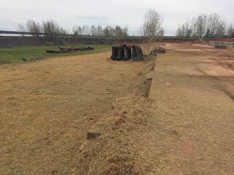
- An area accessible by residents in Tamarack City where asbestos was found (Tamarack City Trail Asbestos) has been covered and graded to prevent exposure (see below); and,

- The former Calumet Stamp Mill (currently occupied by the Houghton County Historical Society, and which is open to the public), where additional significant quantities of asbestos wastes have been found, has been referred to the EPA’s Emergency Removal Branch, who is currently working with the property owner and others to abate risks (see above).
In 2016
-
The former Coal Dock and Mineral Building properties in the Hubbell Processing Area, where significant deposits of upland PCB-containing wastes and contaminated soils have been identified, has been secured from public access;
-
ACBM located around the former Mineral Building in the Hubbell Processing Area has been removed (see below);

-
ACBM was removed and the remnants of an old dump area capped in the Ahmeek Mill Processing Area (see below, near the Tamarack City Park);

-
Geophysical investigations of suspected buried waste in the Tamarack City Sands and Hubbell Smelter areas have been conducted to determine the extent of wastes and containers buried beneath the Superfund cap. These buried wastes are slated for additional investigation in 2016 and removal in 2017;
-
In-lake side-scan sonar investigations were conducted in the Quincy Mining Company Mason (QMCM) portion of the Project footprint, in advance of on-land and in-lake investigation.
-
Conducted drainage ditch clean-out on the former Coal Dock property in the Hubbell Processing Area in order to allow for rain and snow-melt to flow along the original drainage ditch paths across the property and to avoid erosion of the PCB-containing wastes and contaminated soil into Torch Lake;
- Completed ACBM and RPM Removal IR operations at the Mineral Building and Coal Dock properties within the Hubbell Processing Area and at the Tamarack Processing Area including:
- Picked-up, contained, and transported for disposal all visible pieces of ACBM and suspect ACBM (SACBM) from the Hubbell Processing Area Coal Dock property totaling 0.14 tons of ACBM/SACBM.
- Picked-up, contained, and transported for disposal all visible pieces of ACBM and SACBM from the Hubbell Processing Area Mineral Building property totaling 1.77 tons of ACBM/SACBM.
- Picked-up, contained, and transported for disposal all visible pieces of RPM and suspect RPM (SRPM) from the Hubbell Processing Area Coal Dock and Mineral Building properties totaling 2, 55-gallon drums of PCB containing RPM/SRPM.
- Picked-up, contained, and transported for disposal all visible pieces of ACBM and SACBM from the Tamarack Processing Area totaling 1.19 tons of ACBM/SACBM.


- Completed Abandoned Container IR operations within the CHLL and CHTC including test pitting and characterization, transportation, and disposal of 118 abandoned containers:
- 1 from the Torch Lake Backwater Area.
- 67 from the Hubbell Processing Area Coal Dock property.
- 16 from the Hubbell Processing Area Mineral Building property.
- 2 from the Hubbell Slag Dump and Beach Area.
- 22 from the Tamarack Processing Area.
- 10 from the Tamarack Sands Area.
The contents of the drums were unknown, but based on field observations, drum contents appeared to include, but were not limited to, pine oil, silver paint-like material, lubricating oils, petroleum, granular materials, tailings and slag-like materials, and a watery white substance.


Removal Actions Completed in 2017
- Evaluation of results of several key studies conducted at the Lake Linden Recreation Area (LLRA) between 2005 and 2017 concluded that contamination exceeding health based and ecological criteria extends outward from the area along the shore that was the focus of a 2007 emergency removal. Based on these findings, in January 2017, EGLE requested assistance from the EPA ERB from Grosse Ile to address the contaminated sediments at the LLRA site. The EPA evaluated the existing information and is working with Honeywell Specialty Materials to further evaluate risks and develop a remedial approach for contaminated sediments. Representatives of EGLE, EPA, Michigan Department of Health and Human Services (MDHHS), Western Upper Peninsula Health Department (WUPHD), and Village of Lake Linden are collaborating to identify and implement measures to ensure the safety of the recreational area users.


- The EPA ERB continued working with Honeywell Specialty Materials and the Houghton County Historical Society to complete removal of asbestos near the foundations at the Museum in Lake Linden in spring 2017.

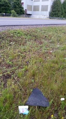
- Evaluation of results of several key studies conducted at the C&H Mineral Building between 2005 and 2017 identified potential threats to human and ecological receptors, including but not limited to: human health risks in the event of direct contact with polychlorinated biphenyls (PCBs) and metals contaminated surface soils, residual process materials (RPM), abandoned containers, waste piles, and stack debris; inhalation of particulates and asbestos containing building materials (ACBM); and physical hazards. Exposed ACBM, specifically roofing material that had fallen and/or been and continues to be blown off the roof of the Mineral Building, was present on the ground, waste pile, and stack debris surfaces, including outside of the fenced Site property in the Michigan Department of Transportation (MDOT) right of way (ROW) that includes a wide paved shoulder used heavily by local residents for recreational purposes (beyond which there are single-family residences). Based on the conditions the EGLE RRD completed a series of IRs and continued Site Investigation (SI) activities in 2016 and 2017 that included removal of 13.58 tons of ACBM, a 118-ton hazardous waste pile, and 16 abandoned containers. Based on these findings, in November 2017, EGLE requested assistance from the EPA ERB to address:
- Remaining waste piles, stack debris, and ACBM, including roofing materials that have been and will continue to fall and blow off of the Mineral Building roof onto the property, bordering properties, and the adjacent MDOT Highway M-26 ROW; and,
- Wind and water erosion and deposition of contaminated soils and wastes into the environment.
- The EPA evaluated the existing information, conducted a removal assessment, and is working with Honeywell Specialty Materials to further evaluate risks and develop a remedial approach. EGLE, EPA, MDHHS, WUPHD, Houghton County, and Torch Lake Township officials are collaborating to find a solution to the C&H Mineral Building property roof.


- A sampling and analysis plan (SAP) was developed for the Quincy Mining Company Mason Operations Area (QMCM) based on a comprehensive review of existing information and implemented during 2017 by the EGLE. Findings of the SI indicated the presence of ubiquitous ACBM, RPM and abandoned containers throughout the QMCM, including the Quincy Mill ruins west of M-26 that is frequented by recreational users. Note that these items were not addressed by the Torch Lake Superfund Site Cleanup project that did cap a portion of the QMCM east of M-26. Based on these findings, in November 2017, EGLE requested assistance from the EPA ERB to address the ACBM, abandoned containers, and RPM. EGLE and EPA have notified the property owners and representatives of the MDHHS, WUPHD, and Osceola Township of the study area conditions. The EPA is in the process of evaluating existing information and plans to conduct a removal assessment during 2018.


- Investigations at the former Hubbell Smelter property and on the south side of the Tamarack Sands indicated debris has been buried beneath the Superfund soil cap. Investigative activities also indicated PCB-contaminated soils eroding into Torch Lake at the former Hubbell Coal Dock property. To address the conditions in these three areas IRs were implemented during 2017.
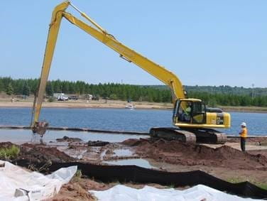
- Completed seep IR operations within the CHTC Tamarack Sands included test pitting, characterization, transportation, and disposal of 19.29 tons of seep material and restoration. The photos show the flowing, plasticizer-type waste being removed from one of the seep areas and the work area following restoration in accordance with EPA capping standards for the Torch Lake Superfund site.


- Completed IR operations on the Hubbell Smelter property shoreline included test pitting; characterization, transportation, and disposal of 10 abandoned containers and restoration in accordance with EPA capping standards for the Torch Lake Superfund site. The contents of the drums were unknown, but based on field observations, drum contents appeared to include, but were not limited to, hardened masses of granular materials in some cases embedded with copper wire and other metallic debris. One container included a whitish-sludge, similar to that observed in submerged drums in deeper water just offshore of the Hubbell Smelter property. All eight of the drums with contents contained PCBs. The photos show drums removed from beneath the cap at the water’s edge.


- In 2017 IR actions were undertaken at the Hubbell Coal Dock property, including:
- Capping of approximately 7-acres of PCB-contaminated soils to stop water and wind erosion and inhibit direct contact with;
- Replacement of approximately 170 feet of failing culverts;
- Improvement and armoring of 750 feet of drainage ditch;
- Removal and disposal of 320 pounds of ACBM and one drum of PCB-contaminated RPM; and,
- Removal and disposal of 118 tons of hazardous waste soil contaminated with PCBs and lead.


- The AMW project team started looking at the Quincy Mining Company operational areas from Dollar Bay down to the Portage Lift Bridge – the QMCP. We completed preliminary reconnaissance activities in 2017 including a side scan sonar survey. In 2018, we will complete a comprehensive review of existing information and develop a SAP to assist in the identification of historic areas of contamination or data gaps requiring further assessment. Subsequently, the SAP will be implemented and depending on the findings, IR actions may be undertaken to reduce the public’s potential for exposure to mining era wastes.
