The web Browser you are currently using is unsupported, and some features of this site may not work as intended. Please update to a modern browser such as Chrome, Firefox or Edge to experience all features Michigan.gov has to offer.
Driving water management with the power of data
July 26, 2023
Knowledge is power. The English philosopher and scientist Sir Francis Bacon said it more than 400 years ago, and researchers in the Great Lakes are proving it today. They’re gaining knowledge through data collection and using it to empower responsible management of our water resources. Here are two examples:
The Great Lakes Observing System (GLOS) supports a network of monitoring platforms to collect, analyze, and share lake and watershed data. GLOS’ Smart Great Lakes initiative (SGLi) leverages that network for data management and analysis, focusing on improved information systems, year-round observation, autonomous technology, and numerous partnerships.

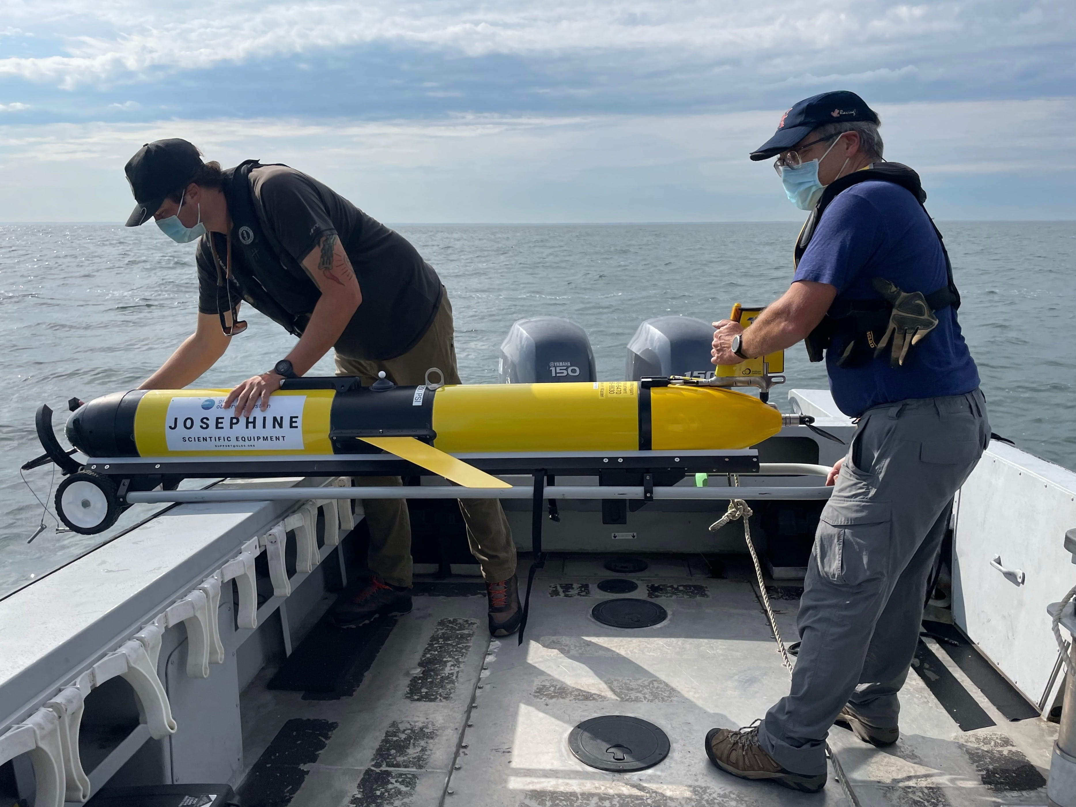
Researchers at the Cooperative Institute for Great Lakes Research (CIGLR) launch a GLOS autonomous underwater glider into Lake Erie to monitor conditions during a harmful algal bloom. Courtesy of CIGLR.
The Seagull IT platform, launched by GLOS as part of SGLi in early 2022, integrates different types of data collected in real time to create numerical model forecasts. Continuously improved to serve regional needs, Seagull provides free accessible data and information that is scalable and can connect to apps, dashboards, and other platforms.
GLOS also works to fill gaps in the regional observing network. Alongside the State of Michigan and the Mackinac Bridge Authority, GLOS supported Michigan Technological University’s (MTU) installation, testing, and operation of the first regional high-frequency radar. This system provides continuous surface current mapping of a portion of the Straits of Mackinac to improve navigation safety, aid in search-and-rescue missions, and monitor situations that could impact the ecosystem and public health.
GLOS also continues to support the development of early warning systems that help people understand environmental hazards. Currently, GLOS is working with the National Oceanic and Atmospheric Administration’s (NOAA) Great Lakes Environmental Research Laboratory (GLERL), Florida Atlantic University, the University of Wisconsin-Milwaukee, and Cellcom to test and deploy technologies that can help characterize the presence and toxicity of harmful algae blooms (HAB). This work is part of the Great Lakes National Harmful Algae Bloom Observing Network (NHABON) Pilot Project, begun in 2020 with support from NOAA’s Integrated Ocean Observing System (IOOS).
Great Lakes winter data is scarce, which hinders the understanding and forecasting of lake processes. GLOS is working with regional partners to expand the current Great Lakes observing network to include monitoring platforms capable of year-round real time data collection starting with some deployments by the end of 2023.
Work also is underway to expand the Great Lakes fleet of autonomous vehicles that can collect data continuously over large areas and long time periods to monitor ecosystem dynamics, track fish movement, monitor HABs, and assess climate variability. These platforms are being operated by regional partners like NOAA-GLERL, University of Windsor-RAEON, CIGLR, University of Wisconsin-Milwaukee, MTU, and University of Minnesota-Duluth.
GLOS supports Ontario-based Trent University’s work to explore the need for a network of Great Lakes-based Indigenous communities and organizations focused on fisheries science and management, as well as data governance and sovereignty challenges.
GLOS is also crowdsourcing bathymetry data to help map the Great Lakes in collaboration with Orange Force Marine and a volunteer network of vessel owners, and using funds set aside to IOOS from the Bipartisan Infrastructure Law of 2022 to upgrade and replace aging monitoring platforms and instrumentation throughout the Great Lakes region. This ensures continuation of data streams used to assess safety and protect economic and ecological benefits from the lakes.
EGLE’s Water Use Program (WUP) registers large-quantity water withdrawals (LQW), collects annual water use data, makes determinations on the potential impacts to water resources from proposed withdrawals, and processes water withdrawal permits. Information managed by the program provides an environmental baseline for managing water resources in an integrated manner and strengthens the legal basis for opposing unwarranted diversions of Great Lakes water.
If you want to assess the impact of withdrawing large amounts of water from a watershed, you need to know how the water flows. WUP measured streamflow in summer 2023 at 23 sites in Michigan watersheds.
A joint funding agreement with the U.S. Geological Survey (USGS) provides for streamflow measurements at 30 additional sites and continuous gages that measure daily streamflow year-round at 15 sites, and there are plans to install at least eight additional USGS continuous gages – possibly more with additional funding.
This data will improve 3-D models of groundwater, surface water, and streamflow depletion that can help determine the effects of new and existing LQW.
Using a wide variety of data, the program helps manage Michigan’s surface water and groundwater resources to protect streamflow and fish populations. Measurements collected by staff and from the continuous gages show watershed status in real time and provide insight on the impact of LQWs and climate.
The program plans to collect more hydrologic data to analyze streambed conductivity: the ability of water to move in either direction between the stream and the underlying groundwater. The program will continue monitoring previously visited watersheds while exploring additional watersheds.
The Michigan Legislature appropriated $10 million for the program in fiscal years 2022 and 2023 to support Water Use Advisory Council (WUAC) recommendations. Some of this funding will be used to keep the 15 stream gages operating through September 2024 and install the additional gages.
Adapted from articles in the 2022 Michigan State of the Great Lakes Report by Ana Sirviente of the Great Lakes Observing System and Clayton Joupperi of the Michigan Department of Environment, Great Lakes, and Energy.