
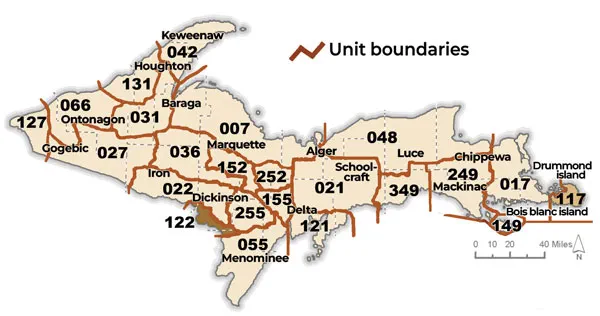
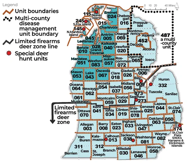
Please note that this DMU information is updated every three years, and as a result, the map below will match the DMU map from the year they were last updated and may not match the current DMU map in the Deer Hunting Regulations Summary.
Select a DMU to view background management info for that area: 003, 005, 006, 007, 008, 009, 010, 013, 015, 016, 017, 018, 019, 020, 021, 022, 023, 024, 025, 026, 027, 028, 029, 030, 031, 033, 034, 036, 037, 038, 040, 041, 042, 043, 044, 045, 046, 047, 048, 050, 051, 053, 054, 055, 056, 057, 058, 059, 061, 062, 063, 064, 065, 066, 067, 069, 070, 072, 073, 074, 078, 081, 082, 083, 115, 117, 121, 122, 127, 131, 149, 152, 155, 174, 245, 249, 252, 255, 273, 311, 312, 332, 349, 452, 487
DMU 003 – Allegan County
Area Description
The Allegan County Deer Management Unit has a long history of supporting abundant deer populations. The core of the County is the 50,700 acre Allegan State Game Area (SGA), which covers about 9 % of the County. The Allegan SGA provides good habitat with a mix of Riparian areas and upland Oak Barrens. To the north, East and South, agriculture dominates much of the private land with small woodlots intermixed. The Lakeshore is characterized by specialty crops like Blueberries, sand dunes, and large residential housing developments, all providing good habitat for deer.
Management Guidance
Two main goals guide the deer management in this DMU: 1) impact management; and 2) hunting opportunities. Impact management refers to reduction of undesirable effects associated with deer over-abundance, such as crop damage, deer-vehicle collisions, and poor forest regeneration due to over-browsing are examples. It is important that deer hunters have access to lands where deer are abundant. Public hunting land in Allegan County is about 9% of the county land mass. Deer are abundant on Public Land, as a result, hunting pressure is present throughout all deer seasons. Private landowners manage most of the land in this County and should work together with hunters to provide access to manage deer populations. Areas where hunting opportunity is limited, such as Urban areas, are experiencing increasing abundance of deer, and associated undesirable effects. Recent trends from harvest data indicate that populations of deer in most areas of the County are increasing.
Deer Management Recommendations
Deer in this DMU have likely been increasing the last five years. Total harvest and buck harvest seem to be unaffected by EHD, which occurred in areas primarily associated with the Kalamazoo River in 2024. Notably, Antlerless harvest increased in 2024, and this increased level of harvest continued in 2025, with antlerless deer harvest surpassing buck harvest. Late Antlerless season expanded to Public Land in 2024 as well as the new Extended Antlerless season in January. Total Deer Harvest is slowly increasing from 2022 to 2025. To continue managing an increasing deer population across the County, and balance harvest efforts between Public and Private lands, the following requested changes are recommended:
- Recommend Late Antlerless and Extended late Antlerless return to PRIVATE Land ONLY
- Rationale: Most deer are on Private Land and these seasons should have hunters concentrating efforts there, rather than public land where deer are heavily hunted and heavily harvested.
DMU 005 – Antrim County
Previous 5-year trend: Stable | Desired trend: Stable
Area Description
Antrim County Deer Management Unit (DMU 005) is in the Northern Lower Peninsula Region (NLP). The DMU consists of 503 square miles of land. Approximately 88% of the DMU is in privately held lands. The remainder (12%) is in public ownership.
The landscape is primarily private agricultural land mixed with forest in the central and western portions of the DMU. Agricultural lands include orchards and vineyards near the Lake Michigan shoreline. Other agriculture is dominated by variety of crops and pastureland where soils and landscape allow. Much of the non-agricultural private land is forested with a mixture of upland forests and swamp. The Jordan River is a major riparian area that runs through the DMU and a large portion of public land is concentrated around the river it’s tributaries. Deer densities on private lands around the agricultural/forest interface tend to be higher than in the publicly held lands.
Management Guidance
Two main goals guide the deer management in this DMU: 1) impact management; and 2) hunting opportunities. Impact management refers to reduction of undesirable effects associated with deer over-abundance and include crop damage, deer-vehicle collisions, and poor forest regeneration due to over-browsing. In order to balance hunting and wildlife viewing opportunities with unwanted impacts such as crop damage, we review trends in data from several sources to adjust the harvest strategy as needed. Trends considered include deer harvest information from mandatory deer harvest reporting, annual deer hunter survey results, deer-vehicle collision data from the Michigan State Police, and deer-related information collected by regional wildlife biologists (e.g., number of deer damage shooting, nuisance deer, and deer management assistance permits).
This DMU has antler point restrictions (APRs), that limit which antlered deer (bucks) can be harvested by hunters to provide a mechanism for yearling bucks to graduate into older age classes. The APRs in place are part of a strategy called Quality Deer Management (QDM), which involves 1) APRs, 2) maintaining deer numbers below the biological carrying capacity, and 3) striving for an equal buck to doe ratio in the deer population. Antlerless deer (doe and fawn) harvest is recommended under QDM as a means of reaching achieving the second and third principles of QDM.
Deer Management Recommendations
Deer population indices in this DMU indicate that deer numbers appear to be stabilizing. Minor interannual variation in harvest over the last 5 years is most likely attributed to winter weather conditions. Trends in antlered and antlerless harvest in the DMU continue to be near a 1:1 ratio. A significant ice storm hit the region in late March of 2025, however impacts in the county appeared to be minimal and were mostly observed in eastern portions of the DMU. Rotational CWD surveillance detected no CWD cases. Deer vehicle collisions have continued to increase over the last five years, reflecting continued long-term trends. Deer management assistance permits (DMAPs) and deer damage shooting permits (DDSPs) have declined in recent years though use has remained relatively stable through time to address agricultural conflicts. Much of this decrease can be attributed to the introduction of universal antlerless licenses which reduced the need for DMAPs to address localized areas of higher deer densities.
Regulation changes 1) muzzleloading season opened to any legal firearm, and 2) early and late antlerless firearms seasons open on public land, have been in place since 2024. These changes aim to address goals for reducing conflict and increased hunting opportunity throughout the northern peninsula and other regions in the state. It is too early to assess the impact of these regulations on harvest, and we recommend no change to the current regulation structure to monitor trends over this regulations cycle to evaluate impacts to harvest, population dynamics and human-deer conflict.
The goal for this DMU is to achieve a stable population, with the recognition that localized differences in deer densities will persist due to habitat variability and landscape characteristics. Hunting remains the primary management tool to achieve identified goals, while also providing important social, cultural, and economic benefits to the local community. DDSPs and DMAPs,, used to address areas of higher deer densities on private lands, will continue to be issued in areas where there is demand and available hunting opportunities are unable to address conflict.
DMU 006 – Arenac County
Previous 5-year trend: Increasing | Desired trend: Stable
Area Description
The Arenac County Deer Management Unit (DMU) 006 is in the Northern Michigan Region (NMR). It has roughly 248,320 acres and consists of nearly 51% forested; 27% crop land, 3% pasture and idle grasslands. About 19 % of the land use is urban. Only 14 % of Arenac County is in public ownership, the majority of which is located on the western and central portions of the county. Substantial human population growth has occurred along the Lake Huron shoreline and in the community of Standish during the past 20 years. Deer numbers are generally low in these urban areas although deer complaints received have been increasing over the last five years.
Management Guidance
Three main factors guide the deer management in this DMU: 1) landscape impact management; 2) hunting opportunities; and 3) maintaining a healthy deer herd. Impact management refers to reduction of undesirable effects associated with deer over-abundance and in this DMU it includes crop damage, deer-vehicle collisions, and poor forest regeneration due to over-browsing. Efforts have been made to find a middle ground in which deer numbers provide ample hunting and wildlife viewing opportunities and mitigate unwanted impacts. We review data from several sources to adjust the harvest strategy as needed. That data includes deer harvest data from check stations and an annual mail survey, deer-vehicle collision data from the Michigan State Police, deer-related information collected by regional wildlife biologists (e.g., number of Crop Damage Permits, Disease Control Permits, residential property damage, Deer Management Assistance Permits, forest regeneration assessments, etc.). Herd health is monitored through the collection of specimens obtained from deer hunters, deer permit holders, and targeted surveillance. Engagement with the public through surveys, electronic communication and face-to-face interaction is an important part of deer management and the regulations establishment process.
Deer Management Recommendations
Arenac County has a deer population that has been increasing the past ten years. There has been a significant increase in the number of crop damage complaints in conjunction with, increasing numbers of Out of Season Kill Tags requested by individual farmers. Deer-vehicle collisions have remained stable over the last four years. Harvest of antlerless deer over this same period has been stable.
Hunting opportunities in DMU 006 are plentiful. The 34,765 acres of public land provide suitable habitat for deer hunting and includes ample hunter access. A casual deer hunter camp survey, on public land, has been conducted by DNR staff and indicates that hunting pressure on these public lands is slightly decreasing. On the 213,555 acres of private land the opportunities for hunting deer are also abundant, in fact there are many tracts of private land that are used explicitly for deer hunting.
We recommend following current deer harvest regulations that allow each hunter to purchase 10 universal antlerless tags in addition to either a single deer tag or combination tags. The challenge to increase harvest of antlerless deer is underutilized harvest opportunity by hunters on both private and public land throughout the entire deer season.
DMU 007 – Marquette, Baraga, and Alger County
Area Description
Deer Management Unit (DMU) 007 is 1,788 miles2 in size and is comprised of the northern portions of Baraga and Marquette Counties, and the northwestern portion of Alger County. This unit has the most Lake Superior shoreline of any DMU which heavily influences the weather/winter severity and snow depths. Approximately 84% of this DMU is privately owned land, with roughly 23% enrolled in the Commercial Forest Act, and about 16% held in public ownership (State or Federal).
Land use and habitat quality for deer in DMU 007 range from lowland conifer and wetlands to upland hardwoods, dry grassland openings and jack pine barrens, which provide relatively low to fair quality habitat for deer in much of this unit. Several deer wintering complexes lie within this unit, including Menge Creek (near L’Anse), Huron Mountains, Harlow Lake-Big Bay, and Sand River. Agricultural influence is very limited and primarily only a factor near traditional rural communities.
The city of Marquette and surrounding towns lie within DMU 007, and residents are often vocal about deer management. Hunter opinions can be divided by method of take: firearm hunters desire more deer and generally are not interested in antlerless harvest in this unit, and archery hunters desire opportunity for antlerless take (although archers seem to acknowledge northern 007 deer numbers [i.e., north of US 41] may not warrant the harvest of does, but the southern portion might support antlerless take). Agricultural interests centered around Marquette have expressed interest in lowering deer numbers—however, nearby winter deer feeding operations are contrary to this effort and such stakeholders are vocally opposed to lowering deer populations.
Management Guidance
The main goal guiding deer management in DMU 007 is to provide hunting opportunities. However, both deer densities and hunting success rates are below average in DMU 007 for the Western Upper Peninsula (WUP). Because of the relatively low deer numbers, antlerless permits have not been available for DMU 007 for many years if ever. There is very little agricultural activity due to the harsh winter conditions and generally sandy soil types found in this DMU. Outside of the deer wintering complexes and feeding sites deer browsing has not impacted tree regeneration.
This unit is in a high snowfall zone and deer in this unit experience harsh winter conditions compared to other portions of the Upper Peninsula (UP). Annual snowfall is generally 250 to 275 inches of snowfall in the northern portions of this DMU due to the influence of Lake Superior. Consequently, deer in this unit exhibit relatively poor reproductive potential compared to other DMU’s in the UP.
Deer Management Recommendations
Buck harvested/mile2 is relatively low in DMU 007 deer compared to the rest of the WUP and opportunities to harvest antlerless deer have been generally restricted for the last years.
Buck harvested/mile2 has been variable over the years but overall, it has shown a general decline in 24 years. This variability can be explained by the frequency of severe winters for deer (winters with 90 days or more with at least 12-inch snow). Since 2013, eight of the 13 (62%) have been severe. These long winters with high energy expenditure for navigating the landscape during periods of deep snow and poor nutritional value of available food in this DMU during the winter will make it very difficult for the population to make an upward trend. DMU 007 still consistently ranks as one of the lowest units for buck harvest. This harvest rate signifies a relatively low deer herd compared to the rest of the WUP. Currently reported local herd indicators, (camp survey, car deer accidents, deer management assistance permit, crop damage, and population projections) indicate that deer herd densities remain relatively low.
Because of these indicators and the relatively low deer densities found in this DMU, it is recommended that DMU 007 should remain closed to general antlerless permits (private, public, or late season). While I would prefer to close antlerless take with archery equipment biologically the low level of antlerless harvest in 2025 (160 does or .09 does per mile2) does not warrant a regulation change during the 2026 regulation cycle. Local deer density issues associated with agricultural operations are minimal in this unit and can be effectively dealt with by utilizing crop damage or deer management assistance permits.
DMU 008 – Barry County
Previous 5-year trend: Stable | Desired trend: Decrease
Area Description
The Barry County Deer Management Unit (DMU 008) in the Southern Lower Peninsula Region is mostly private property with 10% of the area being public land. Most public hunting opportunities in the Barry County DMU are available on the Barry State Game Area (16,828 acres), Middleville State Game Area (4,585 acres) and Yankee Springs State Recreation Area (5,200 acres). The public lands in this DMU are predominantly forested habitat providing cover for deer (e.g., woodlots, shrub/brush, and wetland). Greater than 90% of this DMU is private land composed of a fragmented landscape of agriculture intermixed with forests and wetlands. Topography for Barry County varies from rolling hills to relatively flat ground with soils that are generally well-suited to row crop agriculture.
Management Guidance
Two goals guide deer management decisions for this DMU: 1) impact management; and 2) hunting opportunities. Impact management refers to the reduction of undesirable effects associated with high deer densities. Examples of undesirable deer impacts include crop damage, deer-vehicle collisions, and poor forest regeneration due to over-browsing. We aim to provide ample hunting and wildlife viewing opportunities while reducing negative impacts from deer. To accomplish this, we review data from several sources to assess management goals in this DMU. The data includes deer harvest reports, deer check station data, annual mail survey information, deer-vehicle collision data, and deer-related information collected by regional wildlife biologists (e.g., number of crop damage permits, reports from local hunters, habitat assessments, etc.).
Deer Management Recommendations
From 2022 to 2025, an average of 4,400 deer were harvested per year in the Barry County DMU (3,589 in 2025). During this period, 54% of harvests were antlered and 46% were antlerless. The number of deer harvested declined each year during this period with a total decline of 29%. Deer-vehicle collisions were down 5% from the 5-year average. Despite these declines, crop damage complaints in 2024 were up 65% from the 5-year average. The reduction in harvest may suggest a decline in deer numbers for the Barry County DMU. Currently, the deer population is still above the desired level across the DMU. Harvest should focus on reducing antlerless deer, and landowners should continue to utilize the hunting seasons to control deer on private land.
As of February 2026, chronic wasting disease has not been detected in Barry County. Cases have been confirmed in adjoining counties to the north, west, and east.
DMU 009 – Bay County
Previous 5-year trend: Increase | Desired trend: Decrease
Area Description
The Bay County Deer Management Unit (DMU 009) is located in the Southern Lower Peninsula in the Saginaw Bay region of Wildlife Division’s Southeast Region management unit. Bay County, at 428 square miles, contains roughly 10,850 acres of public land comprised of properties owned and managed by the Department of Natural Resources Wildlife Division and Parks Division. Public lands open to deer hunting in DMU 009 are:
- Nayanquing Point State Wildlife Area*
- Fraser Township #1 State Game Area
- Fraser Township #2 State Game Area
- Pinconning Township (Cody-Esty Road) State Game Area
- Crow Island Sate Game Area, northern portions that lie in Bay County
- Quanicassee State Wildlife Area, western portions that lie in Bay County
- Tobico Marsh Wildlife Unit of Bay City State Recreation Area
*Due to Nayanquing Point State Wildlife Area also being an intensively managed waterfowl hunt area, deer hunts are regulated through drawings and occur in accordance with annual waterfowl seasons and area conditions; hunters interested in pursuing deer at this location will need to call the local field office (989-697-5101) in advance for specific information.
Topography in DMU 009 is generally flat with lake plain soils that are well-suited to row crop agriculture. Outside of northwestern portions of the county, which contain some large contiguous blocks of private forest land, habitat in this DMU is highly fragmented due to the predominance of agriculture. This DMU also contains urban areas of Bay City, and suburban and exurban areas of both Bay City and Saginaw. With the exception of State Game and Wildlife Areas, along with the previously mentioned private land forest stands, habitat providing cover for deer (e.g., woodlots, shrub/brush, and wetlands) is relatively isolated and exists in small patches. A county-level and public land breakdown of habitat composition, by percentage, for DMU 009 can be found in Table 1.
Table 1. Habitat composition of DMU 009 as compared to only public land located within DMU 009
| Habitat | DMU 009 | Public Lands in DMU 009 |
|---|---|---|
| Forest | 17.6 | 18.1 |
| Agriculture | 59.5 | 28.4 |
| Grass/Shrubland | 7.3 | 6.8 |
| Wetland | 3.9 | 26.3 |
| Developed | 10.0 | 2.0 |
| Water | 1.3 | 16.8 |
| Bare/Rocky | 0.5 | 1.6 |
Management Guidance
Two main goals guide deer management in this DMU:
- Impact management
- Hunting opportunities
Impact management refers to reduction of undesirable effects associated with deer over-abundance, with examples being crop damage, deer-vehicle collisions, and poor forest regeneration due to over-browsing. In an effort to find a middle ground in which deer numbers provide ample hunting and wildlife viewing opportunities, while trying to mitigate unwanted impacts, DNR reviews data from several sources to adjust harvest strategies as needed. These data include deer harvest data from mandatory deer harvest reports (initiated Fall 2022), winter severity indices, deer-vehicle collision data from the Michigan State Police, and deer-related information collected by regional wildlife biologists (e.g., number of crop damage permits issues, habitat assessments, etc.).
Deer Management Recommendations
The deer population in this DMU has continued to increase, likely due to mild winters and ample food resources throughout the year and increasing row crop efficiency. As such, issuance of deer management assistance permits (DMAP) and deer damage permits (DDP) continue to be required to alleviate crop damage complaints. The number of DMAP and DDP tags issued continues to increase, doubling in issuance and utilization within the last 10 years highlighting the need to continue to suppress increasing deer populations on private lands outside of standard hunting seasons.
While high deer densities continue to provide ample hunting opportunities, recommendations to increase antlerless harvest will remain, encouraging the 10 universal antlerless license utilization, particularly on private lands. Antlerless harvest marginally overcame antlered harvest in Bay County per mandatory deer harvest reporting data in 2024, though significant separation in antlerless to antlered harvest totals are still desired.
DMU 010 – Benzie County
Previous 5-year trend: Increasing | Desired trend: Stabilize
Area Description
The Benzie County Deer Management Unit (DMU 010) has roughly 62,000 acres of State Forest Land which is about 31% of the total acreage in the county. Topography is relatively flat (lake-border plains and sandy outwash plains) with small inclusions of hills. State Forest is concentrated in a north/south strip near the middle of the county.
Soils in the unit vary from well drained sand mixes to poorly drained peat and muck soils. The drier soils support mixes of pine, oak, aspen, and red maple on the outwash plains to the south and northern hardwoods on the moraine hills in the north. Poorly drained soils support various wetland communities. Row crop agriculture and orchards can be found predominately along the lakeshore.
The Grass Lake (or Bendon Swamp) in the southeast and the Deadstream Swamp in the northwest are the area’s most significant winter yarding complexes. Other traditional winter yarding areas occur along various riparian corridors including the Platte and Little Betsie Rivers and creeks such as Dair Creek. Riparian corridors also provide important travel routes for deer and other species. Herring Swamp is another sizeable yarding area but is situated entirely on private lands. Numerous pine stands provide thermal cover in upland areas as well.
Management Guidance
Two main goals guide deer management in this DMU: 1) impact management; and 2) hunting opportunities. Impact management refers to reduction of undesirable effects associated with deer over-abundance and in this DMU includes crop damage, deer-vehicle collisions, and poor forest regeneration due to over-browsing. Hunting opportunities refers to providing a large enough deer population to meet hunters’ criteria for what they consider a quality hunting experience. A third factor that needs to be considered is that DMU 010 is within the NW Antler Point Restriction (APR) Zone. APRs limit which antlered deer (bucks) can be harvested by hunters to provide a mechanism for yearling bucks to graduate into older age classes. The APRs in place are part of a strategy called Quality Deer Management (QDM), which involves 1) APRs, 2) maintaining deer numbers below the biological carrying capacity, and 3) striving for an equal buck to doe ratio in the deer population. Antlerless deer (doe and fawn) harvest is recommended under QDM as a means of reaching achieving the second and third principles of QDM.
Deer Management Recommendations
Recent population trends suggest a stable to slightly increasing deer population. Possibly due to repeated mild winters and a gradual but steady decline in hunters. The advent of the Universal Antlerless License may have boosted an increase in antlerless harvest. Deer harvested on Deer Damage Shooting Permits (DDSPs) have increased only slightly over the past 10 years but still only make up a small fraction of the annual deer harvest. Deer populations can put a strain on resources available to deer. This can be evidenced by increased or steady agricultural damage complaints and observations of deer browse to forest regeneration. Past efforts to increase doe harvest (i.e. an increased antlerless quota) have brought the doe harvest numbers closer to that of the buck harvest, so it appears to be having the desired effect.
Based on current trend analyses, we are recommending to maintain the current antlerless harvest strategy within this DMU. The current deer population status appears to be balanced between preventing an increased need for DDSPs and still supporting recreational deer hunting on public and private ownerships. Creating additional hunting opportunities to harvest does specifically on private lands should help to mitigate crop damage and eventually, slightly reduce the population, which is consistent with the APR management philosophy. Reducing the population will help with reducing deer-vehicle collisions.
DMU 013 – Calhoun County
Previous 5-year trend: Increase | Desired trend: Decrease
Area Description
The Calhoun County Deer Management Unit (DMU 013) is in the Southern Lower Peninsula Region. Currently there are no public land hunting opportunities in Calhoun County. This DMU has an open agricultural landscape intermixed with forests and wetlands. DMU 013 is home to the city of Battle Creek, a large metropolitan area in the Northwest portion of Calhoun County, and accounts for about 43 square miles of the landscape. Topography for Calhoun County varies from rolling hills to relatively flat with soils that are generally well-suited to row crop agriculture.
Management Guidance
Two goals guide deer management decisions for this DMU: 1) impact management; and 2) hunting opportunities. Impact management refers to the reduction of undesirable effects associated with high deer densities. Examples of undesirable deer impacts include crop damage, deer-vehicle collisions, and poor forest regeneration due to over-browsing. We aim to provide ample hunting and wildlife viewing opportunities while reducing negative impacts from deer. To accomplish this, we review data from several sources to assess management goals in this DMU. The data includes deer harvest reports, deer check station data, annual mail survey information, deer-vehicle collision data, and deer-related information collected by regional wildlife biologists (e.g., number of crop damage permits, reports from local hunters, habitat assessments, etc.).
Deer Management Recommendations
From 2022 to 2025, an average of 5,700 deer were harvested per year in the Calhoun County DMU (5,573 in 2025). During this period, 54% of harvests were antlered and 46% were antlerless. The number of deer harvested remained stable throughout this period. Deer-vehicle collisions were up 15% from the 5-year average but have been relatively stable over the last decade. Crop damage complaints in 2024 were up 72% from the 5-year average. The stable deer harvest numbers, increasing deer-vehicle collisions, and increasing crop damage complaints may suggest deer numbers are still increasing in this DMU. Currently, the deer population is still above the desired level across the DMU. Harvest should focus on reducing antlerless deer, and landowners should continue to utilize the hunting seasons to control deer on private land.
As of February 2026, chronic wasting disease has not been detected in Calhoun County. Cases have been confirmed in adjoining counties to the north, east, and south.
DMU 015 – Charlevoix County
Previous 5-year trend: Stable | Desired trend: Stable
Area Description
Charlevoix County Deer Management Unit (DMU 015) is in the northern lower peninsula. The DMU consists of 440 square miles of land, approximately 18% of the DMU is contained in public ownership, the remainder 82% is privately held. Large lakes, including Lake Charlevoix, make up a large portion of this county. Human populations and developments (Charlevoix, Boyne City, East Jordan) tend to be near these large waterbodies and Lake Michigan.
The landscape is primarily private agricultural land mixed with forest and developed areas in the central and western portions of the DMU. Agricultural lands include orchards and vineyards near the Lake Michigan shoreline. Other agriculture is a variety of crops and pastureland where soils and landscape allow. Much of the non-agricultural private land is forested with a mixture of upland forest and swamp complexes. Forested public lands are scattered throughout the DMU, but lie primarily in the eastern portions. Deer densities on private lands around the agricultural/forest interface tend to be higher than in the publicly-held lands.
Management Guidance
Two main goals guide the deer management in this DMU: 1) impact management; and 2) hunting opportunities. Impact management refers to reduction of undesirable effects associated with deer over-abundance and include crop damage, deer-vehicle collisions, and poor forest regeneration due to over-browsing. In order to balance hunting and wildlife viewing opportunities with unwanted impacts such as crop damage, we review trends in data from several sources to adjust the harvest strategy as needed. Trends considered include deer harvest information from mandatory deer harvest reporting, annual deer hunter survey results, deer-vehicle collision data from the Michigan State Police, and deer-related information collected by regional wildlife biologists (e.g., number of deer damage shooting, nuisance deer, and deer management assistance permits).
This DMU has antler point restrictions (APRs), that limit which antlered deer (bucks) can be harvested by hunters to provide a mechanism for yearling bucks to graduate into older age classes. The APRs in place are part of a strategy called Quality Deer Management (QDM), which involves 1) APRs, 2) maintaining deer numbers below the biological carrying capacity, and 3) striving for an equal buck to doe ratio in the deer population. Antlerless deer (doe and fawn) harvest is recommended under QDM as a means of reaching achieving the second and third principles of QDM.
Deer Management Recommendations
Deer population indices in this DMU indicate that deer numbers appear to be stabilizing. Minor interannual variation in harvest over the last 5 years is most likely attributed to winter weather conditions. A significant ice storm hit the region in late March of 2025; western portions of the DMU fared well, while the most significant impacts were observed further east around the Chandler Hills area. This significant weather event will likely influence deer populations and habitat conditions in the coming years. Rotational CWD surveillance detected no CWD cases. Vehicle-deer incidents have historically been high, but have declined from a record high in 2018 (729). Deer management assistance permits (DMAP) have declined significantly in the DMU with much of this decrease attributed to the introduction of universal antlerless licenses which reduced the need for DMAPs to address localized areas of higher deer densities. Deer damage shooting permits (DDSP) have increased slightly to address agricultural conflicts with only a nominal increase in utilization.
Regulation changes 1) muzzleloading season opened to any legal firearm, and 2) early and late antlerless firearms seasons open on public land, have been in place since 2024. These changes aim to address goals for reducing conflict and increased hunting opportunity throughout the northern peninsula and other regions in the state. It is too early to assess the impact of these regulations on harvest, and we recommend no change to the current regulation structure to monitor trends over this regulations cycle to evaluate impacts to harvest, population dynamics and human-deer conflict.
The goal for this DMU is to achieve a stable population, with the recognition that localized differences in deer densities will persist due to habitat variability and landscape characteristics. Hunting remains the primary management tool to achieve identified goals, while also providing important social, cultural, and economic benefits to the local community. DDSPs and DMAPs, used to address areas of higher deer densities on private lands, will continue to be issued in areas where there is demand and available hunting opportunities are unable to address conflict.
DMU 016 – Cheboygan County
Previous 5-year trend: Stable | Desired trend: Stable
Area Description
The Cheboygan County Deer Management Unit (DMU 016) is in the northern lower peninsula. The DMU consists of 758 square miles of land, approximately 65% of the DMU is in privately held lands. The remainder (35%) is in public ownership. This DMU contains several large lakes including Burt, Mullett, and Black Lakes, as well as associated wetland and swamp complexes.
The landscape is primarily forested public and private recreational lands with inclusions of human developments including the towns of Wolverine, Indian River, Cheboygan, Mackinac City, and outlying areas. Agricultural lands including primarily row crops and pastureland are found in the northern and eastern portions of the county interspersed with forestlands. Much of the non-agricultural private land is forested with a mixture of upland forest and forested wetlands. Larger tracts of public lands can be found in this DMU and are managed by the Pigeon River and Gaylord Forest Management Units. Deer densities vary across the DMU and may be impacted negatively by harsh or long winter conditions. Higher concentrations of deer are located in the agricultural/forest interface and swamp/open lands, especially in the eastern and northern areas of the DMU.
Management Guidance
Three main factors guide the deer management in this DMU: 1) landscape impact management; 2) hunting opportunities; and 3) maintaining a healthy deer herd. Impact management refers to reduction of undesirable effects associated with deer over-abundance. Crop damage, deer-vehicle collisions, and poor forest regeneration due to over-browsing are examples. In an effort to find a middle ground in which deer numbers provide ample hunting and wildlife viewing opportunities and mitigate unwanted impacts, we review data from several sources to adjust the harvest strategy as needed. Those data include deer harvest data from mandatory harvest reporting and an annual mail survey, deer-vehicle collision data from the Michigan State Police, and deer-related information collected by regional wildlife biologists (e.g., number of deer damage shooting permits, disease control permits, residential property damage, deer management assistance permits, forest regeneration assessments, surveys run by cooperators, etc.). Herd health and disease prevalence are monitored through the collection of specimens obtained from deer hunters, deer permit holders, and targeted surveillance.
Deer Management Recommendations
Deer population indices in this DMU indicate that deer numbers appear to be stabilizing. Minor interannual variation in harvest over the last 5 years is most likely attributed to winter weather conditions. A significant ice storm hit the region in late March of 2025, this DMU was hit hard and had significant damage across all cover types. This significant weather event will likely influence deer populations and habitat conditions in the coming years. Rotational CWD surveillance and ongoing voluntary bovine tuberculosis (bTB) monitoring in the county detected no CWD cases and only one bTB positive deer in the last five years, indicating low disease prevalence in the unit. Deer vehicle collisions have steadily increased over time and remain among the highest in the northern lower peninsula. Deer management assistance permits (DMAP) have declined by approximately 50% since the introduction of universal antlerless licenses which reduced much of the need for DMAPs to address localized areas of higher deer densities. Deer damage shooting permits (DDSP) have declined slightly and overall use remains low. Disease Control Permits (DCP) use has remained stable at low levels.
Regulation changes 1) muzzleloading season opened to any legal firearm, and 2) early and late antlerless firearms seasons open on public land, have been in place since 2024. These changes aim to address goals for reducing conflict and increased hunting opportunity throughout the northern lower peninsula and other regions in the state. It is too early to assess the impact of these regulations on harvest, and we recommend no change to the current regulation structure to monitor trends over this regulations cycle to evaluate impacts to harvest, population dynamics and human-deer conflict.
The goal for this DMU is to achieve a stable population, with the recognition that localized differences in deer densities will persist due to habitat variability and landscape characteristics. Hunting remains the primary management tool to achieve identified goals, while also providing important social, cultural, and economic benefits to the local community. DDSPs and DMAPs, used to address areas of higher deer densities on private lands, will continue to be issued in areas where there is demand and available hunting opportunities are unable to address conflict.
DMU 017 – Sault Ste. Marie
Area Description
DMU 017 is approximately 792 square miles in size and is in eastern parts of Chippewa and Mackinac counties, excluding Drummond Island. It extends from the Lake Superior shoreline to the Lake Huron shoreline. Most (~80%) of the land is privately-owned, while ~20% is state or federally-owned. The DMU is characterized by a mix of forested and agricultural land. Most of the agricultural land consists of hay land and pasture fields for cattle and other livestock, and has lower productivity than in other areas of the state where row crops are present. Forests are diverse and range from lowland stands in clay loams and mucks to upland stands in sandy soils. This DMU is primarily located in the moderate snowfall zone. Snow depth can vary from north to south in the unit. Winter is a limiting factor for the deer herd, and they migrate (some many miles) to deer wintering complexes (DWC’s) where conifer cover provides some protection from winter conditions.
Management Guidance
Hunter numbers are on a declining trend in this DMU, similar to statewide trends. Deer population indices have generally followed similar trends as those of the region. Antlerless harvest opportunities have varied over time. Historically, antlerless licenses quotas were in place from 2001-2009, then no antlerless licenses were available from 2010-2021. In 2021, this DMU was included in DMU 351 and 1,000 antlerless licenses could be used in DMU 351. Antlerless harvest during archery season was available prior to 2015 and again from 2020-2025.
Two main goals guiding deer management in this DMU are 1) a healthy, sustainable deer herd, and 2) providing hunting opportunities. A healthy, sustainable deer herd includes impact management, such as reducing effects from over-abundance.
Deer Management Recommendations
Population indices generally suggest a relatively stable population currently. Deer sighting rates from the U.P. Deer Camp Survey plateaued at near-high levels (approximately 3.5 deer per hunter day) from 2022-2024. They had generally been on an increasing trend since 2003, although there has been variation since 2018. The 3-year average for the DMU is above the U.P. average. However, harvest rates have generally been on a decreasing trend. On average, 1.3 bucks were harvested per square mile from 2022-2024 with 28% of hunters harvesting a buck. The harvest per square mile is below the historic rates when antlerless quotas were last in place (1.3-2.7 from 2001-2009), but similar to the U.P. average from the past 3 years. Buck hunter success since 2016 has been comparable to 2001-2009 rates when antlerless licenses were available.
Population indices suggest that winter conditions are a primary factor affecting the population here. Half of the past 10 U.P. winters reached the severe category (> 90 days of > 12inches of snow on average), and all of them were consecutive with another severe winter. Only 3 of the winters (2016, 2021, & 2024) were mild, and none were consecutive.
Impacts associated with deer over-abundance are generally low. Crop damage complaints are relatively low and tend to be focused on parts of the DMU with higher deer densities—agricultural land near DWC’s. These can continue to be addressed with tools such as Deer Management Assistance Permits. There is currently little evidence of browse impacts outside of DWC’s where deer congregate during the winter months. Some browse impacts inside DWC’s are anticipated even with relatively low population numbers and are considered acceptable in these areas.
Hunter input generally suggests a desire to maintain or increase the deer herd and limit antlerless harvest. Public input is typically focused on improving harvest opportunities for bucks, particularly mature bucks. However, there is interest by some for increased antlerless harvest opportunities.
We recommend that DMU 017 remain part of the mid-zone DMU 351. While there may be some desire for increased antlerless harvest opportunities in DMU 017, they are limited. We recommend that current antlerless harvest opportunities remain during the archery season in this unit.
DMU 018 – Clare County
Previous 5-year trend: Increasing | Desired trend: Stable
Area Description
Clare County Deer Management Unit (DMU) 018 is in the Northern Michigan Region (NMR). This county is 71% forested, 11% cropland, and 15% pasture and idle grassland. Approximately 4% of the land use is urban. The human population density is 54.7 persons per square mile.
The majority of public land is in the northern and western portions of Clare County. Approximately ¼ of the county is in public ownership and is mostly forested. The predominant forest species on state lands are mixed upland aspen, oak and jack pine. Jack pine represents 20% of the forest cover. Aspen is less prominent in Clare County compared to Gladwin County, but oak and jack pine compensate for early successional aspen and supports the current distribution and density of deer.
Management Guidance
Three main factors guide the deer management in this DMU: 1) landscape impact management; 2) hunting opportunities; and 3) maintaining a healthy deer herd. Impact management refers to reduction of undesirable effects associated with deer over-abundance and in this DMU it includes crop damage, deer-vehicle collisions, and poor forest regeneration due to over-browsing. Effort has been made to find a middle-ground in which deer numbers provide ample hunting and wildlife viewing opportunities and mitigate unwanted impacts. We review data from several sources to adjust the harvest strategy as needed. That data includes deer harvest information from check stations and an annual mail survey, deer-vehicle collision data from the Michigan State Police, and deer-related information collected by regional wildlife biologists (e.g., number of Crop Damage Permits, Disease Control Permits, residential property damage, Deer Management Assistance Permits, forest regeneration assessments, etc.). Herd health is monitored through the collection of specimens obtained from deer hunters, deer permit holders, and targeted surveillance. Engagement with the public surveys, electronic communication and face-to-face interaction is an important part of deer management and the regulations establishment process.
Deer Management Recommendations
Clare County (DMU 018) has a deer population that has been increasing the past ten years. There has not been a significant movement, up or down, in the number of crop damage complaints although there has been a significant increase in the number of Out of Season Kill Tags requested by individual farmers. Deer-vehicle collisions have increased slightly over the last four years although number of deer-vehicle collisions remain relatively stable over the long term. Department of Natural Resources Foresters have reported negative impacts to forest regeneration due to heavy browsing by deer. Harvest of antlerless deer over this same period has been slightly decreasing.
Hunting opportunities in Clare are plentiful. The 84,640 acres of public land provide suitable habitat for deer hunting and include ample hunter access. On the 283,360 acres of private land the opportunities for hunting deer are also abundant, in fact there are many tracts of private land that are used explicitly for deer hunting. A casual deer hunter camp survey, on public land, has been conducted by DNR staff and indicates that hunting pressure on these public lands is slightly decreasing.
We recommend following current deer harvest regulations that allow each hunter to purchase 10 universal antlerless tags in addition to either a single deer tag or combination tags. The challenge to increase harvest of antlerless deer is underutilized harvest opportunity by hunters on both private and public land throughout the entire deer season.
DMU 019 – Clinton County
Previous 5-year trend: Increase | Desired trend: Decrease
Area Description
The Clinton County Deer Management Unit (DMU 019) is in the Southern Lower Peninsula Region. Between the Maple River and Muskrat Lake State Game Areas, Rose Lake State Wildlife Area, and Sleepy Hollow State Park, it has nearly 11,000 acres of public hunting land. The state land makes up almost 3% of the total acreage of the DMU.
Apart from the suburban areas around some of the cities, DMU 019 is relatively rural. Habitat conditions are excellent with relatively good soils and a mosaic of forests, riparian areas, and agricultural fields distributed across the DMU.
Management Guidance
Two goals guide deer management in this DMU: 1) impact management; and 2) hunting opportunities. Impact management refers to reduction of undesirable effects associated with deer over-abundance. Crop damage, deer-vehicle collisions, spread of diseases, and poor forest regeneration due to over-browsing are examples of undesirable effects of over-abundance.
Ample hunting opportunities are provided for hunters to harvest an adequate number of antlerless deer where overabundance is causing conflicts, particularly on private lands. This also gives private landowners the ability to manage the deer herd on a local scale.
Deer Management Recommendations
From 2022 to 2025, an average of 6,200 deer were harvested per year in the Clinton County DMU (6,510 in 2025). During this period, 53% of harvests were antlered and 47% were antlerless. The number of deer harvested remained stable throughout this period. Deer-vehicle collisions were up 23% from the 5-year average but have been relatively stable over the last decade. Crop damage complaints in 2024 were up 89% from the 5-year average. The stable deer harvest numbers, increasing deer-vehicle collisions, and increasing crop damage complaints may suggest deer numbers are still increasing in this DMU. Currently, the deer population is still above the desired level across the DMU. Harvest should focus on reducing antlerless deer, and landowners should continue to utilize the hunting seasons to control deer on their properties.
As of February 2026, Clinton County has confirmed 8 cases of chronic wasting disease. Cases have also been confirmed in adjoining counties to the north, west, and south. Current monitoring efforts include opportunistically testing symptomatic deer and providing CWD test kits to hunters.
DMU 020 – Crawford County
Previous 5-year trend: Stable | Desired trend: Stable
Area Description
Crawford County Deer Management Unit (DMU 020) is in the Northern Lower Peninsula Region (NLP) and is roughly 563 square miles in size. There is approximately 234,200 acres of public land which is 65% of the total acreage in the county. The remaining 126,000 acres are in private ownership. Crawford County has the second most public land of any county in Michigan’s Lower Peninsula. It is also easily accessible as it is located on a major highway corridor. Consequently, hunting opportunities abound within this DMU. Topography is relatively flat throughout the DMU with some areas of rolling hills. Most of the soils in the area are well drained and consist of sand, sand/gravel, or sandy loams, with occasional inclusions of clay or organic soils, primarily along rivers and creeks. These drier sandy soils tend to support mixes of pine, oak, aspen, and red maple. The landscape consists of large blocks of both state and federal land. State owned land dominates a majority of the county while federal land is located in the southeast corner. These large blocks of land are dominated by forest and provide excellent habitat for deer. The private land consists primarily of forested habitat with better soils. The Au Sable River, Manistee River and many associated feeder streams flow through this DMU. The local economy is highly dependent upon hunting and other outdoor recreation activities.
Management Guidance
Three main factors guide the deer management in this DMU: 1) impact management; 2) hunting opportunities; and 3) maintaining a healthy deer herd. Impact management refers to reduction of undesirable effects (e.g., deer-vehicle collisions, over-browsed forest regeneration) associated with higher deer numbers. In an effort to find a middle-ground in which deer numbers provide ample hunting and wildlife viewing opportunities and mitigate unwanted impacts, we review data from several sources to adjust the harvest strategy as needed. These data include deer harvest data from mandatory registrations and an annual mail survey, deer-vehicle collision data from the Michigan State Police, and deer-related information collected by regional wildlife biologists, foresters, and conservation officers. Herd health is monitored through the collection of specimens obtained from deer hunters, deer permit holders, and targeted surveillance. Engagement with the public via public meetings, surveys, electronic communication, and face-to-face interaction is an important part of deer management and the regulations establishment process.
Deer Management Recommendations
Recent population trends indicate a stable deer population. This trend is thought to be primarily due to normal winters and quality of habitat on the landscape. Smaller year-to-year changes are evident, but harvest trends have remained steady with a reduction in buck harvest. A stable deer population puts less strain on the habitat resources available to deer. Additionally, concerns regarding disease (i.e., bovine Tuberculosis) have increased in the DMU in recent years, especially in the eastern portions of the DMU that borders DMU 487 which is managed for disease concerns.
Hunting is the primary management tool to achieve identified management goals. In recent years the buck to doe harvest ratio has been close to 1:1 helping to get to a more balanced and healthy deer herd. Based on these analyses and a desire to equalize the doe and buck harvest to move the population closer to a two-to-one doe to buck ratio, continued antlerless harvest is encouraged within this DMU.
Localized pockets of higher deer density that cause problems will be addressed through the issuance of Deer Management Assistance Permits, Crop Damage Permits, and Disease Control Permits.
DMU 021 – Alger, Delta and Schoolcraft Counties
Area Description
Deer Management Unit (DMU) 021 is 1,464 square miles in size and in the central Upper Peninsula (UP). DMU 021 is predominately publicly owned land (71%) comprised of state and federal lands. Lying between Trenary and Germfask, this DMU is bounded on all sides by state highways M-28 and M-77, federal highways US-2 and US-41, and Lake Michigan. DMU 021 is dominated by forested cover types but also encompasses more productive agricultural areas found along the southern, eastern, and western borders of this large unit. Habitat quality for deer varies throughout the DMU and is driven by local soil productivity and subsequent cover types and related food availability. Generally, habitat capabilities for deer are moderate to low in most areas due to acidic, well drained soils. In certain areas, silt loam and other productive soils provide higher quality habitat types for deer. However, the overall carrying capacity of DMU 021 is limited by winter severity and the capabilities and management of winter range, as deer in this unit are obligatory migrators.
Winter deer migration in this unit is highly developed with a large portion of the deer moving into the southern portion of this DMU. Even though DMU 021 falls within the moderate snowfall zone, excessive snow depths cause deer to become highly concentrated within wintering complexes such as the Indian Lake Deer Wintering Complex as well as western portions of the Gulliver-Epoufette Deer Wintering Complex.
Management Guidance
Deer harvest generally decreases in the Upper Peninsula region following harsh winters and increased following milder ones, but harvest in 021 is on a decreasing trend since 2020. Generally, antlerless permits have been available for private and public land depending on the previous winter weather and deer herd population trends. For the last three years this DMU was part of a larger unit (351) which allowed for a limited access antlerless take. Since 2024, antlerless license quotas (351) were closed following consecutive harsh winters and decreasing population indices. In 2024-2025, antlerless harvest was allowed on regular deer licenses with archery equipment to allow some harvest opportunity. Population indices suggest that winter conditions are a primary factor affecting the population here. The buck harvest estimate for 2020-2024 was 0.8 bucks killed per square mile based on mail harvest surveys and represents a decreasing trend during this time period.
Two main goals guiding deer management in this DMU are 1) a healthy, sustainable deer herd, and 2) hunting opportunities. Population indices suggest that a limited increase in antlerless harvest would not greatly affect the population size. Hunter input suggests a desire to maintain or increase the deer herd and limit antlerless harvest, with a desire for increased antlered opportunities.
Deer Management Recommendations
Population indices in this DMU have followed similar trends as those of the northern areas of the region; low buck harvest and hunter success were experienced in 2020-2024. Hunters see ~2.2 deer per hunter day in this DMU. There has been an average of 20% buck kill success rate from 2022-2024, which was lower compared to past seasons. There were 0.78 bucks harvested per square mile on average from 2022-2024. There were 0.16 antlerless deer harvested per square mile from 2022-2024.
Impacts associated with deer over-abundance are generally low. Crop damage complaints are few and tend to be focused on parts of the DMU with higher deer densities—agricultural land. These can be addressed with tools such as Deer Damage Permits and Deer Management Assistance Permits.
Stakeholder input suggests limited support for increasing antlerless harvest opportunities. Increased antlerless harvest opportunities will be afforded by opening antlerless harvest during archery season on regular deer licenses in the region, which seems to have more stakeholder support than an antlerless license quota. To assist with a desired increasing trend, it is recommended that DMU 021 remain closed to universal antlerless permits. However, it should remain part of DMU 351 but closed to access antlerless permits and open to harvest of antlerless deer with archery equipment on regular deer licenses.
DMU 022 – Crystal Falls
Area Description
DMU 022 is located in southern Iron and central Dickinson counties. It encompasses 897 sq. miles and has remained unchanged since 2006. Sixty-four percent of the unit is privately-owned land while 36% (323 sq. miles) is state or federally owned public land. CFR lands comprise 25% (144 sq. miles) of the private ownership. This DMU is located primarily in the “farm belt” of southern Iron and south-central Dickinson counties. The combination of farms interspersed with quality forest lands and private ownership provides for very good deer habitat conditions. Wood product mills located within or near the unit provide a ready market for timber products. Summer range and winter browse resources are largely dependent on the spatial and temporal characteristics of timber harvest activities. This unit is situated in the moderate snowfall zone. Deer numbers fluctuate to a greater degree than is normal in the high or low snowfall zones, building quickly in low snowfall years and dropping rapidly in high snowfall years. Snowfall totals in the Crystal Falls area have fluctuated widely over the last decade. The quality and quantity of the deer wintering complexes determine the unit’s ability to carry deer through winter.
Management Guidance
Two main goals guiding deer management in this DMU are 1) a healthy, sustainable deer herd, and 2) hunting opportunities. A healthy, sustainable deer herd includes impact management, such as reducing effects from over-abundance.
Population indices suggest that winter conditions remain the primary factor affecting the deer population in this DMU. Impacts associated with deer over-abundance are generally low. Crop damage complaints are low and tend to be focused on parts of the DMU with higher deer densities—agricultural land near DWC’s. These can continue to be addressed with tools such as Antlerless Permits, Deer Damage Shooting Permits, Deer Management Assistance Permits. There is currently limited evidence of browse impacts outside of DWCs where deer congregate during the winter months. Some browse impacts inside DWCs are anticipated and are considered acceptable in these areas.
Deer Management Recommendations
Antlered harvest per square mile in DMU 022 fluctuates from year to year and is generally correlated with winter severity, especially with consecutive severe winters. Averaged from 2022-2024, it ranks #5 across the U.P. at 2 antlered deer/square mile compared to the U.P. average of 1.6 deer/square mile during this same time period. An average of 0.8 antlerless deer per sq. mile was sustained during the period 2022-2024, ranking 5th highest in the U.P. This harvest is reduced from the long-term average of 1.9 antlerless deer per sq. mile, primarily due to impacts of severe winter on deer densities and reduced hunter effort over the last 2 decades.
Impacts associated with deer over-abundance are minimal. Crop damage complaints tend to be focused on parts of the DMU with higher deer densities such as agricultural lands and surrounding functional winter shelter stands. These can continue to be addressed with tools such as Deer Management Assistance Permits, Deer Damage Shooting Permits and Private and Public Antlerless licenses.
Current data indicates the deer population in DMU 022 is slightly decreasing from year to year likely due to increased winter severity over the last decade. For the regulation cycle 2026-2028, it is recommended that universal antlerless licenses continue to be available, providing a tool to address agricultural crop damage and to afford hunter opportunity. Continuing to allow antlerless harvest with universal antlerless licenses and “doe with a bow” is a valued opportunity for hunters and may not have a large impact on the population when hunters self-limit their antlerless harvest.
DMU 023 – Eaton County
Previous 5-year trend: Increase | Desired trend: Decrease
Area Description
The Eaton County Management unit (DMU 023) is in the Southern Lower Peninsula Region. There are approximately 700 acres of public land available for hunting in Eaton County. This DMU has an open agricultural landscape which is intermixed with forests and wetlands. DMU 023 is home to Delta Township which is a large metropolitan area in the northeast corner of the county. Topography for Eaton County varies from rolling hills to relatively flat with soils that are generally well-suited to row crop agriculture.
Management Guidance
Two goals guide deer management decisions for this DMU: 1) impact management; and 2) hunting opportunities. Impact management refers to the reduction of undesirable effects associated with high deer densities. Examples of undesirable deer impacts include crop damage, deer-vehicle collisions, and poor forest regeneration due to over-browsing. We aim to provide ample hunting and wildlife viewing opportunities while reducing negative impacts from deer. To accomplish this, we review data from several sources to assess management goals in this DMU. The data includes deer harvest reports, deer check station data, annual mail survey information, deer-vehicle collision data, and deer-related information collected by regional wildlife biologists (e.g., number of crop damage permits, reports from local hunters, habitat assessments, etc.).
Deer Management Recommendations
From 2022 to 2025, an average of 5,200 deer were harvested per year in the Eaton County DMU (5,651 in 2025). During this period, 54% of harvests were antlered and 46% were antlerless. Harvest increased 18% from 2022 to 2025. Deer vehicle collisions were up 10% from the 5-year average but have been relatively stable over the last decade. Crop damage complaints in 2024 were up 90% from the 5-year average. The slight increase in deer harvest numbers, increasing deer-vehicle collisions, and increasing crop damage complaints may suggest deer numbers are still increasing in this DMU. Currently, the deer population is still above the desired level across the DMU. Harvest should focus on reducing antlerless deer, and landowners should continue to utilize the hunting seasons to control deer on private land.
As of February 2026, Eaton County has confirmed 9 cases of chronic wasting disease. Cases have also been confirmed in adjoining counties to the north, east, and south. Current monitoring efforts include opportunistically testing symptomatic deer and providing CWD test kits to hunters.
DMU 024 – Emmet County
Previous 5-year trend: Stable | Desired trend: Stable
Area Description
Emmet County Deer Management Unit (DMU 024) is in the northern lower peninsula. The DMU consists of 478 square miles of land. Approximately 70% of the DMU is in privately held lands. The remainder (30%) is in public ownership. Human populations and developments (Alanson, Harbor Springs, Petoskey) are primarily concentrated in the southern third of the DMU.
The landscape consists of rolling hardwoods and swamps interspersed with private inholdings and agriculture in the south and near the Lake Michigan shoreline. Agriculture is a variety of crops and vineyards. Much of the non-agricultural private land is forested with a mixture of upland forest and forested wetlands. Public lands lie primarily in the northern third of the DMU. Deer densities on private lands around the agricultural/forest interface tend to be higher than in the publicly-held lands. Deer densities also tend to be higher along the Lake Michigan coastline. Deer numbers vary greatly in the upland hardwoods depending on available food sources. Large conifer swamps provide winter cover for deer.
Management Guidance
Two main goals guide the deer management in this DMU: 1) impact management; and 2) hunting opportunities. Impact management refers to reduction of undesirable effects associated with deer overabundance. Agricultural damage, deer-vehicle collisions, and poor forest regeneration due to over-browsing are examples. In order to balance hunting and wildlife viewing opportunities with unwanted impacts such as agricultural and ecological damage, we review trends in data from several sources to adjust the harvest strategy as needed. Trends considered include deer harvest information from mandatory deer harvest reporting, annual deer hunter survey results, deer-vehicle collision data from the Michigan State Police, and deer-related information collected by regional wildlife biologists (e.g., number of deer damage shooting, nuisance deer, and deer management assistance permits).
This DMU has antler point restrictions (APRs), that limit which antlered deer (bucks) can be harvested by hunters to provide a mechanism for yearling bucks to graduate into older age classes. The APRs in place are part of a strategy called Quality Deer Management (QDM), which involves 1) APRs, 2) maintaining deer numbers below the biological carrying capacity, and 3) striving for an equal buck to doe ratio in the deer population. Antlerless deer (doe and fawn) harvest is recommended under QDM as a means of reaching achieving the second and third principles of QDM.
Deer Management Recommendations
Deer population indices in this DMU indicate that deer numbers appear to be stabilizing. Minor interannual variation in harvest over the last 5 years is most likely attributed to winter weather conditions. A significant ice storm hit the region in late March of 2025, portions of the DMU were hit hard and had significant damage, particularly in planted red pine stands. This significant weather event will likely influence deer populations and habitat conditions in the coming years. After declining to lows not observed since the mid-nineties in 2020 and 2021 (419), deer vehicle collisions have steadily increased over the past several years to 560 in 2024. No deer management assistance permits (DMAP) have been issued within the last two years. This decrease can be attributed to the introduction of universal antlerless licenses which reduced the need for DMAPs to address localized areas of higher deer densities. Deer damage shooting permits (DDSP) have increased slightly, however use remains low.
Regulation changes 1) muzzleloading season opened to any legal firearm, and 2) early and late antlerless firearms seasons open on public land, have been in place since 2024. These changes aim to address goals for reducing conflict and increased hunting opportunity throughout the northern lower peninsula and other regions in the state. It is too early to assess the impact of these regulations on harvest, and we recommend no change to the current regulation structure to monitor trends over this regulations cycle to evaluate impacts to harvest, population dynamics and human-deer conflict.
The goal for this DMU is to achieve a stable population, with the recognition that localized differences in deer densities will persist due to habitat variability and landscape characteristics. Hunting remains the primary management tool to achieve identified goals, while also providing important social, cultural, and economic benefits to the local community. DDSPs and DMAPs, used to address areas of higher deer densities on private lands, will continue to be issued in areas where there is demand and available hunting opportunities are unable to address conflict.
DMU 025 – Genesee County
Area Description
The Genesee County Deer Management Unit lies in the Southern Lower Peninsula (SLP) region and is highly urbanized with less than 1/3 of the 633 square miles having suitable deer habitat. The City of Flint is in this county which is the third largest city in the state. Even with the amount of development there are early and mid-successional habitats that generate food and cover resources, and deer have easily adapted to these areas. The northern townships of this county contain several farms and orchards intermixed with forests and ravines offering travelling corridors for deer. There is no state land in this county and no state-owned public hunting areas. Genesee County Parks does offer opportunities at some of their parks for archery deer hunting and waterfowl hunting. More information about Genesee County Parks is located on their website.
Management Guidance
Two main goals guide deer management in this DMU: 1) reduce undesirable effects associated with deer over-abundance; and 2) provide hunting opportunities. Examples of negative effects associated with current populations include crop damage, deer-vehicle collisions, and damage to native species due to over-browsing. In this DMU most hunting takes place on private land, which makes up 99% of the land base. Population numbers are difficult to control since hunters may self-regulate harvest of antlerless deer for a variety of factors such as a perception of current population status. Success and harvest rates are thereby suppressed not by population decline, but by human decision-making processes.
Deer Management Recommendations
The deer population has likely increased over the last several years, as indices of damage permits issued and deer-vehicle collisions appear to be on the rise. The deer population remains over the desired goal for the area and primary causes may include limited public hunting opportunity and declining hunters/hunting effort. In 2025, antlered deer harvest was 2,862 and antlerless harvest was 2,027.
Deer-vehicle collisions in this county have shown some increase over the last few years (2020-2023) but dropped in 2024. Though deer vehicle collisions are not a great indicator and can depend on many factors, they can still provide a trend indicator for deer numbers. However, many of these collisions are most likely under-reported, since reports are usually only made if there is a damage claim, or the person wishes to consume the meat. Deer damage complaints and permits issued for the area have increased over the last few years as tolerance levels may be lower.
Currently, the deer population is still above the desired level across the unit and with the discovery of Chronic Wasting Disease in a deer in 2025, harvest should focus on reducing antlerless deer and allowing landowners the flexibility to control deer on their property. Continuing liberal antlerless seasons may help to address some crop damage, car/deer crashes, and disease spread in the unit.
DMU 026 – Gladwin County
Previous 5-year trend: Increase | Desired trend: Stable
Area Description
The Gladwin County Deer Management Unit (DMU) 026 is in the Northern Michigan Region (NMR). This County has roughly 337,920 acres and consists of nearly 66% forested (38% is in state ownership; mostly located east of M-30); 17% crop land, and 13% pasture and idle grasslands. About 3% of the land use is urban. Topography varies from rolling hills to areas that are relatively flat. Soils are primarily sandy and well drained. The eastern portion of the county is dominated by a large block of state land. This block is mostly forested and provides excellent habitat for deer. The private land consists of large blocks of agricultural land intermixed with forest. Gladwin County has a human population density of 51.2 persons per square mile. Gladwin County ranks 20th in the state for seasonal homes. The real estate market for recreational hunting properties is very active, highlighting the importance of deer hunting to the local economy.
Management Guidance
Three main factors guide the deer management in this DMU: 1) landscape impact management; 2) hunting opportunities; and 3) maintaining a healthy deer herd. Impact management refers to reduction of undesirable effects associated with deer over-abundance and in this DMU it includes crop damage, deer-vehicle collisions, and poor forest regeneration due to over-browsing. Effort has been made to find a middle-ground in which deer numbers provide ample hunting and wildlife viewing opportunities and mitigate unwanted impacts. We review data from several sources to adjust the harvest strategy as needed. That data includes deer harvest information from check stations and an annual mail survey, deer-vehicle collision data from the Michigan State Police, and deer-related information collected by regional wildlife biologists (e.g., number of Crop Damage Permits, Disease Control Permits, residential property damage, Deer Management Assistance Permits, forest regeneration assessments, etc.). Herd health is monitored through the collection of specimens obtained from deer hunters, deer permit holders, and targeted surveillance. Engagement with the public surveys, electronic communication and face-to-face interaction is an important part of deer management and the regulations establishment process.
Deer Management Recommendations
Gladwin County has a deer population that has been slightly increasing the past five years. There has been a significant increase in the number of crop damage complaints and Out of Season Kill Tags requested by individual farmers. Deer-vehicle collision have increased slightly over the last four years although number of car-deer crashes remain relatively stable over the long term. Harvest of antlerless deer over this same period has been nearly stable. Hunting opportunities in Gladwin County are plentiful. The 128,410 acres of public land provide numerous opportunities for deer hunting and include ample locations for hunter access. On the 209,510 acres of private land the opportunities for hunting deer are also abundant, in fact there are many tracts of private land that are used explicitly for deer hunting. A casual deer hunter camp survey on public land has been conducted by DNR Wildlife Division staff the past ten years and indicates that hunting pressure on these public lands may be slightly decreasing.
We recommend following current deer harvest regulations that allow each hunter to purchase 10 universal antlerless tags in addition to either a single deer tag or combination tags. The challenge to increase harvest of antlerless deer is underutilized harvest opportunity by hunters on both private and public land throughout the entire deer season. A deer from Gladwin County has tested positive for chronic wasting disease in 2026. The discovery of chronic wasting disease (CWD) within Gladwin County is of utmost concern and high deer densities can promote the spread of the disease in the local population and into surrounding areas. Strategies should be implemented to reduce the spread and impact of the disease on the wild deer population as well as Michigan’s economy.
DMU 027 – Gogebic, Ontonagon, Houghton, Iron and Baraga Counties
DMU goals: The goals for this DMU are to manage the deer herd in a healthy and sustainable way while providing appropriate hunting opportunity.
Area Description
Deer Management Unit (DMU) 027 is 1,237 sq. miles in size and is primarily located in Gogebic County, along with portions of Iron, Houghton, Baraga and Ontonagon Counties. While primarily an interior unit the deer in this DMU are still heavily influenced by Lake Superior weather / winter severity. Very little of this unit is privately owned (23%) the remainder of DMU 027 is publicly accessible via state and federal ownership. Land use and habitat quality for deer in DMU 027 range from lowland conifer to upland hardwoods. Agricultural influence is very limited and primarily only a factor near traditional rural communities. . In 027 most of the available public land is managed by the US Forest Service. As a result, the forest in 027 is largely old growth forest, which limits the availability of deer habitat.
Influenced by Lake Superior winter weather can be difficult for deer in DMU 027. Snow fall averages 100 inches per year. Snow is typically on the ground in this DMU from mid-December through April. Deer are obligated to migrate to deer wintering complexes in the winter.
Management Guidance
This unit is in a high snowfall zone and deer in this unit experience harsh winter conditions compared to other portions of the Upper Peninsula (UP). Many of the deer in this DMU receive supplemental food throughout the winter months. Despite this supplemental feeding, fawn recruitment and over-winter survival still tends to be low in this DMU compared to other DMU’s in the U.P.
A healthy, sustainable deer herd includes impact management, such as reducing effects from over-abundance. There is relatively little agricultural activity in DMU 027 and consequently the level of deer crop damage is extremely low. Outside of the deer wintering complexes deer browse has not impacted tree regeneration.
Population indices suggest that a limited increase in antlerless harvest would not greatly affect the population size. Hunter input suggests a desire to maintain or increase the deer herd and limit antlerless harvest. Public input is typically focused on improving harvest opportunities for bucks, particularly mature bucks.
Deer Management Recommendations
027 has consistently seen low harvest per square mile, having some of the lowest deer density in the upper peninsula. Buck harvest fluctuates, partially in response to winter severity. Antlerless harvest is typically quite low for the unit. Hunter numbers in the west U.P have been steadily declining, possibly contributing to declining harvest.
DMU 027 consistently ranks as one of the lowest units for buck harvest per square mile in the UP. Current reported local herd indicators, (camp survey, deer management assistance permits, and crop damage) indicate that deer herd densities remain relatively low. Stakeholder input suggests limited support for an increasing antlerless harvest opportunity. In general, there was support for opening antlerless harvest during archery season on regular deer licenses in DMU 027. Therefore, it is recommended that DMU 027 should remain closed to general antlerless hunting during the firearm season for the next regulation cycle and remain in conglomerate unit 352.
DMU 028 – Grand Traverse County
Previous 5-year trend: Decreasing | Desired trend: Slow decrease and stabilize
Area Description
The Grand Traverse County Deer Management Unit (DMU 028) has roughly 69,000 acres of State Forest Land which is about one quarter of the total acreage in the county. Topography varies from areas of steep slopes to rolling hills to areas that are relatively flat. State ownership consists of basically six separate blocks of state land.
Most of the soils in the area are well drained and consist of sand, sand/gravel, or sandy loams, with occasional inclusions of clay or organic soils, primarily along rivers and creeks. These drier sandy soils tend to support mixes of pine, oak, aspen, and red maple. Row crop agriculture can be found predominately in the southwest portion of the county. Orchards become prevalent closer to the lakeshore.
The Weidenhamer Swamp in central Grand Traverse County is probably the area’s most significant winter yarding complex. Other traditional winter yarding areas occur along various riparian corridors including the Boardman River and creeks such as Parker, Yuba, Tobeco, Battle, and others. Riparian corridors also provide important travel routes for deer and other species. These yarding areas are distributed roughly 50/50 on public and private lands. Numerous pine stands provide thermal cover in upland areas as well.
Old Mission Peninsula, which divides Grand Traverse Bay, was formerly a separate DMU, due to being mainly a mix of agriculture and urban environments. With Traverse City at the base of the peninsula, Old Mission’s deer population is basically isolated from the rest of the deer in this DMU.
Management Guidance
Two main goals guide deer management in this DMU: 1) impact management; and 2) hunting opportunities. Impact management refers to reduction of undesirable effects associated with deer over-abundance and in this DMU includes crop damage, deer-vehicle collisions, and poor forest regeneration due to over-browsing. Hunting opportunities refers to providing a large enough deer population to meet hunters’ criteria for what they consider a quality hunting experience. A third factor that needs to be considered is that DMU 028 is within the NW Antler Point Restriction (APR) Zone. APRs limit which antlered deer (bucks) can be harvested by hunters to provide a mechanism for yearling bucks to graduate into older age classes. The APRs in place are part of a strategy called Quality Deer Management (QDM), which involves 1) APRs, 2) maintaining deer numbers below the biological carrying capacity, and 3) striving for an equal buck to doe ratio in the deer population. Antlerless deer (doe and fawn) harvest is recommended under QDM as a means of reaching achieving the second and third principles of QDM.
Deer Management Recommendations
Several recent population trends could indicate a gradually decreasing or stabilizing deer population. The advent of the Universal Antlerless License may have boosted the amount of antlerless harvest. Deer harvested on Deer Damage Shooting Permits (DDSPs) have decreased over the past 10 years, but still only make up a small fraction of the annual deer harvest. If deer numbers get too large they can put a strain on resources available to deer. This can be evidenced by increased agricultural damage complaints and observations of substantial deer browse to forest regeneration. Past efforts to increase doe harvest (i.e. an increased antlerless quota) have brought the doe harvest numbers closer to that of the buck harvest, so it appears to be having the desired effect.
Based on current trend analyses, we are recommending to maintain the current antlerless harvest strategy within this DMU. The current deer population trend appears to be balanced between preventing an increased need for DDSPs and still supporting recreational deer hunting on public and private ownerships. Creating additional hunting opportunities to harvest does specifically on private lands should help to mitigate agricultural damage and to stabilize and eventually, slightly reduce the population, which is consistent with APR management philosophy. Reducing the population will help with reducing deer-vehicle collisions, which have gradually increased over the past 40+ years. Multiple factors can account for the increase in collisions including human population growth, habitat loss, disjunct travel cooridors, and/or increasing deer numbers.
DMU 029 – Gratiot County
Previous 5-year trend: Increase | Desired trend: Decrease
Area Description
The Gratiot County Deer Management Unit (DMU 029) is in the Southern Lower Peninsula Region. Between the Maple River and Gratiot-Saginaw State Game Areas, it has over 17,000 acres of public hunting land. State ownership lies in southern and eastern parts of the County and makes up almost 5% of the total acreage of the DMU. Topography is relatively flat across the entire DMU with nearly 80% of the land being in farms.
The landscape is highly fragmented due to the predominance of agriculture on privately-owned lands. Aside from public lands which are predominantly forested, habitat providing cover for deer (e.g., woodlots, shrub/brush, and wetland) is isolated and exists in small patches.
Management Guidance
Two main goals guide deer management in this DMU: 1) impact management; and 2) hunting opportunities. Impact management refers to the reduction of undesirable effects associated with deer over-abundance. Crop damage, deer-vehicle collisions, spread of diseases, and poor forest regeneration due to over-browsing are examples of undesirable effects of over-abundance. When one or more of these effects are present, it is appropriate for management direction to reflect efforts to reduce local deer abundance.
Ample hunting opportunities are provided for hunters to harvest an adequate number of antlerless deer where overabundance is causing conflicts, particularly on private lands. This also gives private landowners the ability to manage the deer herd on a local scale.
Deer Management Recommendations
From 2022 to 2025, an average of 5,714 deer were harvested per year in the Gratiot County DMU (6,125 in 2025). During this period, 54% of harvests were antlered and 46% were antlerless. Harvest increased 13% from 2022 to 2025. Deer vehicle collisions were up 8% from the 5-year average but have been relatively stable over the last decade. Crop damage complaints in 2024 were up 72% from the 5-year average. The slight increase in deer harvest numbers, increasing in deer-vehicle collisions, and increasing crop damage complaints may suggest deer numbers are still increasing in this DMU. Currently, the deer population is still above the desired level across the DMU. Harvest should focus on reducing antlerless deer, and landowners should continue to utilize the hunting seasons to control deer on private land.
As of February 2026, Gratiot County has confirmed 28 cases of chronic wasting disease. Cases have also been confirmed in adjoining counties to the north, west, and south. Current monitoring efforts include opportunistically testing symptomatic deer and providing CWD test kits to hunters.
DMU 030 – Hillsdale County
Area Description
The Hillsdale Deer Management Unit (DMU), or DMU 030, lies in the Southern Lower Peninsula (SLP) region and covers Hillsdale County. The DMU consists of one percent public land. Public hunting opportunities in this DMU are available on Adams Township (180 acres), Somerset (800 acres), and Lost Nation (2500 acres) State Game Areas.
The topography of DMU 030 has been shaped by erosion and deposition during glaciation. Topography varies from undulating to steep, rolling to undulating, and nearly level to rolling hills; Hillsdale was named for its hills and valleys (dales). Headwaters for five of Michigan’s major rivers are located in the Hillsdale DMU; forest, and wetland vegetation types tend to be located along these waterways. Urban development is concentrated in the City of Hillsdale, toward the center of the DMU; however, the DMU is largely rural. The DMU is well suited for farming; nearly 60 percent of the land is in agriculture, with row crops (corn, soybeans, and wheat) being the main ag commodities.
Management Guidance
Two main goals guide the deer management in this DMU: 1) impact management; and 2) hunting opportunities. Impact management refers to reduction of undesirable effects associated with deer over-abundance. Crop damage, deer-vehicle collisions, and poor forest regeneration due to over-browsing are examples. To find a middle ground in which deer numbers provide ample hunting and wildlife viewing opportunities and mitigate unwanted impacts, we review data from several sources to adjust the harvest strategy as needed. These data include deer harvest data and an annual survey, deer vehicle collision data from the Michigan State Police, and deer-related information collected by regional wildlife biologists (e.g., number of Crop Damage Permits, spotlight surveys, habitat assessments, input from hunters and Conservation Officers, etc.).
Deer Management Recommendations
The estimated deer population remains over goal but has increased over the last 5 years (2019-2023). Vehicle-deer accidents numbers have increased over the last 5 years (2019-2023). Deer damage complaints and permits issued for the area have increased over this time as well. Concerns about CWD, found in a symptomatic doe, and localized EHD in the area in 2025 may have changed hunter perceptions on the herd numbers and affected hunter efforts to kill antlerless deer. Therefore, it is recommended that antlerless licenses remain the same and are made available for private land for early/late antlerless season. This will provide opportunities for increased antlerless harvest and recreation. Continuing the late antlerless season may help to address some crop damage, car/deer crashes and nuisance issues in the area, as well.
There is very limited public land (4.4%) in the Hillsdale DMU, so most of the hunting opportunity is on private land. Based on this information, I recommend that only one universal tag be valid for Public Land.
DMU 031 – Baraga, Ontonagon and Houghton Counties
DMU goal: The goals for this DMU are to manage the deer herd in a healthy and sustainable way while providing appropriate hunting opportunity.
Area Description
Deer Management Unit (DMU) 031 is 818 sq. miles in size and is primarily located in central Baraga, southeastern Houghton and Ontonagon Counties. While primarily an interior unit, deer in this DMU are still heavily influenced by Lake Superior weather. This unit is roughly equally divided between privately owned and public ownership (state and federal). Land use and habitat quality for deer in DMU 031 range from lowland conifer to upland hardwoods including red pine barrens and open fields. DMU 031 has relatively high agricultural influence on deer.
Influenced by Lake Superior winter weather can be difficult for deer in DMU 031. Snow fall averages vary across DMU 031 ranging from 100-150 inches per year. Snow is typically in the ground in this DMU from mid-December through April. Deer are obligated to migrate to deer wintering complexes in the winter.
Management Guidance
This unit is in a high snowfall zone and deer in this unit experience harsh winter conditions compared to other portions of the Upper Peninsula (UP). Many of the deer in this DMU receive supplemental food throughout the winter months. Despite this supplemental feeding, fawn recruitment and over-winter survival still tends to be low in this DMU compared to other DMU’s in the U.P.
A healthy, sustainable deer herd includes impact management, such as reducing effects from over-abundance. There is a moderate amount of active agricultural activity in DMU 031 and therefore a low level of crop damage reported. Outside of the deer wintering complexes deer browse has not impacted tree regeneration.
Population indices suggest that a limited increase in antlerless harvest would not greatly affect the population size. Hunter input suggests a desire to maintain or increase the deer herd and limit antlerless harvest. Public input is typically focused on improving harvest opportunities for bucks, particularly mature bucks. There is some interest in increasing antlerless harvest opportunities.
Deer Management Recommendations
This unit is in a high snowfall zone and deer in this unit experience harsh winter conditions compared to other portions of the Upper Peninsula (UP). Many of the deer in this DMU receive supplemental food throughout the winter months. Despite this supplemental feeding, fawn recruitment and over-winter survival still tends to be low in this DMU compared to other DMU’s in the U.P.
DMU 031 has one of the lower buck harvests per area rates compared with other DMUs in the UP. Current reported local herd indicators, (camp survey, deer management assistance permits, and crop damage) indicate that deer herd densities are remaining stable. Stakeholder input suggests support for the increased antlerless harvest with regular deer licenses that took place in 2025. Therefore, it is recommended that DMU 031 should remain closed to general antlerless hunting during the firearm season for the next regulation cycle.
DMU 033 – Ingham County
Previous 5-year trend: Stable/Decrease | Desired trend: Stable
Area Description
The Ingham County Deer Management Unit (DMU 033) is in the Southern Lower Peninsula Region. Between the Dansville and Grand River Gale Rd State Game Areas, it has just over 5,000 acres of public hunting land. The state land makes up just 1% of the total acreage of the DMU.
The northwest ¼ of the DMU is mainly urban and suburban with Lansing, East Lansing, and its suburbs making up a good portion of that area. Despite this portion of the county being highly developed, it still supports a large deer population. Apart from a few smaller cities/towns, the rest of the county is fairly rural. The landscape is highly fragmented due to the predominance of agriculture on privately-owned lands. Habitat conditions are good with relatively good soils and many woodlots, wetlands, and agricultural fields distributed across the DMU.
Management Guidance
Two goals guide deer management in this DMU: 1) impact management; and 2) hunting opportunities. Impact management refers to reduction of undesirable effects associated with deer over-abundance. Crop damage, deer-vehicle collisions, spread of diseases, and poor forest regeneration due to over-browsing are examples of undesirable effects of over-abundance. When one or more of these effects are present, it is appropriate for management direction to reflect efforts to reduce local deer abundance.
Ample hunting opportunities are provided for hunters to harvest an adequate number of antlerless deer where overabundance is causing conflicts, particularly on private lands. This also gives private landowners the ability to manage the deer herd on a local scale. Urban deer management decisions by municipalities are becoming more common as deer numbers in urban/suburban areas cause conflicts with residents.
Deer Management Recommendations
From 2022 to 2025, an average of 5,030 deer were harvested per year in the Ingham County DMU (5,273 in 2025). During this period, 53% of harvests were antlered and 47% were antlerless. Deer vehicle collisions were down 9% from the 5-year average but have been relatively stable over the last decade. Crop damage complaints in 2024 were up 50% from the 5-year average. The stable deer harvest numbers, decreasing deer-vehicle collisions, and relatively small increase in crop damage complaints may suggest deer numbers are stable or decreasing in this DMU. Currently, the deer population is still above the desired level across the DMU. Harvest should focus on reducing antlerless deer, and landowners should continue to utilize the hunting seasons to control deer on private land.
As of February 2026, Ingham County has confirmed 28 cases of chronic wasting disease. Cases have also been confirmed in adjoining counties to the north, west, and south. Current monitoring efforts include opportunistically testing symptomatic deer and providing CWD test kits to hunters.
DMU 034 – Ionia County
Previous 5-year trend: Stable | Desired trend: Decrease
Area Description
The Ionia County Deer Management Unit consists of good to very good deer habitat as small woodlots and brushy areas are found scattered throughout the primarily agricultural landscape. Although much of the forested lands are mature, the early and mid-successional habitat provides enough food and cover to support abundant deer populations. Areas with wooded or shrubby deer cover make up about ~25% of the DMU while ~63% is in agriculture and ~12% are urban/suburban properties that make up the rest. Soils in the County vary but are mostly varying types of loam and loamy sand soils. These soils tend to support good farmland and southern mesic forests which often host oak, maple, and beech trees. Most of the DMU is privately owned but the area has roughly 7,350 acres of public land available mostly in the form of State Game Areas (SGAs) and State Parks, which is about 2% of the total acreage in the county. The state-owned public land consists primarily of mixed upland, lowland deciduous, northern hardwood, and oak forests with an additional component of herbaceous open land.
Management Guidance
The goal that guides deer management in this DMU is Impact Management. Impact Management refers to purposeful action to reduce undesirable effects associated with deer over-abundance including but not limited to disease affecting herd health, crop damage, poor forest regeneration due to over-browsing and frequent deer-vehicle collisions. This can be accomplished by providing adequate hunting opportunities allowing for a harvest level that moves the population towards the Ionia County desired population trend. Overharvest is not a concern currently as Michigan hunters historically self-regulate the harvest of antlerless deer due to a variety of factors. These reasons include, but are not limited to, the perception of too few deer, not enough time to hunt, costs and efforts associated with processing and eating venison, and frustration with deer regulations. Success and harvest rates are likely most often suppressed not by low deer numbers, but by hunter decision-making processes.
The significant presence of Chronic Wasting Disease (CWD) in Ionia County is also a consideration for deer management in this DMU. Prevalence rates and geographic spread in the area are assumed to be increasing. To slow the spread of CWD in southern Michigan, increased antlerless harvest is desired to lower deer densities and reduce transmission rates of this disease.
Deer Management Recommendations
The deer population has been stable, with a possibility of a slight increase in the DMU over the last five years. The Universal Antlerless License allows hunters to purchase up to 10 antlerless deer licenses that can be used on both public and private land, during any legal deer hunting season throughout the entire lower peninsula. Hunter numbers within Ionia County have remained stable hovering around 9000 individuals. The deer harvest has slightly increased in that same timeframe, showing an estimated harvest of about 6200 in 2024. If the county maintains its current harvest rate there is a small chance the population can be kept at a stable level. However, it is still likely that over the next five years the deer population will increase due to insufficient antlerless harvest. Finally, in the last three years the number of specialty permits (Out-of-Season Kill Tags, Deer Management Assistance Permits, etc.) has been at an all-time high for Ionia County with each year gaining on the last. Hunter numbers and harvest rates did grow slightly between 2015 and 2024. Indications point to an overabundant yet stable deer population in Ionia County. It is recommended that no antlerless quotas be placed on public and/or private lands to continue to provide as much opportunity as possible for hunters to successfully harvest antlerless deer. Early, late and extended-late antlerless seasons should also remain open within Ionia County.
DMU 036 – Amasa-Michigamme
Area Description
DMU 036 is located in north Iron and Dickinson counties and includes portions of south Baraga and southwest Marquette counties. It encompasses 987 sq. miles and has remained unchanged since 2006. Public land comprises 29% (286 sq. miles) of the unit and is almost entirely state owned with a small percentage federal forest along its western edge. Private lands make up 71% of this unit. CFR lands comprise 45% (316 sq. miles) of the private ownership. This DMU is largely forested with some private agricultural lands along the southern fringe of this unit. Hunting camps are common. Forested lands are diverse with uplands supporting northern hardwood species or aspen types and lowlands consist of conifers such as cedar, hemlock, white pine, fir, tamarack and black spruce. This DMU receives medium to high snowfall and record setting cold winter temperatures compared to the rest of the U.P. Winter is a limiting factor for the deer herd and they migrate (some many miles) to deer wintering complexes (DWCs). The quality and quantity of the DWCs determine the unit’s ability to carry deer through winter. During most winters, deer will be confined to DWCs comprised of a high proportion of conifer cover. Overwinter losses of deer can be significant during winters that are long-lasting, snowy, and extremely cold. Deer require a series of mild winters to rebound from difficult winters. This DMU has a history of boom and bust deer population cycles. Summer range and winter browse resources are largely dependent on the spatial and temporal characteristics of timber harvest activities.
Management Guidance
Two main goals guiding deer management in this DMU are 1) a healthy, sustainable deer herd, and 2) hunting opportunities. A healthy, sustainable deer herd includes impact management, such as reducing effects from over-abundance.
Population indices suggest that winter conditions remain the primary factor affecting the deer population in this DMU. Few damage complaints are received, and there is little evidence of over-browsing outside of DWCs.
Deer Management Recommendations
Antlered harvest per square mile in DMU 036 is typically low compared to other units in the region. It has averaged 1 buck killed per sq. mile during the period 2022-2024 compared to the U.P. average of 1.6 antlered deer per square mile during this timeframe. Opportunities for antlerless deer harvest unit are available with universal antlerless licenses and the access permit system put in place in 2021 along with the “doe with a bow” option. An average harvest of 0.2 antlerless deer per sq. mile was sustained during the period 2022-2024. This harvest is slightly reduced from the long-term average of 0.3 antlerless deer per sq. mile, primarily due to impacts of severe winter on deer densities.
Impacts associated with deer over-abundance are generally low. Crop damage complaints are non-existent as most of the unit is forested. If complaints do arise they can be addressed with tools such as Deer Management Assistance Permits. There is currently little evidence of browse impacts outside of DWCs where deer congregate during the winter months. Some browse impacts inside DWCs are anticipated even with relatively low population numbers and are considered acceptable in these areas.
Current data indicates the deer population in DMU 036 is slightly decreasing year to year largely due to increased winter severity over the last decade. For the regulation cycle 2026-2028, it is recommended that universal antlerless licenses continue to be available but limited with the access permit system. Continuing to allow antlerless harvest with universal antlerless licenses and “doe with a bow” is a valued opportunity for hunters and does not appear to have a large impact on the population when the antlerless license quota is at an appropriate level. It appears that a quota of 500 for DMU 352 in its current configuration (027, 036, 152, and 252) is sustainable as evidenced by consistent antlerless deer harvest reported in 2024 and 2025 as well as consistent antlered deer harvest reported across those two years. However, because severe winters can cause large population declines in this unit, it is important to retain flexibility in setting antlerless license quotas.
DMU 037 – Isabella County
Previous 5-year trend: Increase | Desired trend: Stable
Area Description
The Isabella County Deer Management Unit (DMU) 037 is in the Northern Michigan Region (NMR) and is situated in the Gladwin Forest Management Unit. It has roughly 369,280 acres and consists mostly of large parcels of agricultural land. Crop land, pasture and idle grasslands make up over 60% of the land cover. About 12% of the land use is urban. Topography is relatively flat interrupted by river corridors. Soils consist mainly of loamy soils that dominate the agricultural land, whereas state land soils are sandy types that are well drained. The landscape consists of large blocks of land in private ownership. This private land consists of mostly agricultural land adjacent to forested habitat. State Forest land in Isabella County comprises of only 2300 acres. The State Forest cover types are aspen, oak and upland deciduous forest that provide excellent habitat for deer.
Management Guidance
Three main factors guide the deer management in this DMU: 1) landscape impact management; 2) hunting opportunities; and 3) maintaining a healthy deer herd. Impact management refers to reduction of undesirable effects associated with deer over-abundance and in this DMU it includes crop damage and deer-vehicle collisions. When both effects are present, it is appropriate for management direction to reflect efforts to reduce local deer abundance. The discovery of chronic wasting disease (CWD) within Isabella County is of utmost concern and high deer densities can promote the spread of the disease in the local population and into surrounding areas. Strategies should be implemented to reduce the spread and impacts of the disease on the wild deer population as well as Michigan’s economy.
Ample hunting opportunities are provided for hunters to harvest an adequate number of antlerless deer where overabundance is causing conflicts, particularly on private lands. This also gives private landowners the ability to manage the deer herd on a local scale. Effort has been made to find a middle-ground in which deer numbers provide ample hunting and wildlife viewing opportunities and mitigate unwanted impacts. We review data from several sources to adjust the harvest strategy as needed. That data includes deer harvest information from check stations and an annual mail survey, deer-vehicle collision data from the Michigan State Police, and deer-related information collected by regional wildlife biologists (e.g., number of Crop Damage Permits, Disease Control Permits, residential property damage, Deer Management Assistance Permits, forest regeneration assessments, etc.). Herd health is monitored through the collection of specimens obtained from deer hunters, deer permit holders, and targeted surveillance. Engagement with the public via surveys, electronic communication and face-to-face interaction is an important part of deer management and the regulations establishment process.
The City of Mount Pleasant has been challenged with an urban deer problem for the past 10 years. Damage to vegetation at City Parks and private residences, high numbers of deer-vehicle collisions within the city limits and safety issues with deer on the Mount Pleasant Municipal Airport require that action be taken. Deer numbers have been reduced using Deer Damage Shooting Permits (DDSPs).
Deer Management Recommendations
Deer populations in Isabella County appear to be rising in recent years. High fecundity and survival rates coupled with a stable deer harvest the last few years is likely driving the recent increase in deer populations. Requests for crop damage permits have increased substantially leading to a significant increase in deer harvested through this program. Deer-vehicle collisions have been increasing as well.
Hunting opportunities in Isabella County are plentiful. The 2,300 acres of public land provide opportunities for deer hunting and include ample hunter access. A casual deer hunter camp survey, on public land, has been conducted by DNR Wildlife Division staff the past three years and indicates that hunting pressure on these public lands may be decreasing. On the 368,980 acres of private land the opportunities for hunting deer are also abundant.
We recommend following current deer harvest regulations that allow each hunter to purchase 10 universal antlerless tags in addition to either a single deer tag or combination tags. The challenge to increase harvest of antlerless deer is underutilized harvest opportunity by hunters on both private and public land throughout the entire deer season.
DMU 038 – Jackson County
Area Description
The Jackson Deer Management Unit (DMU), or DMU 038, lies in the Southern Lower Peninsula (SLP) region and covers Jackson County. The DMU consists of 4.8% public land. The majority of the public hunting opportunities in this DMU are available on Grass Lake (125 acres) and Sharonville (3,435 acres in DMU 038) State Game Areas and Waterloo Recreation Area (21,400 acres in DMU 038).
The topography of DMU 038 has been shaped by erosion and deposition during glaciation. Topography varies from undulating to steep, rolling to undulating, and nearly level to rolling hills. Well-drained soil makes up 60 percent of the DMU; just over 40 percent of the land is in agriculture, with corn, soybeans and wheat being the main cash crops.
The landscape supports a patchwork of cover types, with agriculture, forest, and wetland being most dominant. Urban development is concentrated in the City of Jackson, toward the center of the DMU; however, this is a populous county, and development is ubiquitous throughout the DMU. There are six state highways, one interstate highway, and one U.S. highway that pass through DMU 038. This landscape configuration results in a strong interface between humans and the deer population. Although much of the private lands toward the outer edges of the DMU are in agriculture, private and public lands in the area support cover habitat for deer (e.g., woodlots, shrub/brush, and wetland). Deer throughout the Jackson DMU have ample access to food, water, and cover and can meet all life requisites in every portion of the DMU.
Management Guidance
Two main goals guide deer management in this DMU: 1) impact management; and 2) hunting opportunities. Impact management refers to reduction of undesirable effects associated with deer over-abundance. Crop damage, deer-vehicle collisions, and poor forest regeneration due to over-browsing are examples. To find a middle ground in which deer numbers provide ample hunting and wildlife viewing opportunities and mitigate unwanted impacts, we review data from several sources to adjust the harvest strategy as needed. These data include deer harvest data and an annual survey, deer vehicle collision data from the Michigan State Police, and deer-related information collected by regional wildlife biologists (e.g., number of Crop Damage Permits, spotlight surveys, habitat assessments, input from hunters and Conservation Officers, etc.).
Deer Management Recommendations
The estimated deer population remains over goal; however, there has been a stable trend for population growth over the last 5 years (2021-2025). Vehicle-deer accidents numbers have remained consistent from 2019-2023 with numbers slightly below the 20-year average in 2023. Deer damage complaints and permits issued for the area have increased however Jackson County has been hit by EHD in both 2024 and 2025. In 2024 EHD tended to be more localized in the county, but in 2025 EHD was more widespread across the County. With the discovery of Chronic Wasting Disease, in a symptomatic adult doe in DMU 038 Jackson County in 2018. It is recommended that antlerless licenses remain the same and are made available for public/private land and for early/late antlerless season. This will provide opportunities for increased antlerless harvest and recreation. Continuing the late antlerless season may help to address some crop damage, car/deer crashes, nuisance issues and disease spread in the area, as well.
There is very limited public land (4.8%) in the Jackson DMU, so most of the hunting opportunity is on private land. It is important that hunters have the ability and opportunity for recreation and management purposes. Based on this information, I recommend that only one universal tag be valid for Public Land.
DMU 040 – Kalkaska County
Previous 5-year trend: Decreasing | Desired trend: Stabilize
Area Description
The Kalkaska County Deer Management Unit (DMU 040) has roughly 170,000 acres of State Forest Land which is about 47% of the total acreage in the county. Roughly 26,000 acres in the southeast part of the State Forest is Camp Grayling military lease land used for training. This area is open for public recreation. An additional 15,000 acres belong to Camp Grayling and is open to public recreation unless otherwise posted by Camp Grayling. Topography varies from areas of steep slopes to rolling hills to areas that are relatively flat. The landscape consists of basically two large tracts of State-owned public land.
Most of the soils in the county are well drained and consist of sand, sand/gravel, or sandy loams, with occasional inclusions of clay or organic soils, primarily along rivers and creeks. These drier sandy soils tend to support mixes of pine, oak, aspen, and red maple. The northeast corner of the county has some concentrations of northern hardwoods along the Grayling Ice Contact Ridges. Potato farms and hay fields dominate the agricultural production on the private lands that extend from the southwest to the northeast of the county.
DMU 040 contains several large swamp complexes and numerous smaller ones that serve as deer yards during harsher winters. Several of the more notable ones include Mecum Swamp, Black Creek Swamp, Maham Swamp, and the Manistee River corridor. Riparian corridors also provide important travel routes for deer and other species. These yarding areas are distributed roughly 50/50 on public and private lands. Numerous pine stands provide thermal cover in upland areas as well.
The overall less fertile soils and harsher winters of Kalkaska, compared to counties closer to the Great Lakes, typically produces the greatest over-wintering bottleneck for deer populations within the Traverse City Forest Area.
Management Guidance
Two main goals guide deer management in this DMU: 1) impact management; and 2) hunting opportunities. Impact management refers to reduction of undesirable effects associated with deer over-abundance and in this DMU include crop damage and poor forest regeneration due to over-browsing. Hunting opportunities refers to providing a large enough deer population to meet hunters’ criteria for what they consider a quality hunting experience. A third factor that needs to be considered is that DMU 040 is within the NW Antler Point Restriction (APR) Zone. APRs limit which antlered deer (bucks) can be harvested by hunters to provide a mechanism for yearling bucks to graduate into older age classes. The APRs in place are part of a strategy called Quality Deer Management (QDM), which involves 1) APRs, 2) maintaining deer numbers below the biological carrying capacity, and 3) striving for an equal buck to doe ratio in the deer population. Antlerless deer (doe and fawn) harvest is recommended under QDM as a means of reaching achieving the second and third principles of QDM.
Deer Management Recommendations
Recent population trends would indicate a possibly stable to gradually decreasing deer population. Hunter numbers, antlerless harvest during the regular hunting seasons, and buck harvest have all trended down over the past 5 – 10 years. Deer harvested on Deer Damage Shooting Permits (DDSPs) decreased over this same period, but still only make up a small fraction of the annual deer harvest.
If deer numbers do get too large they can put a strain on resources available to deer. This would be evidenced by sustained agricultural damage complaints and observations of substantial deer browse to forest regeneration. Past efforts to increase doe harvest (i.e. an increased antlerless quota) have recently brought the doe harvest numbers closer to that of the buck harvest, so it appears to be beginning to have the desired effect.
Based on current trend analyses, we are recommending to maintain the current antlerless harvest strategy within this DMU. However, further investigation might support reducing the number of universal antlerless deer tags, especially on public lands, that could be utilized within this DMU. Where agricultural damage remains consistent or increases, creating additional hunting opportunities to harvest does specifically on private lands should help to mitigate agricultural damage and to stabilize and eventually, slightly reduce the population, which is consistent with the APR management philosophy.
DMU 041 – Kent County
Previous 5-year trend: Stable | Desired trend: Decrease
Area Description
The Kent County Deer Management Unit is relatively large geographically (862 sq. mi.) and includes a variety of suitable habitats for deer. The NW quadrant of Kent County is dominated by large tracts of orchard land and the east side of the county contains a significant mixture of agriculture lands and small woodlots. Major stream floodplains (the Grand, Rogue, Thornapple, and Flat Rivers) are found throughout Kent County and provide additional wildlife habitat and travel corridors. The City of Grand Rapids and adjacent suburbs constitute the second largest metropolitan area in the state and dominate the SW quadrant of the county. Most of the available deer range (96%) is in private ownership, but the Rogue River, Cannonsburg, and parts of Lowell-Saranac State Game Areas provide a mixture of upland forest and wetland corridors for public land hunters.
Management Guidance
Three main goals guide deer management in this DMU: 1) wildlife disease management (Chronic Wasting Disease or CWD); 2) impact management; and 3) hunting opportunities. Impact management refers to reduction of undesirable effects associated with deer over-abundance, such as crop damage and deer-vehicle collisions. Kent County consistently ranks near the top of the vehicle/deer accident report list due to the large population center of Grand Rapids. Urban deer population increases are also becoming significant deer management issues. Ample hunting opportunities exist but hunters may self-regulate harvest of antlerless deer for a variety of factors such as a perception of too few deer. Success and harvest rates are thereby suppressed not by population decline, but by human decision-making processes. In 2025, community leaders in Grand Rapids and the surrounding GR Metro area have begun working with DNR WLD staff to implement meetings and discussion about urban deer management.
Deer Management Recommendations
The deer population has been increasing in DMU 041 in the last several years. As a result of the discovery of CWD in free-ranging deer in NE Kent County, this DMU has been part of the Core Area of the CWD Management Zone. The primary population management factors have been unlimited private land antlerless license quotas and liberal buck harvest regulations. Recognition of the extent of CWD spread and management of this devasting deer disease is the primary deer management issue in this area. Currently, deer numbers are too high in some parts of the Kent County DMU. Early, late, and extended late antlerless seasons are recommended to remain open and include antlerless deer on public land.
DMU 042 – Keweenaw and Houghton Counties
DMU goal: The goals for this DMU are to manage the deer herd in a healthy and sustainable way while providing appropriate levels of hunting opportunity.
Area Description
Deer Management Unit (DMU) 042 is 798 sq. miles in size and is located in the Keweenaw Peninsula which is the northern most DMU in Michigan and remains a relatively unproductive northern fringe of deer range. This herd is extremely vulnerable to Lake Superior weather / winter severity and snow depths. This unit is 33% privately owned, 35% corporate forest industry, and 30% in public ownership (State or Federal). Land use and habitat quality for deer in DMU 042 range from lowland conifer to upland hardwoods. Agricultural influence is very limited and primarily only a factor near traditional rural communities.
Influenced by Lake Superior winter weather can be extremely difficult for deer in DMU 042. Snow fall averages 300 inches per year and sometimes exceeds 350 inches. Snow is typically on the ground in this DMU from early December through the end of April. Deer are obligated to migrate to deer wintering complexes in the winter.
Management Guidance
This unit is in a high snowfall zone and deer in this unit experience harsh winter conditions compared to other portions of the Upper Peninsula (UP). Many of the deer in this DMU receive supplemental food throughout the winter months. Despite this supplemental feeding, fawn recruitment and over-winter survival still tends to be low in this DMU compared to other DMU’s in the U.P.
Population indices suggest that a limited increase in antlerless harvest would not greatly affect the population size. Hunter input suggests a desire to maintain or increase the deer herd and limit antlerless harvest. Public input is typically focused on improving harvest opportunities for bucks, particularly mature bucks.
Deer Management Recommendations
This unit is in a high snowfall zone and deer in this unit experience harsh winter conditions compared to other portions of the Upper Peninsula (UP). Many of the deer in this DMU receive supplemental food throughout the winter months.
DMU 042 consistently ranks as one of the lowest units for buck harvest per square mile in the UP. Current reported local herd indicators, (camp survey, deer management assistance permits, and crop damage) indicate that deer herd densities remain relatively low. Stakeholder input suggests limited support for an increasing antlerless harvest opportunity. Therefore, it is recommended that DMU 042 should remain closed to general antlerless hunting during the firearm season for the next regulation cycle.
DMU 043 – Lake County
Previous 5-year trend: Decrease | Desired trend: Stable
Area Description
Lake County Deer Management Unit is in the Northern Lower Peninsula Region. It has approximately 200,000 acres of public land which is about half of the total acreage in the county. State land comprises approximately 60,000 acres, or about 17% of the total land area, and is concentrated to the east of M-37 and north of US-10 East. State land is primarily forested, with a high component of oak, red pine, jack pine, white pine, and considerable aspen acreage. The remainder of the land is in private ownership. Little agriculture exists in Lake County; however, there are some row crops, concentrated in the eastern portion of the county. The east border, and to a lesser extent the west border, of the county are characterized by irregular moraine topography with well drained sandy or sandy loam soils. Sandy, well drained outwash plains are interior, with pockets of poorly drained peat and muck. The latter soil types are where the Bear, Voss and Baldwin-Luther Swamps are found; all important historic winter deer yards. Major river corridors include the Pere Marquette, Little Manistee, and Pine which have steep, highly erodible banks.
Management Guidance
The desired population trend in the DMU is to continue with a relatively stable population. Two main goals guide the deer management in this DMU: 1) impact management; and 2) hunting opportunities. Impact management refers to reduction of undesirable effects associated with deer over-abundance, in this DMU these include crop damage, deer-vehicle collisions, and poor deer health due to over population. Hunting opportunities refers to providing a large enough deer population to meet hunters’ criteria for what they consider a quality hunting experience. A third factor that needs to be considered is that DMU 043 is within the NW Antler Point Restriction (APR) Zone. APRs limit which antlered deer (bucks) can be harvested by hunters to provide a mechanism for yearling bucks to graduate into older age classes. The APRs in place can be part of a strategy called Quality Deer Management (QDM), which involves intentionally letting some bucks reach older ages, 2) maintaining deer numbers below the biological carrying capacity, and 3) striving for an equal buck to doe ratio in the deer population. Antlerless deer (doe and fawn) harvest is recommended under QDM as a means of reaching achieving the second and third principles of QDM.
Deer Management Recommendations
The deer population appears to have decreased over the past five years at least in areas of high hunting pressure. The increase in firearm antlerless harvest opportunity may have played a role in this, as well as hunters having more time to pursue hunting in 2020 resulting in elevated antlerless harvest. Antlerless harvest has declined since then, regardless of the increase in antlerless harvest opportunities including the early and late antlerless season being applied to public land, muzzleloader season including conventional firearms, and universal antlerless licenses. This suggests the population has or will stabilize under the current license and season structures.
DMU 044 – Lapeer County
Area Description
The Lapeer County Deer Management Unit lies in lies in the Southern Lower Peninsula (SLP) region. The topography is generally, gently rolling to quite hilly in some areas. This county has many inland lakes including Barnes Lake, Lake Nepessing, Big Fish Lake, and even the Holloway Reservoir. This county has about half of the private land in agriculture. Crops include corn, soybeans, hay as well as orchards and tree nurseries. Much of the land is also forested and less than 4% is considered urban, which offers fantastic deer habitat, food, and cover. Approximately 40% of the county is suitable for deer range. Most of the county is in private ownership but Lapeer State Game areas (approximately 9,000 acres) provide ample public hunting opportunity. Aside from the public land, which is primarily forested, there is also suitable deer habitat scattered throughout the county offering habitats that provide food and cover, with travel corridors between them.
Management Guidance
Two main goals guide deer management in this DMU: 1) reduce undesirable effects associated with deer over-abundance; and 2) provide hunting opportunities. Examples of negative effects associated with current populations include crop damage, deer-vehicle collisions, and damage to native species due to over-browsing. In this DMU most hunting takes place on private land which makes up 90% of the land base. Population numbers are difficult to control since hunters may self-regulate harvest of antlerless deer for a variety of factors such as a perception of current population status. Success and harvest rates are thereby suppressed not by population decline, but by human decision-making processes.
Deer Management Recommendations
The deer population may be increasing in this DMU as indices of damage permits issued and deer-vehicle collisions appear to be increasing. The deer population remains over the desired goal for the area and primary causes may include limited public hunting opportunity and declining hunters/hunting effort. Deer damage complaints and permits issued for the area have increased over the last few years as tolerance levels may be lower or may indicate an increase in population.
Deer-vehicle collisions in this county have shown some increase over the last couple years (2020-2023) but dropped in 2024. Though deer vehicle collisions are not a great indicator and can depend on many factors, they can still provide a trend indicator for deer numbers. Many of these collisions are most likely under-reported, since reports are usually only made if there is a damage claim, or the person wishes to consume the meat.
Deer density in this county remains high and hunting opportunities are limited due to lack of access to public hunting land. Currently, the deer population is still above the desired level across the DMU so the antlerless hunting opportunity should remain liberal to allow landowners the flexibility to control deer on their property. Continuing extended antlerless season hunting opportunities may help address some crop damage and car/deer crashes in this DMU.
DMU 045 – Leelanau County
Previous 5-year trend: Increase | Desired trend: Stabilize across DMU
Area Description
The Leelanau County Deer Management Unit (DMU 045) has roughly 7,100 acres of State Forest Land which is about 3% of the total acreage in the county. Topography is predominately rolling hills with many small wetlands between hills and a small component of glacial till plains scattered about.
Most of the soils in the area are well drained and consist of sand mixes with occasional inclusions of clay or organic soils. The soils in this DMU typically supported northern hardwoods on the upland sites. Orchards dominate the agricultural scene in this DMU. Leelanau County is Michigan’s leading producer of cherries. Apples are also grown here.
The Solon Swamp in central Leelanau County is the unit’s most significant winter yarding complex. Other traditional winter yarding areas occur along various riparian corridors including Bodus Creek, Shalda Creek, Leo Creek, and Houdek Creek. Riparian corridors also provide important travel routes for deer and other species. Many small lowland conifer stands can be found in between the rolling hills.
Sleeping Bear Dunes National Lakeshore is headquartered in Empire, MI, and comprises almost half of the western shore of the Leelanau Peninsula. Leelanau County (DMU 045) has had Antler Point Restrictions (APR) in place since 2003. A second survey was conducted in the DMU after 5 years and the results showed enough support for the APR to keep them in place. Leelanau County deer population is somewhat isolated from other counties/DMUs because it is a peninsula.
Management Guidance
Two main goals guide the deer management in this DMU: 1) impact management; and 2) hunting opportunities. Impact management refers to reduction of undesirable effects associated with deer over-abundance and in this DMU include crop damage, deer-vehicle collisions, and poor forest regeneration due to over-browsing. Hunting opportunities refers to providing a large enough deer population to meet hunters’ criteria for what they consider a quality hunting experience. A third factor that needs to be considered is that DMU 045 is within the NW Antler Point Restriction (APR) Zone and was the original DMU to enact APRs. APRs limit which antlered deer (bucks) can be harvested by hunters to provide a mechanism for yearling bucks to graduate into older age classes. The APRs in place are part of a strategy called Quality Deer Management (QDM), which involves 1) APRs, 2) maintaining deer numbers below the biological carrying capacity, and 3) striving for an equal buck to doe ratio in the deer population. Antlerless deer (doe and fawn) harvest is recommended under QDM as a means of reaching achieving the second and third principles of QDM.
Deer Management Recommendations
Recent population trends would indicate a gradually increasing deer population. Probably due to repeated mild winters, a gradual but steady decline in hunters, or hunting effort, and minimal public land with some difficult access. An increased deer population can put a strain on the resources available to deer, as would be evidenced by increased agricultural damage complaints and observations of substantial deer browse to forest regeneration. Past efforts to increase doe harvest (i.e. an increased antlerless quota) have brought the doe harvest numbers closer to that of the buck harvest, so it appears to be having the desired effect. However, there is a need to maintain an increased antlerless quota to continue pushing the harvest toward an equalized doe and buck harvest, which is intended to move the population closer to a one-to-one doe to buck ratio.
Based on current trend analyses, we are recommending maintain the current antlerless strategy within this DMU. Creating additional hunting opportunities to harvest does specifically on private lands should help to mitigate agricultural damage and to stabilize and eventually, slightly reduce the population, which is consistent with the APR management philosophy. Reducing the population will help with reducing deer-vehicle collisions.
DMU 046 – Lenawee County
Previous 5-year trend: Stable | Desired trend: Stable
Area Description
The Lenawee Deer Management Unit (DMU), or DMU 046, lies in the Southern Lower Peninsula (SLP) region and covers Lenawee County. The majority of public hunting opportunities in this DMU are available on Onsted State Game Area (700 acres) and Lake Hudson State Recreation Area (2,800 acres). The topography of the Lenawee DMU has been shaped by erosion and deposition during glaciation; and, ranges from nearly flat in the eastern and southeastern portions of the county to heavily rolling in the northwestern portion. The soils in the Lenawee DMU are well suited for agriculture. The soils in the southern and eastern portions of the DMU are rich and poorly drained (as evidenced by the ubiquitous ditches and tiles in the area); soils in the rest of the DMU are generally well drained. Approximately 70 percent of the land is in agriculture, with row crops (corn, soybeans, and wheat) being the main ag commodities. The landscape largely supports agriculture, the most dominant cover type in the DMU, followed by forest, then by developed areas. The landscape is highly fragmented due to the predominance of agriculture on privately-owned lands. Aside from public lands which are predominantly forested and wetland/water, habitat providing cover for deer (e.g., woodlots, shrub/brush, and wetland) is isolated and exists in small patches
Management Guidance
Two main goals guide the deer management in this DMU: 1) impact management; and 2) hunting opportunities. Impact management refers to reduction of undesirable effects associated with deer overabundance. Crop damage, deer-vehicle collisions, and poor forest regeneration due to over-browsing are examples. In an effort to find a middle-ground in which deer numbers provide ample hunting and wildlife viewing opportunities and mitigate unwanted impacts, we review data from several sources to adjust the harvest strategy as needed. These data include deer harvest registration, deer-vehicle collision data from the Michigan State Police, and deer-related information collected by regional wildlife biologists (e.g., number of crop damage Permits, habitat assessments, population and Ag census and input from hunters etc.).
Deer Management Recommendations
The estimated deer population has generally held steady over the last 20 years. Trends for this county indicate that buck harvest percentage has been relatively level since mandatory registration. Deer damage complaints and permits issued for the area have also been fairly level. There has been an uptick in both crop damage and antlerless harvest in the last couple of years. This is due to a push to harvest more antlerless deer and making crop damage permits readily available for farmers. There is very limited public land (1%) in this county so most the hunting opportunity is on private land. Based on the above information, we recommend that DMU 046 stays in the extended late antlerless season, but I recommend it be private land only. I would recommend altering some of the antlerless regulations. Most important is only allowing one universal antlerless tag per hunter that can be used on public land or going back to a public land quota. All antlerless tags after the one universal tag are for private land only. I have concerns about antlerless deer over harvest on public land in the heavily populated Southeast Michigan.
DMU 047 – Livingston County
Area Description
The Livingston County Deer Management Unit lies in the Southern Lower Peninsula (SLP) region. This county has a fragmented landscape that varies from urban, to forest and agriculture. Agriculture makes up approximately 1/3 of the landscape and the topography varies from rolling hills to scattered small lakes. Approximately 40% of the county is suitable for deer range. Most of the county (90%) is in private ownership but public hunting opportunities are available at Gregory and Oak Grove State Game areas. Aside from the public land, which is primarily forested, there is also suitable deer habitat scattered throughout the county offering habitats that provide food and cover, with travel corridors between them.
Management Guidance
Two main goals guide deer management in this DMU: 1) impact management; and 2) hunting opportunities. Impact management refers to reduction of undesirable effects associated with deer over-abundance, such as crop damage, deer-vehicle collisions, and damage to native species due to over-browsing. In this DMU most hunting takes place on private land which makes up 90% of the land base. Population numbers are difficult to control since hunters may self-regulate harvest of antlerless deer for a variety of factors. Success and harvest rates are thereby suppressed not by population decline, but by human decision-making processes.
Deer Management Recommendations
The deer population may be increasing in this DMU, as indexes such as damage permits and deer-vehicle collisions seem to be increasing. The deer population remains over the desired goal for the area and primary causes may include limited public hunting opportunity and declining hunters and hunting effort. Harvest in 2025 consisted of 2,876 antlered deer and 2,449 antlerless deer. Deer damage complaints and permits issued for the area have increased over the last few years as tolerance levels may be lower or may indicate an increase in population.
Deer-vehicle collisions in this county have shown some increase over the last couple years (2020-2023) but dropped in 2024. Though deer vehicle collisions are not a great indicator and can depend on many factors, they can still provide a trend indicator for deer numbers. Many of these collisions are most likely under-reported, since reports are usually only made if there is a damage claim, or the person wishes to consume the meat.
Deer density in this county remains high and hunting opportunity is limited due to lack of access to public hunting land. Currently, the deer population is still above the desired level across the DMU so the antlerless hunting opportunity should remain liberal to allow landowners the flexibility to control deer on their property. Continuing extended antlerless season hunting opportunities may help address some crop damage and car/deer crashes in this DMU.
DMU 048 – Newberry
Area Description
Deer Management Unit (DMU) 048 is the largest DMU in the eastern Upper Peninsula (U.P.) and encompasses 2,023 square miles of land. Approximately 53% of the land is publicly owned (state and federal) while 47% is privately owned. Lying between Munising and Brimley, this unit is bounded on the south primarily by state highway M-28 and on the north by Lake Superior. Major land uses within DMU 048 are forest production and outdoor recreation. Hunting camps are common and scattered throughout the entire DMU. Much of the DMU is predominated by sandy soils that support less productive pine types and poor-quality grass openings, resulting in generally poor to fair summer habitat quality. Additionally, DMU 048 is located entirely in the high snowfall zone where deer are considered obligate migrators due to substantial snow depths received annually. Winter is a limiting factor for the deer herd, and deer travel vast distances to deer wintering complexes (DWC’s) predominately on the southern edge of the DMU, or outside of the DMU where conifer cover provides some protection from wintering conditions.
Management Guidance
The desire is to increase deer numbers in this deer management unit. However, this unit lies in the North Zone which receives heavy amounts of persistent snowfall during most years.
With almost no agriculture in the DMU, no damage complaints have been received for this DMU, and there is minimal evidence of over-browsing occurring outside of DWC’s that impacts tree regeneration. Both deer densities, deer sightings, and hunting success rates are historically below average in DMU 048 as compared to the rest of the region. Because of this, antlerless permits have not been issued for DMU 048 for at least 20 years. While population indices suggest that a limited increase in antlerless harvest would not greatly affect the population size, hunters express a united desire to increase deer numbers and are predominately strongly opposed to antlerless harvest of any kind in the DMU.
Deer Management Recommendations
Winter conditions are a primary factor affecting deer abundance in the high and moderate snowfall zones of the Upper Peninsula. Four of the last five winters have been severe winters (90 days of >12 inches of snow) for DMU 048 in the North zone. Following severe winters, buck harvest and deer sighting rates decline. Despite nonconsecutive mild winters in 2020-2021 and 2023-2024, the resulting higher buck harvest success the following year and increase in deer sighting rates remained among the lowest in the U.P. and in the EUP DMU’s in particular. Additionally, the buck kill per square mile for DMU 048 is the second lowest of all 22 DMU’s in the Upper Peninsula.
Currently we are on track with the snowiest winter on record and it seems probable that we will have a severe winter, at least in the EUP. We anticipate declines in deer density, deer sighting rates and buck harvest. Therefore, we recommend against opening this DMU to antlerless deer harvest with a firearm thus keeping regulations similar to those made in 2023. The limited antlerless harvest that is occurring with the 2025 recommendation to allow doe harvest during archery season is minimal and while disagreeable to many local hunters because of their desire to see no antlerless harvest, it does provide some opportunity for those not seeing many deer. We recommend a snow trigger be developed with research staff that would determine when antlerless harvest would occur for U.P. DMU’s in the North and Mid snow zones for antlerless harvest during archery seasons.
DMU 050 – Macomb County
Area Description
The Macomb Deer Management Unit (DMU) lies in the Southern Lower Peninsula (SLP) region and covers all of Macomb County. Most hunting opportunities in this DMU are available on private lands. Topography is relatively flat with soils that are generally well-suited to row crop agriculture. The landscape is highly fragmented due to the predominance of residential and commercial development in the southern half and agriculture on privately-owned lands in the northern half. With the high fragmentation, habitats vary from small woodlots adjacent to agriculture, to small patches of sanctuary cover in highly developed residential and commercial areas. The overall boundary line fragmentation of the county likely influences deer behavior because of structure development and per acre hunting pressure. There are approximately 1,100 acres of public hunting access on Wetzel State Recreation Area and Chesterfield Township State Game Area, which are predominantly forested or shrubby.
Management Guidance
Two main goals guide the deer management in this DMU: 1) impact management; and 2) hunting opportunities. Impact management refers to reduction of undesirable effects associated with deer over-abundance. Crop damage, deer-vehicle collisions, and poor forest regeneration due to over-browsing are examples. To find a middle-ground in which deer numbers provide ample hunting and wildlife viewing opportunities and mitigate unwanted impacts, we review data from several sources to adjust the harvest strategy as needed. These data include deer harvest data from an annual survey and mandatory harvest reporting, deer-vehicle collision data from the Michigan State Police, and deer-related information collected by regional wildlife biologists (e.g., number of Deer Damage Permits, staff observations, habitat assessments, etc.).
Deer Management Recommendations
The deer population has likely increased in this DMU in the last decade, and the deer density remains high relative to other regions of the state. In fact, density is high enough to continually require the issuance of Deer Damage Permits (DDP) throughout much of the unit, as requests for these permits have increased exponentially in the last five years. There have been on average 10 additional DDP requests per year since 2021. Additionally, deer-vehicle collisions were the highest ever recorded in 2023 (704) and 2024 (702), both well above an average of 530 since 1980. Hunting opportunities for people who have access to private lands remain robust, as 97% of harvest comes from private land. Hunters do seem willing to harvest antlerless deer, but antlered harvest (55% since 2022) still slightly outnumbers antlerless harvest (45%). Hunters are urged to consider harvesting an additional antlerless deer and landowners are encouraged to promote antlerless harvest during hunting seasons.
It is recommended that DMU 050 continue to be open for all hunting seasons and allow for maximum antlerless harvest on private land to mitigate conflict and potentially reach a more sustainable herd. However, given the minimal public land access in the DMU, reducing public land hunting pressure is desired to create a better hunting experience for those without access to private land. It is recommended there be a limited number (200) of public land antlerless licenses for the DMU OR a singular universal public land antlerless license per hunter.
DMU 051 – Manistee County
Previous 5-year trend: Increase | Desired trend: Decrease
Area Description
The Manistee County Deer Management Unit (DMU 051) has roughly 20,000 acres of State Forest Land which is about six percent of the total acreage in the county. DMU 051 is the only DMU in the Traverse City Forest Area that contains US Forest Service land, totaling about 34,000 acres or about 10% of the DMU. Topography is relatively flat to gently rolling hills with some more pronounced hills in the southern portion of the DMU. The ownership consists of a block of State land in the north central portion of the DMU and Federal land along the southern and eastern most townships.
Soils in the area consist of sandy moraine ridges, well drained sandy outwash plains, and poorly drained mucky lake plains. These drier sandy soils tend to support mixes of pine, oak, aspen, and red maple in the north and oak dominated forest types to the south. Field crop agriculture can be found on private lands in the central portion of the county. Orchards become prevalent closer to the lakeshore.
In general, this DMU lacks any large swamp conifer complexes, although it is not lacking in wetlands in general. Most of Manistee’s wetland complexes are dominated by deciduous species that contain pockets of lowland conifers. However, being a Great Lakes shoreline county and the southernmost county in the Traverse City Forest Area tends to lessen the severity of winters here. Traditional deer wintering areas occur along the Dutchman, Lemon, Big Bear Creeks drainage area, the Manistee River corridor, and the Little Manistee River corridor. Numerous pine stands provide thermal cover in upland areas as well.
The Manistee River State Game Area (SGA) is located along the Manistee River just upstream of Manistee Lake and the City of Manistee. This SGA encompasses over 4,000 acres. Deer hunting is popular at the game area, which is predominately floodplain forest with only a minor component of lowland conifers.
Management Guidance
Two main goals guide the deer management in this DMU: 1) impact management; and 2) hunting opportunities. Impact management refers to reduction of undesirable effects associated with deer over-abundance and in this DMU include crop damage, deer-vehicle collisions, and poor forest regeneration due to over-browsing. Hunting opportunities refers to providing a large enough deer population to meet hunters’ criteria for what they consider a quality hunting experience. A third factor that needs to be considered is that DMU 051 is within the NW Antler Point Restriction (APR) Zone. APRs limit which antlered deer (bucks) can be harvested by hunters to provide a mechanism for yearling bucks to graduate into older age classes. The APRs in place are part of a strategy called Quality Deer Management (QDM), which involves 1) APRs, 2) maintaining deer numbers below the biological carrying capacity, and 3) striving for an equal buck to doe ratio in the deer population. Antlerless deer (doe and fawn) harvest is recommended under QDM as a means of reaching achieving the second and third principles of QDM.
Deer Management Recommendations
Recent population trends would indicate a gradually decreasing deer population. Antlerless harvest during the regular hunting seasons has trended down over the past 5 – 10 years along with the buck harvests. The number of hunters in Manistee County also have decreased, however deer harvested on Deer Damage Shooting Permits (DDSPs) have increased over the past 10 years, but still only make up a small fraction of the annual deer harvest.
An increased deer population puts a strain on the resources available to deer, as evidenced by increased agricultural damage complaints and observations of substantial deer browse to forest regeneration. Past efforts to increase doe harvest (i.e. an increased antlerless quota) have brought the doe harvest numbers closer to that of the buck harvest, so it appears to be having the desired effect. However, there is still room for improvement in equalizing the doe and buck harvest, which is intended to move the population closer to a one-to-one doe to buck ratio.
Based on current trend analyses, we are recommending to maintain the current antlerless harvest strategy within this DMU. Creating additional hunting opportunities to harvest does specifically on private lands should help to mitigate agricultural damage and to stabilize and eventually, slightly reduce the population, which is consistent with the APR management philosophy. Reducing the population will help with reducing deer-vehicle collisions.
DMU 053 – Mason County
Previous 5-year trend: Increase | Desired trend: Decrease
Area Description
The Mason County Deer Management Unit is in the Northern Lower Peninsula Region. Under 20% of the land base is public land, most of which is under federal management. State land consists of Ludington State Park, Pere Marquette State Game Area, and other small parcels managed by the Parks and Recreation Division for water access. U.S. Forest Service land is primarily concentrated on broad expanses of glacial outwash plains in the eastern part of the county and on lake plain to the northwest. Cover types consist primarily of upland oak and pine, some aspen, and lowland deciduous and conifer inclusions in areas along outwash channels. Agriculture is a major component of land use in Mason County. Farmland consists of row crops, orchards, and specialty crops including carrots, squash, pumpkins, and asparagus. Farming is concentrated on the fine textured glacial till plains and flat end moraine ridges in the central and western portions of the county. Orchards are found on the moraine ridges along the lakeshore. Topography varies; most of the county consists of flat outwash plains or flat moraine ridges, though some end moraines provide steeper relief. River systems include the Big Sable, Lincoln, and Pere Marquette. These river corridors provide important lowland habitat for deer and many other species.
Management Guidance
The desired population trend in the DMU is a slight reduction paired with an increase in annual harvest. Two main goals guide the deer management in this DMU: 1) impact management; and 2) hunting opportunities. Impact management refers to reduction of undesirable effects associated with deer over-abundance, in this DMU these include crop damage, deer-vehicle collisions, and poor deer health due to over population. Hunting opportunities refers to providing a large enough deer population to meet hunters’ criteria for what they consider a quality hunting experience. A third factor that needs to be considered is that DMU 053 is within the NW Antler Point Restriction (APR) Zone. APRs limit which antlered deer (bucks) can be harvested by hunters to provide a mechanism for yearling bucks to graduate into older age classes. The APRs in place can be part of a strategy called Quality Deer Management (QDM), which involves intentionally letting some bucks reach older ages, 2) maintaining deer numbers below the biological carrying capacity, and 3) striving for an equal buck to doe ratio in the deer population. Antlerless deer (doe and fawn) harvest is recommended under QDM as a means of reaching achieving the second and third principles of QDM.
Deer Management Recommendations
The deer population appears to have increased over the past five years as a result of a series of mild winters and a slow but steady reduction in hunter numbers. An increased deer population puts a strain on the resources available to deer, often seen in increased agricultural damage complaints and observations of substantial deer browse to forest regeneration. Past efforts to increase doe harvest had aligned doe and buck harvest but this has reverted in recent years.
As hunter numbers continue to decrease additional antlerless harvest opportunity, and a higher antlerless harvest rate per hunter, will be needed to maintain acceptable deer population levels.
DMU 054 – Mecosta County
Area Description
Mecosta County spans the ecological transition zone with the north portion of the county characterized by mesic pine, maple, oak forests on outwash moraines dominated by loamy sand soils. The southern portion of the county is characterized by a mix of sandy hills of mixed hardwoods and pines, loamy fertile fields, and some lowlands converted to farming. Cover is provided in scattered woodlots and along abundant riparian corridors. Good deer habitat abounds with a mix of forest and shrub cover, farmland and rural community development across the entire county. M-20, running east to west, divides the county, and anecdotally, deer numbers are somewhat higher south of M-20 compared to north of M-20. 96% of the county is private land, while the 4% of public land includes two state game areas and a few parcels of U.S. Forest Service lands in the southwest portion of the county. Deer hunting is an important part of the social fabric of Mecosta County, with multiple organized deer co-ops present and engaged with DNR WLD.
Management Guidance
Three main goals that flow from the Wildlife Division Deer Plan include: 1) managing the deer herd to be in balance with the habitat to support them, 2) deer disease and herd health, and 3) hunting opportunities. Goal 1. includes reduction of undesirable effects associated with deer over-abundance, such as crop damage, deer-vehicle collisions, and poor forest regeneration due to over-browsing. Goal 2. is largely associated with managing chronic wasting disease (CWD). Intense disease surveillance has been conducted in recent years, yet only one wild deer with CWD has been detected in Mecosta County (2024) and the location was close to the Montcalm County border. Montcalm County has a widespread presence of CWD in wild deer. However, unfortunately, CWD infected deer have also been identified in four privately owned deer facilities across Mecosta County. Epizootic hemorrhagic disease (EHD) has appeared sporadically in the county over the past 5 years but has not had population-level effects on the wild deer population. EHD has been identified in multiple captive deer farms causing some mortality. Goal 3 provides deer hunting opportunities in abundance on private land and public land, with liberal licenses available for antlerless deer harvest. Liberal crop mage permits are made available countywide as well, however wildlife division staff encourage the farming community to take advantage of extended recreational hunting opportunities as the primary tool to control deer numbers impacting agricultural crops.
Deer Management Recommendations
The deer population has likely remained steady or slightly increased in the last five years. A series of mild winters has resulted in excellent fawn recruitment over that time. Liberalizing antlerless quotas has helped somewhat to increase harvest, however, even in the face of CWD concern, it is a challenge to encourage hunters to take more antlerless deer/hunter. Harvest trends over the last four years consistently document slightly more bucks harvested than does each season. At the same time, it appears that fewer 1.5-year-old bucks are being harvested during the last five years. Antler development is increasing as hunters voluntarily pass up smaller bucks.
Crop damage remains a concern, and due to disease issues, recent years have seen incentives such as Disease control permits used to increase harvest. The county is open to early and later antlerless seasons on both private and public lands. The decline of hunter numbers is likely affecting the ability of remaining hunters to harvest enough antlerless deer to keep the population in check.
Given the likely continuance of mild winters and a slightly higher than desired overall population, it is recommended to keep the early and both late antlerless seasons. There are pockets in the county where deer numbers are less abundant than average, however, overall, there are other areas (agricultural zones) with too many deer. Keeping the harvest up in face of declining hunter numbers seems to be the biggest challenge on the horizon.
DMU 055 – Menominee County
Area Description
The Menominee County Deer Management Unit is 917 sq. miles and has a variety of suitable habitats for deer. It has roughly 159 sq. miles (17%) of State Forest land, and eighty three percent of the unit is privately owned. The presence of oak (acorn) provides quality habitat for deer within state forest lands along the western boundary of the unit. The interspersion of farm fields and forest cover throughout the unit provides excellent food and cover for deer. A portion of this unit is included in the Chronic Wasting Disease Core Surveillance Area.
Management Guidance
Two main goals guide the deer management in this DMU: 1) impact management; and 2) hunting opportunities. Impact management refers to reduction of undesirable effects associated with deer over-abundance, such as crop damage, deer-vehicle collisions, and poor forest regeneration due to over-browsing are examples. Agricultural crop damage is a significant deer management issue in this unit due to the large number of farming operations present and the sizeable deer population. Forestry professionals consistently express concerns over tree regeneration being suppressed by deer herbivory. Ample hunting opportunities exist in this unit, as it falls within the Universal Antlerless Deer License zone, but hunters are not choosing to fully take advantage of the opportunities available. Total hunting success and harvest rates are thereby influenced less by deer population levels, and more by human decision-making processes.
Deer Management Recommendations
Over the past 5 years the buck hunter success rates, deer sighting rates, and buck kill per square mile indicate a stable and robust population. Deer camp cooperators in DMU 055 have regularly reported observing deer sightings per day and buck hunter success rates that are well above the UP average. In 2024, harvest reporting data indicated that 26% of the total deer harvest in the UP came from DMU 055, despite only representing around 6% of the land area of the UP. Deer harvested on damage permits have increased significantly within this unit during the past five years. In general, no changes to our current regulatory framework regarding deer harvest in this unit are recommended. That is not to say that there are no changes to how we harvest deer within this DMU that are needed; antlerless harvest needs to increase within this unit to balance sex ratios and reduce human conflicts. However, in spite of liberal opportunities to harvest does, hunters are choosing not to take advantage of these opportunities.
DMU 056 – Midland County
Previous 5-year trend: Increase | Desired trend: Stable
Area Description
The Midland County Deer Management Unit (DMU) 056 is in the Northern Michigan Region (NMR). It has roughly 333,440 acres and consists of large portions of forested tracts. Crop land, pasture and idle grasslands make up over 50% of the land cover. About 12% of the land use is urban. Topography is relatively flat interrupted by river corridors. Soil consists mainly of sandy types that are well drained. The landscape consists of large blocks of state land that dominate the central and western portions of the county. These large blocks of state land are dominated by forest types and provide excellent habitat for deer. The private land consists of large blocks of agricultural land adjacent to forested habitat. The real estate market for recreational hunting properties is very active and demonstrates the importance of the area for deer hunting.
This DMU is situated in the Gladwin Forest Management Unit. Forest cover is predominantly shade intolerant trees comprised mostly of aspen, oak and mixed upland deciduous. Early successional forests are common west of M-30. These forests, by design, have been managed for wildlife with a focus on deer and upland game birds.
Management Guidance
Three main factors guide the deer management in this DMU: 1) landscape impact management; 2) hunting opportunities; and 3) maintaining a healthy deer herd. Impact management refers to reduction of undesirable effects associated with deer over-abundance and in this DMU it includes crop damage, deer-vehicle collisions, and poor forest regeneration due to over-browsing. When one or more of these effects are present, it is appropriate for management direction to reflect efforts to reduce local deer abundance. Specifically, the discovery of chronic wasting disease (CWD) in Midland County is of utmost concern and high deer densities can promote the spread of the disease in the local population and into surrounding areas.
Ample hunting opportunities are provided for hunters to harvest an adequate number of antlerless deer where overabundance is causing conflicts, particularly on private lands. This also gives private landowners the ability to manage the deer herd on a local scale. Effort has been made to find a middle-ground in which deer numbers provide ample hunting and wildlife viewing opportunities and mitigate unwanted impacts. We review data from several sources to adjust the harvest strategy as needed. That data includes deer harvest information from check stations and an annual mail survey, data from the Michigan State Police, and deer-related information collected by regional wildlife biologists (e.g., number of Crop Damage Permits, Disease Control Permits, residential property damage, Deer Management Assistance Permits, forest regeneration assessments, etc.). Herd health is monitored through the collection of specimens obtained from deer hunters, deer permit holders, and targeted surveillance. Engagement with the public surveys, electronic communication and face-to-face interaction is an important part of deer management and the regulations establishment process.
The City of Midland has been challenged with an urban deer problem the past 10 years. Damage to vegetation at City Parks, private residences and safety concerns with deer on the Jack Barstow Airport as well as high numbers of deer-vehicle collision within the city limits highlight the importance of taking action. Deer numbers have been lowered through archery deer hunting within the city limits. Deer Damage Shooting Permits are issued to Jack Barstow Airport and at DOW Gardens where deer are trapped and then euthanized. Each year these deer reduction operations have been successful in maintaining deer numbers within the Midland City Limits.
Deer Management Recommendations
Deer populations in Midland County appear to be rising in recent years. High fecundity and survival rates coupled with a stable deer harvest the last few years is likely driving the recent increase in deer populations. Requests for crop damage permits have increased substantially leading to a significant increase in deer harvested through this program. Deer-vehicle collisions have been increasing as well.
Hunting opportunities in Midland County are plentiful. With over 42,000 acres of public land there are numerous opportunities for deer hunting and include ample hunter access. A casual deer hunter camp survey, on public land, has been conducted by DNR Wildlife Division staff indicates that hunting pressure on these public lands may be decreasing. Within the roughly 290,000 acres of private land the opportunities for hunting deer are abundant.
We recommend following current deer harvest regulations that allow each hunter to purchase 10 universal antlerless tags in addition to either a single deer tag or combination tags. The challenge to increase harvest of antlerless deer is underutilized harvest opportunity by hunters on both private and public land throughout the entire deer season.
DMU 057 – Missaukee County
Previous 5-year trend: Stable | Desired trend: Stable
Area Description
Missaukee County Deer Management Unit is in the Northern Lower Peninsula Region. It has over 100,000 acres of state land, just over a third of the county, mostly found on the perimeter of the county. Cover types on state land include northern hardwoods, oak, aspen, and lowland conifers. Generally state land is found along the outwash plains, but the county is a mosaic of these outwash plains, moraines, and small ice contact ridges. Soils range from excessively well drained sands and loamy sands on moraine ridges to poorly drained peat and muck on the outwash plains. The northeast corner of the county is the location of the Deadstream Swamp consisting of over 11,000 acres of primarily lowland conifer including a high percentage of northern white cedar. This is the largest historical deer yarding area in the northern Lower Peninsula. The Muskegon River headwaters are associated with the Deadstream Swamp, and as the river snakes its way to the south along the eastern border of the county, the riparian floodplain gives rise to conifer and deciduous swamps, shrub thickets, and cattail marshes. There is no federal land in the county; the remainder of land is in private ownership. Agriculture is common in Missaukee County, and while it can be found throughout, it is mainly concentrated to the south of M-55. Livestock makes up a high percentage of farm revenue, and large dairy farms on the southern border of the county primarily grow crops for cattle feed.
Management Guidance
The desired population trend in the DMU is to continue the apparent stabilization. Two main goals guide the deer management in this DMU: 1) impact management; and 2) hunting opportunities. Impact management refers to reduction of undesirable effects associated with deer over-abundance, in this DMU these include crop damage, deer-vehicle collisions, and poor deer health due to over population. Hunting opportunities refers to providing a large enough deer population to meet hunters’ criteria for what they consider a quality hunting experience. A third factor that needs to be considered is that DMU 057 is within the NW Antler Point Restriction (APR) Zone. APRs limit which antlered deer (bucks) can be harvested by hunters to provide a mechanism for yearling bucks to graduate into older age classes. The APRs in place are part of a strategy called Quality Deer Management (QDM), which involves intentionally letting some bucks reach older ages, 2) maintaining deer numbers below the biological carrying capacity, and 3) striving for an equal buck to doe ratio in the deer population. Antlerless deer (doe and fawn) harvest is recommended under QDM as a means of reaching achieving the second and third principles of QDM.
Deer Management Recommendations
The deer population appears to have increased over the past five years as a result of a series of mild winters and a steady reduction in hunter numbers. An increased deer population puts a strain on the resources available to deer, often seen in increased agricultural damage complaints and observations of substantial deer browse to forest regeneration. Past efforts to increase doe harvest had largely aligned doe and buck harvest but this has reverted in recent years.
As hunter numbers continue to decrease additional antlerless harvest opportunity, and a higher antlerless harvest rate per hunter, will be needed to maintain acceptable deer population levels
DMU 058 – Monroe County
Previous 5-year trend: Stable | Desired trend: Increase
Area Description
The Monroe County Deer Management Unit (DMU 058) lies in the Southern Region and boarders Ohio to the South and Lake Erie to the East. The majority of public hunting opportunities in this DMU are available on the East side of the county in the Lake Erie coastal zone. (8,786 acres). These game areas are predominantly wetlands but they do have upland deer hunting opportunities. Topography for the DMU is heavily modified, flat landscape dominated by intensive agriculture generally well-suited to row crop. Interspersed are remnant wetlands and woodlots. Formerly a mix of lakeplain prairie and hardwood forests, the county's landscape is now characterized by agricultural land use, with only about 10% remaining forested. The landscape is highly fragmented due to the predominance of agriculture on privately-owned lands. Aside from public lands which are predominantly wetland; habitat providing cover for deer (e.g., woodlots, shrub/brush, and wetland) is isolated and exists in small patches.
Management Guidance
Two main goals guide the deer management in this DMU: 1) increasing the overall population; and 2) hunting opportunities. In an effort to find a middle-ground in which deer numbers provide ample hunting and wildlife viewing opportunities and mitigate unwanted impacts, we review data from several sources to adjust the harvest strategy as needed. This data includes deer harvest data from registered deer, deer-vehicle collision data from the Michigan State Police, and deer-related information collected by regional wildlife biologists (e.g., number of crop damage permits, habitat assessments, population census, Ag census etc.). Compared to other DMU’s there is not much in the way of social issues (e.g. crop damage request, DMAP requests, or increases in car deer collisions). DMU 058 has 59% of its acreage classified as farmland with patchwork wood lots. We had 5 crop damage permits in 2025, 8 in 2024, and 5 in 2023.
Deer Management Recommendations
The deer population has likely slightly increased in this DMU in the last five years. We would like to continue to increase deer numbers in DMU 058. Deer trends remain low, especially relative to other DMU’s in the Southern Lower Peninsula. This DMU receives high pressure from hunters with adequate cover being the main limiting factor for the deer herd. Based on the above information, we recommend leaving Monroe in the extended late antlerless season, I recommend it be private land only and I will be keeping an eye on the next few season harvest results. I would recommend altering some of the antlerless regulations. Most important is only allowing one universal antlerless tag per hunter that can be used on public land or going back to a public land quota. All antlerless tags after the one universal tag are for private land only. I have concerns about antlerless deer over harvest on public land in the heavily populated Southeast Michigan.
DMU 059 – Montcalm County
Previous 5-year trend: Increase | Desired trend: Decrease
Area Description
The Montcalm County Deer Management Unit consists of good to very good deer habitat as small woodlots and brushy areas are found scattered throughout the primarily agricultural landscape. Although much of the forested lands are mature, the early and mid-successional habitat provides enough food and cover to support abundant deer populations. Areas with wooded or shrubby deer cover make up about ~20% of the DMU while ~65% is in agriculture and ~15% are urban/suburban properties that make up the rest. Soils in the county vary but are mostly varying types of loamy sand, sand mixes and muck. These soils tend to support good farmland and southern mesic forests which often host oak, maple, and beech trees. Most of the DMU is privately owned but the area has roughly 23,850 acres of public land available mostly in the form of State Game Areas (SGAs) and State Parks, which is about 5% of the total acreage in the county. The state-owned public land consists primarily of mixed upland, lowland deciduous, northern hardwood, aspen and oak forests with an additional component of herbaceous open land.
Management Guidance
The goal that guides deer management in this DMU is Impact Management. Impact Management refers to purposeful action to reduce undesirable effects associated with deer over-abundance including but not limited to disease affecting herd health, crop damage or poor forest regeneration due to over-browsing. This can be accomplished by providing adequate hunting opportunities allowing for a harvest level that moves the population towards the Montcalm County desired population trend. Overharvest is not a concern currently as Michigan hunters historically self-regulate the harvest of antlerless deer due to a variety of factors. These reasons include, but are not limited to, the perception of too few deer, not enough time to hunt, costs and efforts associated with processing and eating venison and frustration with deer regulations. Success and harvest rates are likely most often suppressed not by low deer numbers, but by hunter decision-making processes.
The significant presence of Chronic Wasting Disease (CWD) in Montcalm County is also a consideration for deer management in this DMU. Prevalence rates and geographic spread in the area are assumed to be increasing. To slow the spread of CWD in southern Michigan, increased antlerless harvest is desired to lower deer densities and reduce transmission rates of this disease.
Deer Management Recommendations
The deer population remains high and has likely increased slightly in this DMU over the last five years. The Universal Antlerless License allows hunters to purchase up to ten antlerless deer licenses that can be used on both public and private land, during any legal deer hunting season throughout the entire lower peninsula. Despite stated goals of reducing deer populations throughout the southern Lower Peninsula, concerns about CWD and EHD in Montcalm County likely continue to affect hunter harvest strategies that have hindered hunter efforts to kill antlerless deer. In addition, there has been a 22% decline in the number of hunters within Montcalm County since 2015. The deer harvest in Montcalm County has decreased by approximately 31% in the same timeframe. It is likely that over the next 5 years deer numbers will increase due to insufficient antlerless harvest. In 2018 Montcalm shifted back to being its own DMU and there were 1,600 public land antlerless licenses and a nearly unlimited number of private land licenses available. Finally, in the last three years the number of specialty permits (Out-of-Season Kill Tags, Deer Management Assistance Permits, etc.) has been at an all-time high for Montcalm County now seeing over 600 permits issued per year. All indications point to an over abundant and increasing deer population in Montcalm County. It is recommended that no antlerless quotas be placed on public and/or private lands to continue to provide as much opportunity as possible for hunters to successfully harvest antlerless deer. Early, late and extended-late antlerless seasons should also remain open within Montcalm County.
DMU 061 – Muskegon County
Previous 5-year trend: Increase | Desired trend: Decrease
Area Description
The Muskegon County Deer Management Unit includes a variety of diverse habitat types. The south central and SE part of the county has a large agricultural component (row crop, orchard, and blueberries) mixed with small woodlots. The northern tier of Muskegon County is completely different with large tracts of boy scout and other seasonal camps as well as 14,000 acres of Manistee National Forest (oak dominant). Urban centers like the City of Muskegon and the Whitehall/Montague area in NW Muskegon County are experiencing population growth, especially along the Lake Michigan lakeshore. The main landscape feature in the county is the Muskegon River floodplain which divides the county into northern and southern halves. The wetland complexes and upland wildlife habitat along the river provide a major travel corridor for local and migrant wildlife. A large part of the corridor includes approximately 11,000 acres of the Muskegon State Game Area (MSGA). Even with the public land base, 88% of the deer range in the county is privately owned.
Management Guidance
Three main goals guide the deer management in this DMU: 1) Chronic Wasting Disease (CWD) management; 2) impact management; and 3) hunting opportunities. At this point, CWD has not been found in the Muskegon County deer herd. However, Muskegon County is part of the CWD Management Zone and concerns continue because of the common boundary with Kent County (where CWD has been established). Impact management refers to reduction of undesirable effects associated with deer over-abundance, such as crop damage, deer-vehicle collisions, and poor forest regeneration due to over-browsing. The public land base provides ample hunting opportunities, but private land hunters may self-regulate harvest of antlerless deer for a variety of factors such as a perception of too few deer. Success and harvest rates are thereby suppressed not by population decline, but by human decision-making processes.
Deer Management Recommendations
The deer population in this DMU is relatively low but has likely increased slightly in the last several years. Unlimited private land antlerless license quotas have slowed the rate of population growth, consistent with the overriding CWD concerns. Currently, the deer population is still at moderately low levels in riparian areas due to EHD, but high in agricultural areas of DMU 061. It is recommended that no antlerless quotas be placed on public and/or private lands to continue to provide as much opportunity as possible for hunters to successfully harvest antlerless deer. Early, late, and extended late antlerless seasons should remain open within Muskegon County.
DMU 062 – Newaygo County
Area Description
Newaygo County spans the ecological transition zone with the north portion of the county characterized by mesic forest of mixed pine and oak on generally infertile soils, but with some beech maple forests on better soils. There are a few pockets of farmland on better soils in the northern portion of the county. Approximately 71 % of the county is private land, with 29% public land. Public land includes both Manistee National Forest (in north and central portion of the county) and state game area in Bridgeton Township, in the southwest portion of the county. Deer numbers tend to be fewer on average in the norther portion of the county. However, deer concentrate on living near the quality farmlands, so even though the deer population may be at a good population overall, farmers have crop damage because deer live disproportionately near the best forage. The southern portion of the county is characterized by a mix of loamy fertile fields, rolling hills of oak and maple on sandier soils, and other hardwoods interspersed with riparian corridors: including the Muskegon River. Historically, deer densities and crop damage complaints were much more common in the south half of the county due to more abundant agriculture, more private land, and milder winters compared to the north portion of the county. In the last decade or so, this delineation has not been so sharp. Changing land uses and the decline of harsh winters that affect reproduction has resulted in deer numbers distributing across the county sufficient to manage Newaygo County as one DMU. This is a compromise, however, as there are portions of the public lands in Newaygo County with poor soils that have fewer deer than the other areas with better soils. Deer hunting is an important part of the social fabric of Newaygo County, with a few organized deer co-ops present in the county.
Management Guidance
Three main goals that flow from the Wildlife Division Deer Plan include: 1) managing the deer herd to be in balance with the habitat to support them, 2) deer disease and herd health, and 3) hunting opportunities. Goal 1 includes reduction of undesirable effects associated with deer over-abundance, such as crop damage, deer-vehicle collisions, and poor forest regeneration due to over-browsing. Goal 2 is largely associated with managing chronic wasting disease (CWD). Intense disease surveillance has been conducted in recent years, yet no wild deer have been detected with CWD in the county. Unfortunately, CWD has become established in four captive deer farms in the county. Epizootic hemorrhagic disease (EHD) has appeared sporadically in the county over the past 5 years but has not had population-level effects on the wild deer population. EHD has been identified in multiple captive deer farms, causing some mortality. Goal 3 provides hunting opportunities in abundance on private land and public land, with liberal permits for antlerless deer on private and public land. Liberal crop damage permits are made available countywide as well, however wildlife division staff encourage the farming community to take advantage of extended recreational hunting opportunities as the primary tool to control deer numbers impacting agricultural crops.
Since about 2009, Newaygo County has been lumped with other counties to create larger management units (i.e., Unit 486, and more lately Unit 361). Newaygo County was then added to the CWD core area in 2018, which opened the entire county to basically no-quota antlerless hunting from 2018 to present.
Deer Management Recommendations
It appears that in recent years, the overall deer population has been steady or slightly increasing in the southern portion of Newaygo County. In the northern portion of the county, there are some agricultural areas with an overabundance of deer, but other areas, especially national forest and adjacent private lands with poor habitat, where deer numbers are fewer compared with adjacent quality habitat and farmlands. Mild winters have continued to be the norm for the last five years, resulting in excellent fawn recruitment. The population remains generally robust across the county, even with an apparent boost in antlerless harvest since 2016. Despite issuing abundant crop damage permits, both DMAPs and out of season tags during the last five years, the level of crop damage complaints has lessened only somewhat to date.
Harvest has been liberalized in recent years by issuance of abundant antlerless tags, early and late antlerless seasons, and crop damage tags. It is a challenge to encourage hunters to take more antlerless deer. However, despite fewer hunters on the landscape, Newaygo County hunters appear to be close to harvesting adequate numbers of deer to keep the population somewhat steady. Harvest trends over the last four years do suggest a near 1:1 buck:doe harvest ratio. Crop damage remains a concern on private lands. I recommend keeping the early and late antlerless seasons.
DMU 063 – Oakland County
Previous 5-year trend: Increase | Desired trend: Decrease
Area Description
The Oakland County Deer Management Unit lies in the Southern Lower Peninsula (SLP) region and is highly urbanized with only approximately 1/3 of the 888 square miles having suitable deer habitat. Even with the amount of development there are early and mid-successional habitats that generate food and cover resources, and deer have easily adapted to these areas. Agriculture constitutes less than 15% of the private land composition throughout the DMU and approximately 40% of the entire county is closed to hunting. The forested areas consist of mixed oak hardwoods, and the county has a wide variety of lakes and wetlands that make up approximately 11% of the land base. This county has 6 state recreation areas, 3 state parks, 2 mini game areas that are all open to hunting. It also has 2 Huron Clinton Metroparks which offer limited hunting opportunity.
Management Guidance
Two main goals guide deer management in this DMU: 1) reduce undesirable effects associated with deer over-abundance; and 2) provide hunting opportunities. Examples of negative effects associated with current populations include crop damage, deer-vehicle collisions, and damage to native species due to over-browsing. Most hunting takes place on private land since only approximately 7% of the land is in public ownership. Population numbers are difficult to control since hunters may self-regulate harvest of antlerless deer for a variety of factors as a perception of current population status. Success and harvest rates may be suppressed not by population decline, but by human decision-making processes.
Deer Management Recommendations
The deer population has likely increased in this DMU in the last several years. In 2025, antlered harvest was 2,215 and antlerless harvest was 1,488. The primary causes are the declining hunting pressure, mild winters, and limited hunting opportunity across most of the DMU. Though hunting on public land is popular for many, continued hunting pressure has not suppressed the population and many areas closed to hunting on private land have seen an increase in deer conflicts.
Deer-vehicle collisions in this county are one of the highest in the state and have shown some increase over from 2020-2023 but dropped in 2024. Though deer vehicle collisions are not a great indicator and can depend on many factors, they can still provide a trend indicator for deer numbers. Many of these collisions are most likely under-reported, since reports are usually only made if there is a damage claim, or the person wishes to consume the meat.
Currently, the deer population is still above the desired level across the DMU so the antlerless hunting opportunity should remain liberal to allow landowners the flexibility to control deer on their property. Continuing extended antlerless season hunting opportunities may help address some car/deer crashes and nuisance issues in this DMU.
DMU 064 – Oceana County
Area Description
Oceana County is located on the shore of Lake Michigan which provides an excellent climate for fruit orchards on the rolling sandy hills interspersed with asparagus and other crops on fertile soils. The northern inland portion of the county is mainly forested rolling hills of sand or sandy loam, with mixed oak and pine dominant forest types. The southern portion of the county is characterized by a mix of rolling hills of oak and maple on sandier soils, interspersed with significant pockets of agriculture with wooded cover provided by numerous riparian corridors: including the White River. About 75 % of the county is private land, with much of the remaining 25% of public land concentrated in the north half of the county. The Manistee National Forest makes up most of the public land, with the Pentwater State Game area the largest portion of huntable state land. The entire county represents good to excellent deer habitat.
Deer numbers tend to be fewer on average in the northern portion of the county. However, deer concentrate on living near the farmlands, so even though the deer population may be at a good density overall in some areas, farmers often have significant crop damage because deer live near the best forage. Crop damage is especially present along the US-31 farm communities/small towns such as Hart and Shelby. Orchard owners and other farmers continue to fence off more acreages to exclude deer and continue to clear more acreage for farming. These practices put more deer foraging pressure on unfenced agricultural lands in the county. This trend is expected to continue in the foreseeable future. Deer hunting is an important part of the social fabric of Oceana County, with some organized deer co-ops present in the landscape.
Management Guidance
Three main goals that flow from the Wildlife Division Deer Plan include: 1) managing the deer herd to be in balance with the habitat to support them, 2) deer disease and herd health, and 3) hunting opportunities. Goal 1 includes reduction of undesirable effects associated with deer over-abundance, such as crop damage, deer-vehicle collisions, and poor forest regeneration due to over-browsing are examples. Goal 2 is largely associated with managing deer numbers to minimize disease spread. Oceana County is not a current CWD surveillance county although intense surveillance has been done in recent years. No wild CWD-positive deer have been detected in the county, nor have any captive deer farms been identified with CWD. Epizootic hemorrhagic disease (EHD) may be present sporadically in the county, but there are few documented occurrences of EHD in wild deer. Goal 3 provides hunting opportunities in abundance on private land and public land, with liberal permits for antlerless deer harvest on private and public lands. Liberal crop damage permits are made available countywide as well. However, wildlife division staff encourage the farming community to take advantage of extended recreational hunting opportunities as the primary tool to control deer numbers impacting agricultural crops.
Deer Management Recommendations
It appears that in recent years, the overall deer population has been slightly increasing, while some areas of poor habitat have been stable. This is despite having liberalized antlerless tags and annually issuing dozens of DMAP permits in the county. In some areas of poor-quality habitat, the deer population appears to be somewhat stable, but the population is probably growing in agriculture areas, therefore moving the county average toward a growing herd. Mild winters have continued to be the norm for the last five years, resulting in excellent fawn recruitment across the county. Harvest has been liberalized in recent years by issuance of abundant antlerless tags, and crop damage tags. We have also opened Oceana County to the early and late antlerless seasons as well in recent years. It is a challenge to encourage hunters to take more antlerless deer. Harvest trends over the last four years do suggest a near 1:1 buck:doe harvest ratio, although buck harvest tends to be marginally higher. It is recommended the early and late antlerless seasons continue. It is also recommended to include Oceana in the late extended antlerless season.
DMU 065 – Ogemaw County
Previous 5-year trend: Stable | Desired trend: Decrease
Area Description
Ogemaw County Deer Management Unit is in the Northern Lower Peninsula Region (NLP). It has roughly 99,000 acres of public land which is about 27% of the total acreage in the county. The remainder of land is in private ownership. Topography varies from rolling hills to flat outwash plains. Soil types consist mainly of sandy types that are well drained. The landscape consists of large blocks of state and federal land. The state land is concentrated in the northwest part of the County while the federal land is primarily in the north central and northeast regions. Those large blocks are dominated by forest land and provide excellent habitat for deer. Much of the state-owned land is located on sandy outwash plains in the northwest portion of the county and is dominated by jack pine forests. The private land consists of residential developments and agricultural land amongst forested habitat. The agricultural lands are concentrated in the southwest, southeast and central portions of the county. Many small inland lakes are scattered throughout the DMU which see heavy recreational use.
Management Guidance
Three main factors guide the deer management in this DMU: 1) landscape impact management; 2) hunting opportunities; and 3) maintaining a healthy deer herd. Impact management refers to reduction of undesirable effects associated with deer over-abundance, and in DMU 065 includes crop damage, deer-vehicle collisions, and poor forest regeneration due to over-browsing. To find a middle-ground in which deer numbers provide ample hunting and wildlife viewing opportunities and mitigate unwanted impacts, we review data from several sources to adjust the harvest strategy as needed. These data include deer harvest data from check stations, mandatory hunter harvest reporting, deer-vehicle collision data from the Michigan State Police, and deer-related information collected by regional wildlife biologists (e.g., number of Crop Damage Permits, Disease Control Permits, residential property damage, Deer Management Assistance Permits, forest regeneration assessments, surveys run by cooperators, etc.). Herd health is monitored through the collection of specimens obtained from deer hunters, deer permit holders, and targeted surveillance. Engagement with the public via public meetings, surveys, electronic communication and face-to-face interaction is an important part of deer management and the regulations establishment process.
Deer Management Recommendations
During the last 5 years the deer population in this DMU has been stable overall. Smaller year-to-year changes are evident and due to factors discussed above. Extremely severe winters can negatively affect deer populations and those effects can last for several years. The effects of severe winters in this DMU are somewhat moderated on agricultural lands as deer tend to congregate near dairy operations and associated feed storage areas. This frequently causes conflicts due to feed loss and concerns of disease transmission. Private land impact management within Ogemaw County is centered on working with landowners who are experiencing damage and providing permits as appropriate on a case-by-case basis. Additionally, maintaining liberal private land antlerless quotas is critical to keeping the deer population within biological and social carrying capacity.
Public hunting opportunities abound within this DMU with extensive tracts of both State and Federal land open to hunting. Hunting is the primary management tool to achieve identified management goals. Furthermore, hunting is an important social and cultural activity which annually brings families and friends together and provides sustenance for many. The local economy is also highly dependent upon hunting and other outdoor recreation. Upon public lands, the focus is to limit over browsing of forest regeneration, especially negative impacts to the oak resource which is important to deer and other game species for fall nutrition.
Within the last 5 years, deer damage complaints have been slightly increasing. Far fewer DMAPs have been issued due to the changeover to universal antlerless deer licenses. However, deer damage permits issued have remained steady. Ogemaw County has a long history of antlerless harvests nearly matching that of the antlered harvest with the antlered harvest carrying a slight lead. Deer damage complaints continue to remain steady. With the discovery of CWD in a single doe in 2023, deer disease permits are available to cattle herd operations and adjacent property owners. Ogemaw County has been open to early and late antlerless hunting seasons but closed to the extended antlerless firearm season. The current recommendation is to maintain these seasons to continue expanded hunting opportunities, improve regulation consistency across the Region, and maintain pressure on the deer population considering the discovery of CWD. Ogemaw County could be added to the extended late antlerless firearm season as well, but doing so may create some confusion among hunters as it would be a geographically stand alone DMU surrounded by counties that are closed to this January season. As in the past, localized pockets of higher deer density that cause problems will be addressed through the issuance of Deer Management Assistance Permits, Crop Damage Permits and Deer Disease Management Permits.
DMU 066 – Ontonagon and Gogebic Counties
DMU goal: The goals for this DMU are to manage the deer herd in a healthy and sustainable way while providing appropriate levels of hunting opportunity.
Area Description
Deer Management Unit (DMU) 066 is 863 sq. miles in size and is primarily in Ontonagon County and the Northeast portion of Gogebic County. This unit has significant Lake Superior shoreline and therefore is heavily influenced by Lake Superior weather/winter severity and snow depths. Forty-three percent of this DMU is publicly accessible via state, federal or CFA ownership. Land use and habitat quality for deer in DMU 066 range from lowland conifer to upland hardwoods. Agricultural influence is very limited and primarily only a factor near traditional rural communities.
Influenced by Lake Superior winter weather can be extremely difficult for deer in DMU 066. Snow fall averages 200 inches per year. Snow is typically on the ground in this DMU from early December through April. Deer are obligated to migrate to deer wintering complexes in the winter.
Management Guidance
This unit is in a high snowfall zone and deer in this unit experience harsh winter conditions compared to other portions of the Upper Peninsula (UP). Many of the deer in this DMU receive supplemental food throughout the winter months. Despite this supplemental feeding, fawn recruitment and over-winter survival still tends to be low in this DMU compared to other DMU’s in the U.P.
A healthy, sustainable deer herd includes impact management, such as reducing effects from over-abundance. There is relatively little agricultural activity in DMU 066 and consequently the level of deer crop damage is extremely low. Outside of the deer wintering complexes deer browse has not impacted tree regeneration.
Population indices suggest that a limited increase in antlerless harvest would not greatly affect the population size. Hunter input suggests a desire to maintain or increase the deer herd and limit antlerless harvest. Public input is typically focused on improving harvest opportunities for bucks, particularly mature bucks.
Deer Management Recommendations
This unit is in a high snowfall zone and deer in this unit experience harsh winter conditions compared to other portions of the Upper Peninsula (UP). Many of the deer in this DMU receive supplemental food throughout the winter months. Despite this supplemental feeding, fawn recruitment and over-winter survival still tends to be low in this DMU compared to other DMU’s in the U.P.
DMU 066 consistently ranks as one of the lowest units for buck harvest per square mile in the UP. Current reported local herd indicators, (camp survey, deer management assistance permits, and crop damage) indicate that deer herd densities remain relatively low, possibly trending downward. Stakeholder input suggests limited support for an increasing antlerless harvest opportunity. In general, there was and continues to be support for opening antlerless harvest during archery season on regular deer licenses in DMU 066. Therefore, it is recommended that DMU 066 should remain closed to general antlerless hunting during the firearm season for the next regulation cycle.
DMU 067 – Osceola County
Previous 5-year trend: Stable | Desired trend: Stable
Area Description
Osceola County Deer Management Unit is in the Northern Lower Peninsula Region. It is largely privately owned; no federal land exists in the county and state land comprises approximately 18,000 acres, or 8% of the total land area. State land consists of one large block of state forest that is centrally located, and other smaller satellite parcels in the corners of the county. This largest block of state land is found on steep moraine ridges with well drained loamy sands. Topography ranges from these central steep ridges to flat stretches of broad moraines. Oak and aspen are dominant stand types on state land with the aspen stands being of notably high quality. Agriculture is a major land use in Osceola County. Private land supports vast tracts of agriculture, largely on the flat moraine ridges, consisting of row crops and hay. Soils are well drained sand, loamy sand, and loam. The Muskegon River cuts through Osceola County on its way south. Another major river in the county is the Hersey River, a tributary to the Muskegon River.
Management Guidance
A stable population is desired in this DMU. Two main goals guide the deer management in this DMU: 1) impact management; and 2) hunting opportunities. Impact management refers to reduction of undesirable effects associated with deer over-abundance, in this DMU these include crop damage, deer-vehicle collisions, and poor deer health due to over population. Hunting opportunities refers to providing a large enough deer population to meet hunters’ criteria for what they consider a quality hunting experience. A third factor that needs to be considered is that DMU 067 is within the NW Antler Point Restriction (APR) Zone. APRs limit which antlered deer (bucks) can be harvested by hunters to provide a mechanism for yearling bucks to graduate into older age classes. The APRs in place can be part of a strategy called Quality Deer Management (QDM), which involves intentionally letting some bucks reach older ages, 2) maintaining deer numbers below the biological carrying capacity, and 3) striving for an equal buck to doe ratio in the deer population. Antlerless deer (doe and fawn) harvest is recommended under QDM as a means of reaching achieving the second and third principles of QDM.
Deer Management Recommendations
The deer population appears to be stable to increasing in this DMU. Antlered buck harvest has increased very slightly while hunter numbers and effort have decreased making for a higher rate of hunter success.
As hunter numbers continue to decrease additional antlerless harvest opportunity, and a higher antlerless harvest rate per hunter, will be needed to maintain acceptable deer population levels.
DMU 069 – Otsego County
Previous 5-year trend: Stable | Desired trend: Stable
Area Description
The Otsego County Deer Management Unit (DMU 069) is in the northern lower peninsula. The DMU consists of 520 square miles of land, approximately 58% of the DMU is in privately held lands. The remainder (42%) is in public ownership. Topography varies from rolling hills in the northwest part of the county to relatively flat in the south and east parts of the county. Soil types consist mainly of well drained sandy types.
The landscape is primarily forested public and private recreational lands with inclusions of human developments including the city of Gaylord and outlying areas. Agricultural lands including primarily row crops and pastureland are found in the central portions of the county interspersed with forestlands. Much of the non-agricultural private land is forested with a mixture of upland forest and forested wetlands. Larger tracts of public lands can be found in this DMU and are managed by the Pigeon River and Gaylord Forest Management Units. Deer densities on lands around the agricultural/forest interface and swamp/open lands tend to be highest.
Management Guidance
Three main factors guide the deer management in this DMU: 1) landscape impact management; 2) hunting opportunities; and 3) maintaining a healthy deer herd. Impact management refers to reduction of undesirable effects associated with deer over-abundance. Crop damage, deer-vehicle collisions, and poor forest regeneration due to over-browsing are examples. In an effort to find a middle ground in which deer numbers provide ample hunting and wildlife viewing opportunities and mitigate unwanted impacts, we review data from several sources to adjust the harvest strategy as needed. Those data include deer harvest data from check stations and an annual mail survey, deer-vehicle collision data from the Michigan State Police, and deer-related information collected by regional wildlife biologists (e.g., number of deer damage shooting permits, disease control permits, residential property damage, deer management assistance permits, forest regeneration assessments, surveys run by cooperators, etc.). Herd health and disease prevalence are monitored through the collection of specimens obtained from deer hunters, deer permit holders, and targeted surveillance.
Deer Management Recommendations
Deer population indices in this DMU indicate deer numbers are stabilizing or slightly decreasing. Minor interannual variation in harvest over the last 5 years is most likely attributed to winter weather conditions. A significant ice storm hit the region in late March of 2025 that affected the majority of Otsego county. This significant weather event will likely influence deer populations and habitat conditions in the coming years. Rotational CWD surveillance and ongoing voluntary bovine tuberculosis (bTB) monitoring in the county detected no CWD cases and only one bTB positive deer in the last five years, indicating low disease prevalence in the unit. Deer vehicle collisions have remained relatively stable within the county and remain significantly lower than nearby counties along the Lake Michigan shoreline. No deer management assistance permits (DMAP) have been issued within the last two years. This decrease is attributed to the introduction of universal antlerless licenses which reduced the need for DMAPs to address localized areas of higher deer densities. Deer damage shooting permits (DDSP) and disease control permits (DCP) have declined slightly and overall use remains low.
Regulation changes 1) muzzleloading season opened to any legal firearm, and 2) early and late antlerless firearms seasons open on public land, have been in place since 2024. These changes aim to address goals for reducing conflict and increased hunting opportunity throughout the northern lower peninsula and other regions in the state. It is too early to assess the impact of these regulations on harvest, and we recommend no change to the current regulation structure to monitor trends over this regulations cycle to evaluate impacts to harvest, population dynamics and human-deer conflict.
The goal for this DMU is to achieve a stable population, with the recognition that localized differences in deer densities will persist due to habitat variability and landscape characteristics. Hunting remains the primary management tool to achieve identified goals, while also providing important social, cultural, and economic benefits to the local community. DDSPs and DMAPs, used to address areas of higher deer densities on private lands, will continue to be issued on an as needed basis to address conflicts as they arise though demand is low currently.
DMU 070 – Ottawa County
Previous 5-year trend: Stable | Desired trend: Decrease
Area Description
The Ottawa County Deer Management Unit includes a variety of diverse habitats for deer and a variety of challenges. The county was formerly an agricultural dominant area, but the last several decades have brought on rapid human population growth in the corridor from western Grand Rapids to the Lake Michigan lakeshore. Agriculture continues to dominate the orchard lands of NE Ottawa County, as well as the nurseries and blueberry farms of south central and south western Ottawa. The lower stretches of the Grand River floodplain also provide good wildlife habitat and travel corridors. However, public land is limited in Ottawa County (98% private land deer range). The small upland parcels mixed with the wetland complexes of the Olive and Blendon Township State Game Areas (SGAs), Grand Haven SGA, and the Bass River Recreation Area offer some critically needed public land deer hunting opportunity.
Management Guidance
Three main goals guide deer management in this DMU: 1) the Chronic Wasting Disease (CWD) Management Zone and disease management guidelines; 2) impact management; and 3) hunting opportunities. While no free-ranging deer infected with CWD have been found in Ottawa County, it shares a common boundary with Kent County where CWD has been established. Impact management refers to reduction of undesirable effects associated with deer over-abundance, such as crop damage and deer-vehicle collisions. Vehicle/deer accidents have been rising along with the human population of the county. Ample private land hunting opportunities are available, but hunters may self-regulate harvest of antlerless deer for a variety of factors such as a perception of too few deer. Success and harvest rates are thereby suppressed not by population decline, but by human decision-making processes.
Deer Management Recommendations
The deer population has likely been relatively stable in this DMU in the last several years. The primary causes are unlimited private land antlerless license quotas and the more liberal buck harvest regulations of the CWD Management Zone. As the population grows, increasing suburban landscape, home garden, and municipal complaints are also expected to increase. With car crashes and CWD in the adjacent county, high deer numbers are management issues of our time and deer quotas should reflect this. The recommendation is to maintain the current status. The early, late, and extended late antlerless seasons should all remain open.
DMU 072 – Roscommon County
Previous 5-year trend: Stable | Desired trend: Stable
Area Description
Roscommon County Deer Management Unit is in the Northern Lower Peninsula Region (NLP). It has roughly 205,000 acres of public land which is about 55% of the total acreage in the county. The remainder of land is in private ownership. Topography varies from rolling hills to areas that are relatively flat. Soil types consist mainly of sandy types that are well drained. The landscape consists of large blocks of state land. The state land is well distributed throughout the County except for a large portion of Nester Township West which contains a large private association. These large blocks of land are dominated by forest land and provide excellent habitat for deer. Several large swamp complexes including the Dead Stream Swamp, Long Crossway Swamp, Ninemile Hill Swamp, and the Hudson Creek Swamp provide deer with important winter thermal cover. The private land within the county consists of residential developments and recreational properties amongst forested habitat. The County contains 3 large inland lakes, Houghton, Higgins, and St. Helen, which see heavy recreational use.
Management Guidance
Three main factors guide deer management in this DMU: 1) landscape impact management; 2) hunting opportunities; and 3) maintaining a healthy deer herd. Impact management refers to reduction of undesirable effects associated with deer over-abundance, and in DMU 072 includes deer-vehicle collisions, and poor forest regeneration due to over-browsing. To find a middle-ground in which deer numbers provide ample hunting and wildlife viewing opportunities and mitigate unwanted impacts, we review data from several sources to adjust the harvest strategy as needed. Those data include deer harvest data from check stations, mandatory hunter harvest reporting, deer-vehicle collision data from the Michigan State Police, and deer-related information collected by regional wildlife biologists (e.g., number of Crop Damage Permits, Disease Control Permits, residential property damage, Deer Management Assistance Permits, forest regeneration assessments, surveys run by cooperators, etc.). Herd health is monitored through the collection of specimens obtained from deer hunters, deer permit holders, and targeted surveillance. Engagement with the public via public meetings, surveys, electronic communication and face-to-face interaction is an important part of deer management and the regulations establishment process.
Deer Management Recommendations
During the last 5 years, the deer population in this DMU has been stable overall. Smaller year-to-year changes are evident and due to factors discussed above. Extremely severe winters negatively affect deer populations and those effects can last for several years. Roscommon County has the most public land of any county in the Michigan’s Lower Peninsula. It is also easily accessible as it is located on two major highway corridors and is within 2 hours travel time of 3 large population centers. Consequently, hunting opportunities abound within this DMU. Hunting is the primary management tool to achieve identified management goals. Furthermore, hunting is an important social and cultural activity which annually brings families and friends together and provides sustenance for many. The local economy is also highly dependent upon hunting and other outdoor recreation.
Most of the deer impact management within Roscommon County is centered on addressing forest regeneration problems and landscape damage. Those issues have been significant within the last 10 years although they are highly variable from site to site. Harvest data and vehicle collision information show a lot of variability. Harvest data in Roscommon County is highly influenced by weather on the opening weekend and the day of the week the opening day lands on. This is especially true due to the high percentage of state-owned land in the county. Many of the hunters that deer hunt on public lands come for just a few days early in the firearm season and those opening weekend factors can have significant impacts on the overall deer season results.
Within the last 5 years, deer damage complaints have eased. However, in certain portions of the county, damage caused by deer remains a concern. Roscommon County has been open to early and late antlerless hunting seasons but closed to the extended antlerless firearm season. The current recommendation is to maintain these seasons without changes to maintain expanded hunting opportunities, improve regulation consistency across the Region, and attempt to narrow the gap between antlered and antlerless harvest. Localized pockets of higher deer density that cause problems will be addressed through the issuance of Deer Management Assistance Permits and Crop Damage Permits.
DMU 073 – Saginaw County
Previous 5-year trend: Increase | Desired trend: Decrease
Area Description
The Saginaw County Deer Management Unit (DMU 073) is located in the Southern Lower Peninsula in the Saginaw Bay region of Wildlife Division’s Southeast Region management unit. DMU 073 includes all lands of Saginaw County, minus the parcels that make up DMU 273*. The majority of public hunting opportunities in this DMU are available on 20,322 acres located on two state properties managed by the Department of Natural Resources Wildlife Division:
- Gratiot-Saginaw State Game Area; eastern portions that lie is Saginaw County
- Crow Island State Game Area; southern portions that lie in Saginaw County
*DMU 273 is a specially managed DMU located wholly within the confines of DMU 073 and is comprised of the entirety of Shiawassee River State Game Area and portions of Shiawassee National Wildlife Refuge. All hunting DMU 273 is completed through a pre-registered lottery system. Please visit the DMU 273 website for more information.
Topography in this DMU is generally flat lake plain to lightly rolling as you near tributaries of the greater Saginaw River with soils that are well-suited to row crop agriculture. The landscape is highly fragmented due to the predominance of agriculture on privately owned lands, which constitute ~60% of the DMU, in addition to the DMU fully containing the urban center of Saginaw. With the exception of State Game Areas, habitat providing cover for deer (e.g., woodlots, shrub/brush, and wetland) is relatively isolated and exists in small to medium-sized patches on private land. A county-level and public land breakdown of habitat composition, by percentage, for DMU 073 can be found in Table 1.
Table 1. Habitat Composition of DMU 073 (Saginaw County) compared to public lands located in Saginaw County.
| Habitat | DMU 073 | Public Lands in DMU 073 |
|---|---|---|
| Forest | 19.4 | 47.8 |
| Agriculture | 59.7 | 22.4 |
| Grass/Shrubland | 6.5 | 3.0 |
| Wetland | 3.4 | 19.5 |
| Developed | 9.8 | 1.8 |
| Water | 0.9 | 5.3 |
| Bare/Rocky | 0.2 | 0.0 |
Management Guidance
Two main goals guide deer management in this DMU:
- Impact management
- Hunting opportunities
Impact management refers to reduction of undesirable effects associated with deer over-abundance, with examples being crop damage, deer-vehicle collisions, and poor forest regeneration due to over-browsing. In an effort to find a middle ground in which deer numbers provide ample hunting and wildlife viewing opportunities, while trying to mitigate unwanted impacts, DNR reviews data from several sources to adjust harvest strategies as needed. These data include deer harvest data from mandatory deer harvest reports (initiated Fall 2022), winter severity indices, deer-vehicle collision data from the Michigan State Police, and deer-related information collected by regional wildlife biologists (e.g., number of crop damage permits issues, habitat assessments, etc.).
Deer Management Recommendations
The deer population in this DMU has continued to increase, likely due to mild winters and ample food resources throughout the year. As such, issuance of deer management assistance permits (DMAP) and deer damage permits (DDP), continue to be required to alleviate crop damage complaints. The number of DMAP and DDP tags issued continues to increase, having a 12.5-fold increase in issuance and utilization within the last 10 years highlighting the need to continue to suppress increasing deer populations on private lands outside of standard hunting seasons.
While high deer densities continue to provide ample hunting opportunities, recommendations to increase antlerless harvest will remain, encouraging the 10 universal antlerless license utilization, particularly on private lands. Antlerless harvest has marginally overcome antlered harvest in Saginaw County per mandatory deer harvest reporting data in 2024 and 2025, though significant separation in antlerless to antlered harvest totals are still desired.
DMU 074 – St Clair County
Area Description
The St. Clair County Deer Management Unit (DMU) lies in the Southern Lower Peninsula (SLP) region and covers all of St. Clair County except for islands in the St. Clair Flats (DMU 174). Topography varies from low-rolling hills to mostly flat with soils that are generally well-suited to row crop agriculture. The landscape is highly fragmented due to the predominance of agriculture on privately-owned lands, which constitute >97% of the DMU. Aside from public lands which are predominantly forested and shrubby, habitat providing cover for deer (e.g., woodlots, grass/shrub/brush, and wetland) is isolated and exist in small patches of woodlots and drainage systems. Although most of DMU 074 is rural and agricultural, there is slightly more residential development south of I-69 than north of it. Private lands north of I-69 are generally less fragmented than lands to the south, but the overall boundary line fragmentation of the county likely influences deer behavior because of structure development and per acre hunting pressure. Public hunting opportunities in this DMU are available on Port Huron State Game Area (SGA), St. Clair Township SGA, St. John’s Marsh State Wildlife Area, and Algonac State Park, which constitute roughly 10,000 acres collectively.
Management Guidance
Two main goals guide the deer management in this DMU: 1) impact management; and 2) hunting opportunities. Impact management refers to reduction of undesirable effects associated with deer over-abundance. Crop damage, deer-vehicle collisions, and poor forest regeneration due to over-browsing are examples. To find a middle-ground in which deer numbers provide ample hunting and wildlife viewing opportunities and mitigate unwanted impacts, we review data from several sources to adjust the harvest strategy as needed. These data include deer harvest data from an annual survey and mandatory harvest reporting, deer-vehicle collision data from the Michigan State Police, and deer-related information collected by regional wildlife biologists (e.g., number of Deer Damage Permits, staff observations, habitat assessments, etc.).
Deer Management Recommendations
The deer population has likely remained stable to slightly increased in this DMU in the last decade, and the deer density remains high relative to other regions of the state. In fact, density is high enough to continually require the issuance of Deer Damage Permits (DDP) throughout much of the unit, as requests for these permits have increased exponentially in the last five years. There have been on average 11 additional DDP requests per year since 2021. Additionally, deer-vehicle collisions have consistently been well-above historical average (761 annually since 1980) and rising over recent years (1053 annually since 2020). Hunting opportunities for people who have access to private lands remain robust, as 96% of harvest comes from private land. Hunters do seem willing to harvest antlerless deer, but antlered harvest (55% since 2022) still slightly outnumbers antlerless harvest (45%). Hunters are urged to consider harvesting an additional antlerless deer and landowners are encouraged to promote antlerless harvest during hunting seasons.
It is recommended that DMU 074 continue to be open for all hunting seasons and allow for maximum antlerless harvest on private land to mitigate conflict and potentially reach a more sustainable herd. However, given the minimal public land access in the DMU, reducing public land hunting pressure is desired to create a better hunting experience for those without access to private land. It is recommended there be a limited number (500) of public land antlerless licenses for the DMU OR a singular universal public land antlerless license per hunter.
DMU 078 – Shiawassee County
Previous 5-year trend: Increase | Desired trend: Decrease
Area Description
The Shiawassee County Deer Management Unit (DMU 078) is in the Southern Lower Peninsula Region . The only public hunting land in the DMU is 932 acres within the Rose Lake State Wildlife Area. The state land makes up less than 0.3% of the total acreage of the DMU.
Apart from the urban/suburban area of Owosso/Corunna, DMU 078 is rural. The landscape is dominated by agricultural fields with scattered woodlots. Some riparian areas throughout the DMU offer good deer habitat as well.
Management Guidance
Two main goals guide deer management in this DMU: 1) impact management; and 2) hunting opportunities. Impact management refers to reduction of undesirable effects associated with deer over-abundance. Crop damage, deer-vehicle collisions, spread of diseases, and poor forest regeneration due to over-browsing are examples of undesirable effects of over-abundance. When one or more of these effects are present, it is appropriate for management direction to reflect efforts to reduce local deer abundance.
Ample hunting opportunities are provided for hunters to harvest an adequate number of antlerless deer where overabundance is causing conflicts, particularly on private lands. This also gives private landowners the ability to manage the deer herd on a local scale.
Deer Management Recommendations
From 2022 to 2025, an average of 5,733 deer were harvested per year in the Ingham County DMU (6,086 in 2025). During this period, 54% of harvests were antlered and 47% were antlerless. Deer vehicle collisions were down 9% from the 5-year average but have been relatively stable over the last decade. Crop damage complaints in 2024 were up 50% from the 5-year average. The stable deer harvest numbers, decrease in deer-vehicle collisions, and relatively small increase in crop damage complaints may suggest deer numbers are stable or decreasing in this DMU. Currently, the deer population is still above the desired level across the DMU. Harvest should focus on reducing antlerless deer, and landowners should continue to utilize the hunting seasons to control deer on private land.
As of February 2026, chronic wasting disease has not been detected in Shiawassee County. Cases have been confirmed in adjoining counties to the south, west, and east.
DMU 081 – Washtenaw County
Area Description
The Washtenaw Deer Management Unit (DMU), or DMU 081, lies in the Southern Lower Peninsula (SLP) region and covers Washtenaw County. The majority of public hunting opportunities in this DMU are available on Chelsea (650 acres), Goose Lake (200) and Sharonville (1,065 acres in DMU 081) State Game Areas and Pinckney (7,272acres in DMU 081) and Waterloo (7,366 acres in DMU 081) State Recreation Areas. Topography varies from nearly level to steep, with soils that are generally well-suited to agriculture (corn, wheat, soybeans other grains, and hay). Approximately 40 percent of the DMU is in agriculture; the dominant land cover type.
Management Guidance
Two main goals guide the deer management in this DMU: 1) impact management; and 2) hunting opportunities. Impact management refers to reduction of undesirable effects associated with deer over-abundance. Crop damage, deer-vehicle collisions, and poor forest regeneration due to over-browsing are examples. In an effort to find a middle-ground in which deer numbers provide ample hunting and wildlife viewing opportunities and mitigate unwanted impacts, we review data from several sources to adjust the harvest strategy as needed. These data include deer harvest data and an annual survey, deer vehicle collision data from the Michigan State Police, and deer-related information collected by regional wildlife biologists (e.g., number of Crop Damage Permits, spotlight surveys, habitat assessments, input from hunters and Conservation Officers, etc.).
Deer Management Recommendations
The estimated deer population remains over goal and has slightly increased over the last 5 years (2021-2025). The primary causes are the limited hunting opportunity, declining number of hunters and hunter effort days. Vehicle-deer accidents numbers have increased over the last five years (2019-2023) with the number vehicle-deer accidents from (2022-2023) being above the 10-year average. Deer damage complaints and permits issued for the area have increased, and the population is still over goal. Concerns about CWD, found in a symptomatic buck in 2025, and localized EHD outbreaks may have changed hunter perceptions on the herd numbers and affected hunter efforts to kill antlerless deer. Therefore, it is recommended that antlerless licenses are made available for public and private land and for a late antlerless season. This will provide opportunities for increased antlerless harvest and recreation. Continuing the late antlerless season may help to address some crop damage, car/deer crashes and nuisance issues in the area, as well.
There is very limited public land (8.6%) in this the Washtenaw DMU, so most of the hunting opportunities are on private land. Based on this information, I recommend that only one universal tag be valid for Public Land.
DMU 082 – Wayne County
Previous 5-year trend: Decrease | Desired trend: Decrease
Area Description
The Wayne Deer Management Unit (DMU 082) lies in the Southeast Region and boarders Lake Erie to the East and includes Celeron and Stony Islands in the Detroit River. The majority of public hunting opportunities in DMU 082 is available on the southeast portion of the county and includes the far northern portions of the Pte. Mouillee State Game Area. Topography is relatively flat with soils that are generally well-suited to row crop agriculture in areas that are not developed. The landscape is highly fragmented Wayne County is home to more people than any other county in the State. Because of this growth, residential and commercial development has consumed most townships except the bottom 3 in the Southwest corner of the County. 76% of the county is developed with only 24% in land cover that can support deer habitat. For comparison Monroe County has 89.2% of its land cover that can support deer habitat. Habitat providing cover for deer (e.g., woodlots, shrub/brush, and wetland) is isolated and exists in small patches mainly in the southwest portion of the county. A large percentage of the county has municipal ordinances outlawing the discharge of firearms. In most cases bow hunting is still allowed but if you are hunting in this DMU check with the local township or municipality to determine the laws in your area.
Management Guidance
Two main goals guide the deer management in this DMU: 1) urban deer and impact management; and 2) hunting opportunities. Urban deer management includes social impacts and issues on top of Impact management which refers to the reduction of undesirable effects associated with deer over-abundance. Landscape and garden damage, crop damage, and deer-vehicle collisions are examples. Hunting opportunities is a major issue in this county due to hunting restrictions and limited public hunting land. In an effort to find a middle-ground in which deer numbers provide ample hunting and wildlife viewing opportunities and mitigate unwanted impacts, we review data from several sources to adjust the harvest strategy as needed. These data include deer harvest data from deer registration, deer-vehicle collision data from the Michigan State Police, and deer-related information collected by regional wildlife biologists (e.g., number of Crop Damage Permits, habitat assessments, population and Ag census, etc.).
Deer Management Recommendations
We would like to continue to decrease deer numbers in the Wayne DMU due to social factors such as Deer Vehicle collisions, agricultural and landscape damage and urban deer issues. This deer herd is also limited by suitable habitat and can quickly overpopulate an area. In most cases the general hunting seasons should be adequate to relieve damage complaints. Wayne County DMU is unique in its social dynamic and its deer herd is managed different than most other DMU’s. Based on the above information, I recommend that the DMU be open to early antlerless, late antlerless, and the continuation of the late urban archery deer season on public and private land. I recommend the extended late antlerless season be on private land only.
I would recommend altering some of the antlerless regulations. Most important is only allowing one universal antlerless tag per hunter that can be used on public land or going back to a public land quota. All antlerless tags after the one universal tag are for private land only. I have concerns about antlerless deer over harvest on public land in the heavily populated Southeast Michigan.
DMU 083 – Wexford County
Previous 5-year trend: Stable | Desired trend: Stable
Area Description
Wexford County Deer Management Unit is in the Northern Lower Peninsula Region. Topography varies from rolling hills to areas that are relatively flat. A moraine ridge bisects the county from northeast to southwest, with most of the rest of the county consisting of glacial outwash plain. Soil types associated with the higher elevation ridges are mainly well-drained sandy soils of moderate fertility, while outwash plain soils range from well drained sands to pockets of poorly drained peat and muck. Lowland swamps tend to dominate the latter. The northern third of the county is largely influenced by the Manistee River watershed; this river catchment consists of coarse-textured high banks and well-drained sandy and sandy loam outwash plain through which numerous tributaries flow. The landscape consists of large blocks of both state and federal land totaling approximately 112,000 acres, or one third of the total land in the county. State land is concentrated in the northern portion of the county along the Manistee River, while federal land is in the southern half. The remainder of the land is in private ownership. These large blocks of public land are dominated by a mix of aspen, red and white pine, lowland conifer, and some northern hardwood that provide excellent habitat for deer. Private land consists of islands of agricultural land amongst forested habitat.
Management Guidance
The desired population trend in the DMU is to continue with a relatively stable population. Two main goals guide the deer management in this DMU: 1) impact management; and 2) hunting opportunities. Impact management refers to reduction of undesirable effects associated with deer over-abundance, in this DMU these include crop damage, deer-vehicle collisions, and poor deer health due to over population. Hunting opportunities refers to providing a large enough deer population to meet hunters’ criteria for what they consider a quality hunting experience. A third factor that needs to be considered is that DMU 083 is within the NW Antler Point Restriction (APR) Zone. APRs limit which antlered deer (bucks) can be harvested by hunters to provide a mechanism for yearling bucks to graduate into older age classes. The APRs in place can be part of a strategy called Quality Deer Management (QDM), which involves intentionally letting some bucks reach older ages, 2) maintaining deer numbers below the biological carrying capacity, and 3) striving for an equal buck to doe ratio in the deer population. Antlerless deer (doe and fawn) harvest is recommended under QDM as a means of reaching achieving the second and third principles of QDM.
Deer Management Recommendations
The deer population appears to be stable in this DMU. Antlered buck harvest remains strong even with reduced hunter numbers leading to higher buck harvest success rates. Antlerless harvest numbers increased sharply in 2020 but moderated and are decreasing, mirroring reductions in hunter numbers. Current regulations are providing ample opportunities for hunters and land managers while also allowing for a stable deer population.
DMU 115 – Beaver Island
Previous 5-year trend: Stable | Desired trend: Decrease
Area Description
Beaver Island Deer Management Unit (DMU 115) is in the northern lower peninsula. The DMU is within two townships in the Beaver Island Archipelago (St. James and Peaine) and is made up of two islands, Beaver Island and Garden Island. It has roughly 27 square miles (17,056 acres) of public land which is a little more than 33% of the total acreage in the DMU. The remainder of land is in private ownership. The majority of the public land is in the south part of Beaver Island in Peaine Township and on Garden Island in St. James Township. The only town within this DMU is in the northeastern part of Beaver Island in St. James Township.
On Beaver Island, the landscape consists of hardwoods and mixed forest in the interior southwestern portions of public land, and swamps with a mixture of coniferous and deciduous forest species in interior southeastern portions. Public lands along the shoreline are smaller blocks of primarily dunes, coniferous forests, and wetlands. Private lands on Beaver Island are mostly forested or open fields on the interior of the island, and forested dunes or lakeshore properties/homes along the Lake Michigan shoreline. Agriculture is a minor component of the private lands, though pastureland and some crops can be found on the island. Deer densities are much higher on Beaver Island than Garden Island, and deer can be found year-round on public and private lands there. Access to Beaver Island is by commercial ferry, personal watercraft, or airplane (there are two airports on the island). Deer hunting on this island provides economic benefits to the local economy through transportation, lodging, and supply purchases.
Deer and deer sign are occasionally observed on Garden Island, though access is much more limited (watercraft only). Hunting pressures have declined over time along with the apparent decline in deer and given the limited access, though deer hunting remains open on Garden Island.
Management Guidance
Two main goals guide deer management in this DMU: 1) landscape impact management; and 2) hunting opportunities. Impact management refers to reduction of undesirable effects associated with deer overabundance. On the islands this can be seen primarily with over-browsing effects on forest understory, though agricultural damage is possible. Due to the island nature of this DMU, impacts of continuous deer browsing can be magnified over time. Hunting is the primary tool in mitigating unwanted impacts such as ecological damage. Prior to 2022, deer harvest numbers and hunter information were collected through a partnership with the Beaver Island Wildlife Club who operated a checkstation on the island which closed in 2021. Starting in 2022, harvest trends are now monitored through mandatory online harvest reporting and continued communication with the Beaver Island Wildlife Club. Other deer-related information used in assessing deer and deer habitat condition include ecological surveys (last conducted in 2017 and 2018 by Michigan Natural Features Inventory), and information gathered in conversations with members of the Northern Lake Michigan Islands Collaborative (over 100 members representing various interests in management on the Beaver Island Archipelago).
This DMU has antler point restrictions (APRs), that limit which antlered deer (bucks) can be harvested by hunters to provide a mechanism for yearling bucks to graduate into older age classes. The APRs in place are part of a strategy called Quality Deer Management (QDM), which involves 1) APRs, 2) maintaining deer numbers below the biological carrying capacity, and 3) striving for an equal buck to doe ratio in the deer population. Antlerless deer (doe and fawn) harvest is recommended under QDM as a means of reaching achieving the second and third principles of QDM.
Deer Management Recommendations
This DMU is unique in comparison to units on the mainland in that some traditional indices used to gauge population growth or decline are not necessarily applicable (e.g., deer-vehicle collision data from the Michigan State Police, number of deer damage shooting, nuisance deer, and deer management assistance permits requested). Regardless, deer-vehicle collisions, agricultural damage, and runway hazards at the airports do occur. A deer camera trap study was completed by the Michigan Natural Features Inventory in partnership with the Little Traverse Bay Bands of Odawa Indians in 2020. Results from this study estimated deer densities on Beaver Island and Garden Island at 32 deer/mi2 and 5 deer/ mi2 respectively. Estimates on Beaver Island greatly exceed estimates (~12 deer/ mi2) in which deer begin to negatively impact forest regeneration.
Landscape impacts and hunter harvest data collected during registration are the primary means of monitoring the population. Impacts have been documented through systematic forest survey conducted on all state-owned lands on Beaver Island in 2017-2018 and several ecological studies conducted to determine condition and threats to rare or exemplary natural communities. These surveys indicated that deer browse is likely impacting forest understory species composition and forest regeneration in many forested stands on state-owned lands. In addition, deer browse was a primary threat in maintaining ecological integrity in forested natural communities. Deer harvest numbers are very dependent on weather and island access during the November firearm hunt. In recent years, number of deer registered on the island has been increasing, though the composition of the harvest is heavily skewed toward bucks.
Hunting is the primary management tool available to achieve identified management goals. Based on the concerns noted above, we recommend making a change to the available harvest seasons on Beaver Island. Specifically, we recommend adding the early and late antlerless firearms seasons to maximize available opportunity on the island to address impacts of deer to sensitive vegetation communities due to high deer densities. A public comment period was opened in the fall of 2025 and though opinions were mixed, most comments were supportive of the additional opportunity. We recognize however that antlerless harvest and deer population in the DMU are most heavily impacted by extrinsic factors (e.g., accessibility, costs of travel, hunter participation in antlerless hunting).
DMU 117 – Drummond Island
Area Description
The Drummond Island DMU is in far southeastern Chippewa County at the mouth of the St. Mary’s River in northern Lake Huron. It is approximately 135 square miles in size, with 57% of the island in public ownership (state forest) and 43% in private ownership. Most of the island is forested. Dominant forest types include aspen, cedar, and northern hardwoods. Drummond Island is in the moderate snowfall zone, but generally receives less snow than the mainland nearby. Winter is a limiting factor for the deer herd, and they migrate (some a number of miles) to deer wintering complex (DWC) where conifer cover provides some protection from winter conditions.
Management Guidance
Deer hunting regulations in this unit were influenced by past management planning efforts that included island stakeholder involvement. A DNR management plan was developed after significant stakeholder input. Two public meetings held in 2016 allowed additional public input on the deer recommendations. During those meetings, public input favored limiting deer harvest to 1 buck per hunter per year, and a 3-point antler point restriction (APR) instead of the 2-point APR in place since the 1990’s. These regulations were implemented in 2017. This process and input from continued engagement with local stakeholders suggested support for increasing antlerless harvest opportunities was low. However, support increased from 2020-2023, which may coincide with increased opportunities associated with U.P.-wide regulations that affect the DMU.
The 1 buck limit per hunter per year and the 3-point APR have been in place since the 2017 season as described above. Historically, this DMU had an antlerless quota, but antlerless licenses for the DMU have not been available since 2012. The antlerless regulation changes for the U.P. since 2020 (antlerless harvest during archery season in 2020, then an antlerless quota of 1,000 across DMU 351 which includes Drummond Island from 2021 to 2023) also applied to Drummond Island.
Two main goals guiding deer management in this DMU are 1) a healthy, sustainable deer herd, and 2) providing hunting opportunities. A healthy, sustainable deer herd includes impact management, such as reducing effects from over-abundance.
Deer Management Recommendations
Hunter numbers in this DMU have been on a decreasing trend over the past 20 years, similar to statewide trends. Buck harvest was highest in the early 2000’s, decreased to lows in 2013 and 2015, and has increased since then with the 2024 harvest comparable to levels in the early 2000’s. Buck hunter success (~35% during 2023-2024) and buck harvest per square mile (2.6 in 2024) have been on increasing trends since 2021 and have been some of the higher rates in the U.P. Antlerless harvest opportunities have been limited, but harvest since 2021 has been low considering the opportunities that are available.
This DMU is in the southern part of the moderate snowfall zone and often does not receive as much snow as nearby mainland areas. However, winter is still a limiting factor for deer and they migrate to DWC’s. Impacts associated with deer over-abundance are generally low at present although some impacts are being noticed including on state forest land. Some browse impacts inside DWC’s are anticipated even with relatively low population numbers and are considered acceptable in these areas. Crop damage or other deer complaints are very low, but there is very little agriculture on the island.
Support for antlerless harvest is variable with some favoring additional opportunities while others feeling deer numbers are recovering from past lows and oppose additional harvest.
We recommend that DMU 117 remain part of the mid-zone DMU 351 at this time as it seems the best fit for this DMU presently. We recommend that current antlerless harvest opportunities remain during the archery season, and that the existing buck regulations for the island remain in place.
DMU 121 – Schoolcraft and Delta Counties
Area Description
Deer Management Unit (DMU) 121 is comprised of the Stonington, Nahma, and Garden Peninsulas in the south-central Upper Peninsula (UP) and is bounded on the north by federal highway US-2 and the south by Lake Michigan. DMU 121 encompasses approximately 291 square miles that is 43% public (state and national forest) and 57% private land. DMU 121 has a mixture of both agricultural and forested land that are often inter-mixed. The agricultural land consists of row-crops, hay production, and livestock pasture. The row-crops are primarily grown in the southern portion of the Garden Peninsula. Forests are diverse and range from lowland stands in clay loams and mucks to upland stands in sandy soils. DMU 121 falls within the low snowfall zone. Deer in this DMU are obligatory migrators and travel to either deer wintering complexes (DWC’s) in the southern portions of the unit or most notably along the Lake Michigan shorelines, where contiguous conifer stands provide protection from winter conditions. Excessive snow depths cause deer to become highly concentrated in these areas and mortality can increase during severe winters.
Management Guidance
Deer harvest generally decreases in the Upper Peninsula region following harsh winters and increased following milder ones. Generally, antlerless permits in 121 have been available for private and public land (universal antlerless permits) depending on the previous winter weather and deer herd population trends.
Three main goals guiding deer management in this DMU are 1) a healthy, sustainable deer herd, 2) hunting opportunities and to a lesser extent, 3) agricultural crop damage. Hunter and agricultural producer input suggest support for maintaining existing antlerless harvest opportunities in this unit.
A healthy, sustainable deer herd includes impact management, such as reducing effects from over-abundance. Deer damage complaints are received in agricultural areas in this DMU. There are minor concerns regarding the impact of deer on forest regeneration, mainly focused within concentration areas during the winter months. Population indices suggest that a limited increase in antlerless harvest would not greatly affect the population size. Hunter input suggests a desire to maintain or increase the deer herd while providing opportunity for antlerless harvest. Public input is typically focused on improving harvest opportunities for antlered deer.
Deer Management Recommendations
Both deer densities and hunting success rates are historically above average in DMU 121 as compared to the rest of the DMU’s in the UP. Hunters see ~3.7 deer per hunter day in this DMU from 2022-2024. There has been an average of 30% buck kill success rate from 2022-2024, which was lower compared to past seasons. There were 2.5 bucks harvested per square mile on average from 2022-2024. There were 1.2 antlerless deer harvested per square mile from 2022-2024.
It is recommended that no changes be made to DMU 121 at this time. Currently, antlerless opportunities exist within the DMU in the form of “universal antlerless permits” and “doe with a bow”, within the current license structure, and can be managed with Deer Damage Shooting Permits and Deer Management Assistance Permits. This provides antlerless harvest opportunities for the hunter and provides agricultural producers opportunities to manage deer numbers on farmed land. Therefore, it is recommended that DMU 121 remain open to universal antlerless permits and open to harvest of antlerless deer with archery equipment on regular deer licenses.
DMU 122 – Iron Mountain
Area Description
DMU 122 is located in south Dickinson County and includes a small portion of west central Menominee County. It encompasses 163 sq. miles and has remained unchanged since 2002. Public land comprises 9% (15 sq. miles) of the unit. Private lands make up 91% of this unit. CFR lands comprise just 7% (11 sq. miles). Agricultural damage complaints are common in this unit. DMU 122 is located primarily in the “farm belt” of southern Dickinson County. The combination of farms interspersed within quality forest lands and extensive private ownership, coupled with relatively mild winters, provides for excellent deer habitat. The towns of Iron Mountain, Kingsford, and Norway fall within the boundary of DMU 122 and provide a productive refuge. DMU 122 falls in the low snowfall zone and winter weather is typically mild compared to most of the U.P. As a result, over-winter survival and fawn recruitment are usually high. This is one of two units, in the U.P., that has been managed under Quality Deer Management (QDM) regulations since 2001. Bucks must have at least three points on one side to be legal, in this unit. The majority of DMU 122 has been delineated as the CORE CWD unit from 2018-2022 after the index case of CWD was first identified in the area in 2018. This delineation has temporarily changed the regulations within the unit during this timeframe to reduce deer numbers, prevent disease spread, and expand testing. In 2023, the CORE CWD unit was eliminated, but APRs associated with Quality Deer Management (QDM) regulations were not returned until 2024.
Management Guidance
Two main goals guiding deer management in this DMU are 1) a healthy, sustainable deer herd, and 2) hunting opportunities. A healthy, sustainable deer herd includes impact management, such as reducing effects from over-abundance.
Population indices suggest that winter conditions remain the primary factor affecting the deer population in this DMU. Deer damage complaints are common and there is evidence of over-browsing outside of winter functional cover. Antlerless harvest opportunities are normally desirable in this unit for several reasons. Local farms are impacted by agricultural crop damage and antlerless licenses are a tool to address this problem. Secondly, forest managers believe antlerless harvesting helps to reduce deer browse impacts on forest regeneration. Lastly, the majority of sportsmen and landowners in this DMU supported continuation of their Quality Deer Management program.
Deer Management Recommendations
Antlered harvest per square mile in DMU 122 continues to be among the highest across the U.P. Averaged from 2022-2024, it ranks 4th at 3.6 antlered deer/square mile, where the U.P. averages 1.6 antlered deer per square mile during this timeframe. This level of historic buck harvest indicates high deer densities compared to other units in the region. An average harvest of 2.4 antlerless deer per sq. mile was sustained during the period 2022-2024, ranking as the 3rd highest in the U.P. This harvest is slightly reduced from the long-term average of 2.9 antlerless deer per sq. mile, primarily due to impacts of severe winter on deer densities.
Impacts associated with deer over-abundance are generally moderate. Crop damage complaints are moderate and tend to be focused on parts of the DMU with higher deer densities such as agricultural lands and surrounding functional winter shelter stands. These can continue to be addressed with tools such as Deer Management Assistance Permits, Deer Damage Shooting Permits and Private and Public Antlerless licenses. Deer Management Assistance Permits (DMAP’s) have been used to address sylvicultural and crop damage, and urban deer issues. The cities of Iron Mountain and Kingsford have participated in an urban deer removal program, in recent years, in an attempt to reduce deer numbers, associated deer-vehicle accidents, and herbivory issues.
Current data indicates the deer population in DMU 122 is stable with fluctuations from year to year. For the regulation cycle 2026-2028, it is recommended that universal antlerless licenses continue to be available, providing a tool to address agricultural crop damage and forest regeneration concerns and to afford hunter opportunity.
DMU 127 – Gogebic County
DMU goal: The goals for this DMU are to manage the deer herd in a healthy and sustainable way while providing appropriate levels of hunting opportunity.
Area Description
Deer Management Unit (DMU) 127 is 328 sq. miles in size and is found in far western Gogebic County surrounding Ironwood, Bessemer and adjacent rural communities. This unit has significant Lake Superior shoreline and therefore is heavily influenced by Lake Superior weather / winter severity and snow depths. The bulk of this unit is (65%) privately owned. However, much of this is owned by Gogebic County and is managed as a working forest which is also accessible to the public. Land use and habitat quality for deer in DMU 127 range from lowland conifer to upland hardwoods. Agricultural influence is very limited and primarily only a factor near traditional rural communities.
Influenced by Lake Superior winter weather can be difficult for deer in DMU 127. Snow fall averages 200 inches per year. Snow is typically on the ground in this DMU from early December through April. Deer are obligated to migrate to deer wintering complexes in the winter.
Management Guidance
This unit is in a high snowfall zone and deer in this unit experience harsh winter conditions compared to other portions of the Upper Peninsula (U.P.). Many of the deer in this DMU receive supplemental food throughout the winter months. Despite this supplemental feeding, fawn recruitment and over-winter survival still tends to be low in this DMU compared to other DMU’s in the U.P.
Population indices suggest that a limited increase in antlerless harvest would not greatly affect the population size. Hunter input suggests a desire to maintain or increase the deer herd and limit antlerless harvest. Public input is typically focused on improving harvest opportunities for bucks, particularly mature bucks. There is some interest in increasing antlerless harvest opportunities.
Deer Management Recommendations
This unit is in a high snowfall zone and deer in this unit experience harsh winter conditions compared to other portions of the Upper Peninsula (U.P.). Many of the deer in this DMU receive supplemental food throughout the winter months. Despite this supplemental feeding, fawn recruitment and over-winter survival still tends to be low in this DMU compared to other DMU’s in the U.P.
DMU 127 consistently ranks as one of the lowest units for buck harvest per square mile in the U.P. Current reported local herd indicators, (camp survey, deer management assistance permits, and crop damage) indicate that deer herd densities remain relatively low but remains stable. Therefore, it is recommended that DMU 127 should remain closed to general antlerless hunting during the firearm season for the next regulation cycle.
DMU 131 – Ontonagon and Houghton Counties
DMU goal: The goals for this DMU are to manage the deer herd in a healthy and sustainable way while providing appropriate levels of hunting opportunity.
Area Description
Deer Management Unit (DMU) 131 is 538 sq. miles in size and is primarily in northeastern Ontonagon County and Northern Houghton County. This unit has significant Lake Superior shoreline and therefore is heavily influenced by Lake Superior weather/winter severity and snow depths. The bulk of this unit is under private ownership however much of this private land is enrolled under the Commercial Forest Act, the remainder (17%) is publicly owned (State or Federal). Land use and habitat quality for deer in DMU 131 range from lowland conifer to upland hardwoods. Agricultural influence is very limited and primarily only a factor near traditional rural communities.
Influenced by Lake Superior winter weather can be extremely difficult for deer in DMU 131. Snow fall averages 300 inches per year and sometimes exceeds 350 inches. Snow is typically on the ground in this DMU from early December through the end of April. Deer are obligated to migrate to deer wintering complexes in the winter.
Management Guidance
This unit is in a high snowfall zone and deer in this unit experience harsh winter conditions compared to other portions of the Upper Peninsula (U.P.). Many of the deer in this DMU receive supplemental food throughout the winter months. Despite this supplemental feeding, fawn recruitment and over-winter survival still tends to be low in this DMU compared to other DMU’s in the U.P.
A healthy, sustainable deer herd includes impact management, such as reducing effects from over-abundance. Population indices suggest that winter conditions are a primary factor affecting the population here. Few damage complaints are received, and there is little evidence of over-browsing outside of deer wintering complexes (DWC’s).
Population indices suggest that a limited increase in antlerless harvest would not greatly affect the population size. Hunter input suggests a desire to maintain or increase the deer herd and limit antlerless harvest. Public input is typically focused on improving harvest opportunities for bucks, particularly mature bucks. There is some interest in increasing antlerless harvest opportunities.
Deer Management Recommendations
This unit is in a high snowfall zone and deer in this unit experience harsh winter conditions compared to other portions of the Upper Peninsula (U.P.). Many of the deer in this DMU receive supplemental food throughout the winter months. Despite this supplemental feeding, fawn recruitment and over-winter survival still tends to be low in this DMU compared to other DMU’s in the U.P.
DMU 131 consistently ranks as one of the lowest units for buck harvest per square mile in the U.P. Current reported local herd indicators, (camp survey, deer management assistance permits, and crop damage) indicate that deer herd densities remain relatively low but stable. Stakeholder input suggests limited support for an increasing antlerless harvest opportunity. In general, there is support for opening antlerless harvest during archery season on regular deer licenses in DMU 131. Therefore, it is recommended that DMU 131 should remain closed to general antlerless hunting during the firearm season for the next regulation cycle.
DMU 149 – Bois Blanc Island
Previous 5-year trend: Stable | Desired trend: Decrease
Area Description
Bois Blanc Island Deer Management Unit (DMU 149) is managed out of the northern lower peninsula, though it is part of Mackinac County and follows Upper Peninsula season strucutres. It lies southeast of Mackinac Island and almost due north of the city of Cheboygan. The island is approximately 34 square miles and has 6 lakes. It has roughly 8 square miles (5,107 acres) of public land which is slightly less than 25% of the total acreage in the DMU. The remainder of land is in private ownership. Topography is relatively flat. Soil types consist mainly of poorly drained soil. The landscape is primarily forested public and private recreational land.
The landscape consists of diverse forest types, including lowland deciduous and coniferous forests and mixed upland forests influenced by geology and the island’s logging history. The island sits atop limestone bedrock with shallow, often rocky, soils, giving predominance to cedar associations in the lowlands. Bois Blanc Island’s logging history played a significant role in shaping the uplands across the island, which are now dominated by sugar maple and beech associations with a significant birch component. Access to the island is by commercial ferry (operating seasonally), personal watercraft, or airplane (there is one air strip on the island). Deer hunting on this island provides important economic benefits to the local economy through transportation, lodging, and supply purchases. Hunters are not only vital to the local economy, but also play an important role in controlling deer populations.
Management Guidance
Two main goals guide the deer management in this DMU: 1) landscape impact management; and 2) hunting opportunities. Impact management refers to reduction of undesirable effects associated with deer overabundance. On the islands this can be seen primarily with over-browsing effects on forest understory. Due to the island nature of this DMU, impacts of continuous deer browsing can be magnified over time. Antlerless deer hunting opportunities should be promoted to manage the deer population in order to work toward a more balanced buck to do ratio and limit deer browse impacts.
Deer Management Recommendations
This DMU is unique in comparison to units on the mainland in that some traditional indices used to gauge population growth or decline are not necessarily applicable (e.g., deer-vehicle collision data from the Michigan State Police, number of deer damage shooting, nuisance deer, and deer management assistance permits requested). Regardless, deer-vehicle collisions, landscape damage, and runway hazards at the airstrip can occur. Landscape impacts and hunter harvest data collected from an annual hunter survey are the primary means of monitoring the population.
Impacts have been documented through systematic state-owned land forest inventory conducted and completed over a 10 year cycle. The inventory suggests that the impacts of deer browse have simplified the subcanopy by eliminating structure and species diversity. Forest understory regrowth and forest regeneration are impacted by deer browse in most forested stands on state-owned lands. Deer browse impacts reduces biomass, affects forest resilience to pests, disease, and a changing climate. Over time, reduced forest regeneration can result in altered forest types. Deer harvest numbers are very dependent on weather and island access during the November firearm hunt. In recent years, hunter surveys indicate that harvest is increasing, though the majority of the harvest is skewed toward bucks (>80%).
Hunting is the primary management tool available to achieve identified management goals. Antlerless harvest and deer population in the DMU are limited by extrinsic factors (e.g., accessibility, costs of travel, hunter participation in antlerless hunting). Early and late antlerless firearms seasons would likely be warranted to reduce impacts to forest regeneration however local desire continues to suggest participation would be very limited and are not recommended at this time to maintain consistency between the rest of Upper Peninsula DMUs.
DMU 152 – Marquette and Dickinson County
Area Description
Deer Management Unit (DMU) 152 is 386 miles2 in size and is primarily found in southwestern Marquette County. This DMU falls within the moderate snowfall zone and does not see the heavy snowfall amounts influenced by Lake Superior as seen in DMU’s to the north. This unit is 60% publicly owned with much of it held in State ownership.
Land use and habitat quality for deer in DMU 152 is heavily influenced by industrial timber management. Traditionally emphasis on timber management has been hardwood and aspen production. Agricultural influence is very limited and primarily only a factor near traditional rural communities. Since 1978 the availability of deer wintering habitat has remained stable in this DMU.
Management Guidance
The main goal guiding deer management in DMU 152 is to provide hunting opportunities and both deer densities and hunting success rates are good in DMU 152 relative to other DMU’s in the Western Upper Peninsula (WUP) particularly compared to DMU withing the high snow fall zones. Generally, antlerless permits have been available for private and public land depending on the previous winter weather and deer herd population trends. For the last three years this DMU was part of a larger unit (352) which allowed for a limited access antlerless take. There is very little agricultural activity in this area and consequently the level of deer crop damage is extremely low. Outside of the deer wintering complexes deer browse normally has not impacted tree regeneration.
Winter weather is moderate compared to other portions of the Upper Peninsula (UP). Only about 175 inches of snowfall typically occurs each year in the southern part of this DMU. More snowfall occurs in the northern part of this DMU but typically not the 250+ inches found in areas influenced by Lake Superior. Consequently, fawn recruitment and over-winter survival tend to be higher in this DMU.
Deer Management Recommendations
Despite variation over the years the bucks harvested/mile2 in this DMU consistently rank relatively high when compared to other DMU’s to the north.
Over the last 24 years (2001-2024) DMU 152 has averaged 2.4 bucks harvested/mile2, and the average number deer observed per day in is the second highest (2.4 deer per hunter day) of all mid-snowfall western DMUs. Buck harvested/mile2 has been variable over the years but overall, it has shown a general decline in 24 years. This variability can be explained by the frequency of severe winters for deer (winters with 90 days or more with at least 12-inch snow). Since 2013, eight of the 13 (62%) have been severe. These long winters with high energy expenditure for navigating the landscape during periods of deep snow and poor nutritional value of available food in this DMU during the winter will make it very difficult for the population to make an upward trend.
The buck harvested per mile2, and firearm deer observations signify a relatively healthy deer herd compared to the northern parts of the WUP. Currently reported local herd indicators, (camp survey, car deer accidents, deer management assistance permit, crop damage, and population projections) indicate that deer herd densities remain on an overall upward trend.
Even though bucks harvested per mile2 in DMU 152 remain on an overall upward trend since their low point in 2014 they have not fully recovered from the three severe winters in 2013 to 2015 and three consecutive winters in 2018 to 2020. Because of this it is recommended that DMU 152 should remain closed to universal antlerless permits (private, public, or late season). However, it should remain part of DMU 352 and open to limited access antlerless permits and open to harvest of antlerless deer with archery equipment. Local deer density issues associated with agricultural operations are minimal in this unit and can be effectively dealt with by utilizing crop damage or deer management assistance permits.
DMU 155 – Delta and Marquette Counties
Area Description
DMU 155 is located in western Delta and southeastern Marquette counties and totals 265 sq. miles. This unit is at the northern end of a “farm belt”, and the combination of farm fields and forest cover provide excellent habitat for deer. A portion of the Deadhorse-North Perkins Deer Wintering Complex (DWC) lies in the northeast portion of DMU 155. Eighty-six percent of the unit is privately-owned land, which includes about 36 sq. miles of commercial forest land. State Forest land comprises about 14% (36 sq. miles) of the unit. State land is comprised of numerous small compartments occurring most frequently along the east side of the unit.
Management Guidance
The two main goals that guide deer management in this DMU are: 1) hunting opportunities and 2.) population impact management. Ample hunting opportunities exist in this unit, as it falls within the Universal Antlerless Deer License zone, but hunters are not choosing to fully take advantage of the opportunities available. Total hunting success and harvest rates are thereby influenced less by deer population levels, and more by human decision-making processes. Antlerless harvest opportunities are supported by hunters, farmers, and forest managers. Population impact management refers to reduction of undesirable effects associated with deer over-abundance, such as crop damage, deer-vehicle collisions, and poor forest regeneration due to over-browsing. Antlerless harvest opportunities on both private and public land are the main tool for accomplishing both beforementioned goals within DMU 155.
Deer Management Recommendations
No changes to our current regulatory framework regarding deer harvest in this unit are recommended. Buck hunter success rate has been stable over the past 5 years (2020-2024 seasons), averaging 32% (ranging 29% to 35%). Buck harvest per square mile averaged 5.0 (4.4-5.5 bucks per square mile over the last 5 years). Deer population indicators for DMU 155, such as buck kill per sq. mile (10 yr. average of 5.0) and deer observed per hunter day (10 yr. average of 5.0), are consistently among the highest in the U.P. region due to its southern geographic location and the interspersion of agricultural land. Deer sighting and harvest data with DMU 155 suggests that despite liberal opportunities to harvest does, doe harvest does not occur at adequate levels to address impact management concerns in this DMU. Harvest survey data indicates doe harvest lags buck harvest, (5 year average Buck kill/sq. mi. of 5.0, vs doe kill/sq. mi. of 2.7), in spite of the fact that this unit falls within the Universal Antlerless License zone.
DMU 174 – Harsens & Dickinson Islands
Area Description
The Harsens and Dickinson Islands DMU is located in the far southern portion of St. Clair County. It lies at the mouth of the St. Clair River in the northern portion of Lake St. Clair. The DMU is named after the two large islands of this large freshwater river delta but also includes numerous smaller islands. DMU 174 is roughly 12,000 acres in size (excluding Great Lakes bottomland), with about 40% in public ownership on Harsens Island and about 90% on Dickinson Island. Most of the public ownership is part of the St. Clair Flats State Wildlife Area (SCFSWA). Aside from extensive shoreline development around most of Harsens, and some seasonal cottage development on the east shores of Dickinson, the islands are mostly coastal marsh, wet prairie, mesic forest, or land previously cleared for agriculture. Most of the accessible hunting land for deer lies in private ownership, but the state-owned portion of Harsens Island is managed intensely for waterfowl hunting operations, providing substantial food and refuge habitat for deer.
Management Guidance
Two main goals guiding deer management in this DMU are 1) a healthy, sustainable deer herd and 2) hunting opportunities. To guide recommendation for this unique unit, data from multiple sources including the statewide deer harvest survey, managed deer hunting permits on the Harsens Island Unit of SCFSWA, and human-deer conflict reports. Staff and public observations are also accounted for.
Deer Management Recommendations
The deer population has likely decreased in this DMU in the last decade; however, it has in turn reached a more sustainable level for the DMU’s unique island characteristic. Prior to the creation of DMU 174, this unit was part of the larger DMU 074 (St. Clair County), which at the time did not allow for antlerless harvest. Population levels were beyond sustainable for the DMU 174 area, necessitating its own management to address an over-abundant deer herd. Since that time, antlerless permits were distributed via the quota system and now the universal antlerless licenses. The DMU is closed to the January archery season to limit harvest outside of the seasonal refuge entry restrictions (September 1 – January 1). The combination of a refuge area during hunting season and no hunting outside of refuge dates helps prevent overharvest and provides hunting opportunity on non-refuge land during regular seasons (September-December).
Harvest information via annual surveys and managed unit hunting suggest that harvest is still declining. A likely small number of hunters surveyed declare DMU 174, but the estimated harvest from that survey has been on the lower end in recent years. Harvest reported via seasonal and daily permits during hunting seasons at the Harsens Island Unit of SCFSWA indicate decreased harvest and fewer shot opportunities. Harvest numbers on the managed hunting unit have declined from over 100 animals in the mid 2000’s to 20-30 in recent years and only 8 deer harvested in 2025. Feedback from adjacent private landowners suggests a similar trend. Deer abundance estimates in refuge areas have also dropped in the last 15 years, from counts routinely between 100-125 down to counts of 50-75 in recent years. Deer are seen throughout the islands outside of hunting season but cause little to no human conflict.
To provide ample hunting opportunities, maintain a stable population, and utilize refuge dates effectively, it is recommended that DMU 174 continue to be open for all open hunting seasons , except the January archery season. Population and harvest rates should be evaluated in future years to prevent overharvest or overpopulation in this dynamic DMU, modifying open and closed hunting seasons as necessary.
DMU 245 – South Fox Island
Previous 5-year trend: Unknown | Desired trend: Stable
Area Description
South Fox Island (SFI) is a small island 5.3 square miles in area, located in Lake Michigan, 30 miles northwest of the Leelanau Peninsula. Fifty-eight percent of its area is owned by a single landowner and managed as a hunting preserve, while the remainder is under public ownership. All but the southern tip of the island is open to hunting. It is a narrow, crescent-shaped island dominated by a high bluff and numerous sand-blown pockets on the west side. Northern hardwoods are the dominant cover type in the interior, while the sand-blown pockets contain small stands of white cedar and white spruce.
Deer were introduced to the island in 1962 when 6 males and 11 females were released. As the population grew, its browsing of shrub and ground flora became excessive. Deer harvest from public land on South Fox Island is difficult by its distance from the mainland, lack of docking facilities, and wilderness camping and hunting conditions. Deer harvest via the private land has been at the discretion of the landowner and his invited guests. Intensity and distribution of the deer harvest have historically been a function of the level of cooperation between the private landowner and the hunters of public land willing to hunt under wilderness hunting conditions.
Management Guidance
Two main goals guide deer management in this DMU: 1) impact management; and 2) hunting opportunities. Impact management refers to reduction of undesirable effects associated with deer over-abundance and in this DMU it is poor forest regeneration and possible extirpation of native ground flora, due to over-browsing and deer health related to herd size exceeding the island’s long-term biological carrying capacity. Previous winter flights over both Fox Islands has shown a lack of visible Canada yew (Taxus canadensis), an evergreen shrub attractive to deer. Hunting opportunities refers to providing a large enough deer population to meet hunters’ criteria for what they consider a quality hunting experience.
Deer Management Recommendations
An increased deer population puts a strain on the resources available to deer, as evidenced by observations of deer browse to forest regeneration and absence of ground flora, which is still present on neighboring North Fox Island, which does not have any deer. Based on current analyses, we are recommending to continue to promote deer hunting on SFI specifically the harvest of does to mitigate loss of forest regeneration and to stabilize the population. Once the MNFI inventories are complete and results are analyzed, further antlerless deer harvest incentives may be warranted to maintain a sustainable island deer population and the island’s ecological integrity. The recommendation is for both the public and private land on the island to be open to antlerless hunting.
DMU 249 – Newberry
Area Description
DMU 249 lies along the Lake Michigan shoreline and is comprised largely of Mackinac and Chippewa counties with a small portion of southeastern Luce County in the northwestern portion of the DMU. The unit was once part of DMU 049 and was split out in 2009 due to differing levels of deer abundance and harvest rates between eastern and western portions of the old DMU. This DMU is 859 square miles and consists of 27% state land, 51% federal land and 22% private land. The landscape is dominated by forested types that are typically less productive for deer with only a small amount (~5%) of agricultural land in the unit on the eastern border. Hunting camps are less common in the DMU due to the large amount of public ownership which is predominantly part of the Hiawatha National Forest. The DMU is located primarily in the moderate snowfall zone. Winter is a limiting factor for the deer herd, and most deer migrate to deer wintering complexes (DWC’s) present in the DMU where conifer cover provides some protection from wintering conditions.
Management Guidance
The goals for this DMU are to grow the deer herd in a healthy and sustainable way, and provide hunting opportunities, while dealing with over-abundance issues with permits or antlerless harvest as the need arises.
With little agriculture in the DMU, few, if any, agricultural damage complaints are typically received annually for this DMU, and there is little evidence of over-browsing occurring outside of DWC’s that impacts tree regeneration. In DMU 249, hunting success rates are historically below average as compared to the rest of the region. Because of this, antlerless quotas have not been issued since its inception in 2009. The DMU periodically had antlerless harvest during archery season, most recently beginning in 2020, and in 2021 the DMU was included in DMU 351 where a limited amount of antlerless harvest was allowed via access permits available through a drawing system as well as being open to antlerless harvest during archery seasons. For the 2024 and 2025 deer seasons, no access permits were available in DMU 351, but hunters could harvest an antlerless deer during the archery season using a Deer or Combo Deer license.
Deer Management Recommendations
Winter conditions are a primary factor affecting deer abundance in the high and moderate snowfall zones of the Upper Peninsula. Six of the last 10 winters have been classified as moderate or severe enough to impact deer numbers for DMU 249 in the Mid snow zone. Following severe winters, buck harvest and deer sighting rates decline. Currently we are on track with the snowiest winter on record and it seems probable that we will have a severe winter, at least in the EUP. We anticipate declines in deer density, deer sighting rates and buck harvest.
As noted earlier, habitat productivity is relatively low in the DMU compared to other areas. Between winter impacts and the limited habitat productivity for deer, the potential for increasing deer numbers (or even maintaining in some years) is limited.
Buck harvest success from the Deer Harvest Survey and deer sighting rates from the U.P. Deer Camp Survey have increased since consecutive severe winters of 2018-19 and 2019-2020 and additionally following mild winters of 2020-21 and 2022-23, but they are still low enough to be routinely below the U.P. average and among the lowest in the U.P. DMU’s.
Mail survey data reported the three-year average (2022-2024) buck kill per square mile (0.5) for DMU 249 was the third lowest of all U.P. DMUs (range 0.3 -5.1) and despite a slight increase in 2024 to 0.7 bucks killed per square mile, the DMU was still the among the lowest of all U.P. DMUs.
In these statistics, DMU 249 is more like DMU’s in the Northern zone that are not open to antlerless harvest. DMU 249 is part of DMU 351 and because of this, we recommend that DMU 351 have a zero quota for antlerless deer during this regulations cycle. Allowing additional antlerless harvest could further hinder the population’s ability to rebound after mild winters and further its decline following severe winters. The current reported low level of antlerless harvest during archery season (less than 0.1 antlerless deer per square mile- not including tribal harvest) is not expected to strongly impact the DMU at a population level and it does allow some opportunity for hunters. It is recommended that this DMU be monitored closely for further declines that could be exacerbated by continued antlerless harvest. Since deer population trends have been closely related to winter conditions, we recommend that antlerless harvest quotas in DMU 351 be determined based on winter conditions where a quota can be considered following winters below a certain winter severity threshold. We recommend that a threshold for DMU 351 be developed by working with Research staff.
DMU 252 – Marquette, Alger and Delta County
Area Description
Deer Management Unit (DMU) 252 is 297 miles2 in size and is primarily in southeastern Marquette, southwestern Alger and northwestern Delta County. This DMU falls within the moderate snowfall zone and does not have the heavy snow fall influenced by Lake Superior as other DMU’s to the north. Forty-five percent of this unit is held in public ownership, most of which is held by the State.
Land use and habitat quality for deer is influenced by industrial timber management. Traditionally timber management emphasis is primarily on aspen and lowland conifer production. There is a moderate amount of agricultural in DMU 252 compared to other DMU’s in the western Upper Peninsula (WUP). The combination of farm crops and forest cover provides excellent habitat for deer in the southern and eastern parts of this DMU. Deer wintering habitat particularly north of the town of Rock has seen a marked reduction since 1978. However, portions of the Arnold-Ford River DWC to the west of Rock in southern Marquette County and the Deadhorse-North Perkins DWC in Alger and Delta Counties have fared much better.
Management Guidance
The main goal guiding deer management in DMU 252 is to provide hunting opportunities and both deer densities and hunting success rates are generally good compared to some of the other DMU’s in the Western Upper Peninsula (WUP). Traditionally, antlerless permits have been available for this DMU, however the number of permits and whether they are available for private and public land depends on the previous winter weather and deer herd population trends. Because of the type of agricultural activity (generally hay crops) in this area the level of deer crop damage is low. Outside of the deer wintering complexes and deer feeding sites deer browse normally has not impacted tree regeneration.
Winter weather is moderate compared to other portions of the Upper Peninsula (UP). This DMU has a marked variation in snow fall from north to south. About 200 inches of snow typically falls in the northern parts of this DMU near Gwinn and roughly 150 inches of snowfall occurs in the southern parts near Rock each year compared to 275+ inches in areas influenced by Lake Superior. Consequently, fawn recruitment and over-winter survival tends to be relatively good in this DMU.
Deer Management Recommendations
Despite variation over the years the bucks harvested/mile2 in this DMU consistently rank relatively high when compared to other DMU’s to the north.
Despite the mosaic of farm and forested land in the southern and eastern portions of DMU 252, and the milder winter weather condition the bucks harvested/mile2 is relatively low when compared to other DMU’s in the WUP. In fact, the yearly bucks harvested/mile2 (1.8) results in 2024 rank just above the Upper Peninsula average (1.75).
Over the last 24 years (2001-2024) DMU 252 has averaged 1.8 bucks harvested/mile2. Buck harvested/mile2 has been variable over the years but overall, it has shown a general decline in 24 years. This variability can be explained by the frequency of severe winters for deer (winters with 90 days or more with at least 12-inch snow). Since 2013, eight of the 13 (62%) have been severe. These long winters with high energy expenditure for navigating the landscape during periods of deep snow and poor nutritional value of available food in this DMU during the winter will make it very difficult for the population to make a steep upward trend.
The buck harvested per mile2, and firearm deer observations signify a relatively healthy deer herd compared to the northern parts of the WUP. Currently reported local herd indicators, (camp survey, car deer accidents, deer management assistance permit, crop damage, and population projections) indicate that deer herd densities remain on an overall upward trend.
Even though bucks harvested per mile2 in DMU 252 remain on an overall upward trend since their low point in 2015 they have not fully recovered from the three severe winters in 2013 to 2015 and three consecutive winters in 2018 to 2020. Because of this it is recommended that DMU 252 should remain closed to universal antlerless permits (private, public, or late season). However, it should remain part of DMU 352 and open to limited access antlerless permits and open to harvest of antlerless deer with archery equipment. Local deer density issues associated with agricultural operations are minimal in this unit and can be effectively dealt with by utilizing crop damage or deer management assistance permits.
DMU 255 – LaBranche Unit
Area Description
The LaBranche Deer Management Unit is covered by forested upland ridges, oriented northeast-southwest, interspersed with lowland conifer forest. Agriculture is found within the southeast portion of the unit. The unit is located primarily in northern Menominee County and totals 463 sq. miles. About 90% of the unit is privately owned land, roughly half of which is publicly-accessible corporate commercial forest land. It has roughly 46 sq. miles of State Forest land.
Management Guidance
Two main goals guide deer management in this DMU: 1) impact management; and 2) hunting opportunities. Impact management refers to reduction of undesirable effects associated with deer over-abundance, such as crop damage, deer-vehicle collisions, and poor forest regeneration due to over-browsing are examples. Agricultural crop damage is a minor deer management issue in this unit and tend to be focused in parts of the DMU with higher deer numbers. A large amount of land is owned by corporations whose missions are commercial timber production and regeneration. Forestry professionals consistently express concerns over tree regeneration and ask that deer impacts to forest regeneration be considered when developing deer management decisions. Ample hunting opportunities exist in this unit, as it falls within the Universal Antlerless Deer License zone, but hunters are not choosing to fully take advantage of the opportunities available. Total hunting success and harvest rates are thereby influenced less by deer population levels, and more by human decision-making processes.
Deer Management Recommendations
In general, no changes to our current regulatory framework regarding deer harvest in this unit are recommended. That is not to say that there are no changes to how we harvest deer within this DMU that are needed; increase in antlerless harvest would be beneficial in this unit, especially in areas with impact management concerns. Long-term indicators for DMU 255 describe a deer population that is of medium size compared to other units in the U.P. Buck hunter success rate has been stable over the past 5 years (2020-2024 seasons), averaging 31% (ranging 26% to 33%). Buck harvest per square mile ranks 7th in the UP among all DMU’s, and averaged 1.8 (range 1.5-2.1 bucks per square mile over the last 5 years).Deer harvest data with DMU 255 suggests that despite liberal opportunities to harvest does (this DMU occurs in the Universal Antlerless zone), doe harvest does not occur at adequate levels to address impact management concerns in the agricultural areas of the DMU where they occur. Hunters in this unit are generally selecting antlered deer for harvest, with a buck/doe harvest ratio averaging 2.6 over the past five years. Hunter behavior clearly shows that opportunity to harvest does is not what is driving their harvest decisions.
DMU 273 – Shiawassee Flats
Previous 5-year trend: Stable | Desired trend: Decrease
Area Description
The Shiawassee Flats Deer Management Unit (DMU 273) is located in the Southern Lower Peninsula in the Saginaw Bay region (Saginaw County) of Wildlife Division’s Southeast Region management unit. DMU 273 is a specially-managed DMU located wholly within the confines of DMU 073 and is comprised of the entirety of Shiawassee River State Game Area and portions of Shiawassee National Wildlife Refuge. All hunting in this public land DMU is completed through a pre-registered lottery system.
Topography in this DMU is generally flat lake plain with soils that are well-suited to row crop agriculture. The landscape is highly fragmented due to the predominance of agriculture on privately owned lands, which constitute ~60% of Saginaw County (DMU 073), in addition to the county fully containing the urban center of Saginaw. Habitat suitable for deer is plentiful in this DMU, with habitat on both the State and Federal land being managed for healthy native species vegetation complexes, thus contributing to ideal habitat for deer. A county-level and public land breakdown of habitat composition, by percentage, for DMU 073 can be found in Table 1.
Table 1. Habitat composition of DMU 073 as compared to only public land located within DMU 073.
| Habitat | DMU 073 | Public Lands in DMU 273 |
|---|---|---|
| Forest | 19.4 | 37.3 |
| Agriculture | 59.7 | 26.1 |
| Grass/Shrubland | 6.5 | 4.1 |
| Wetland | 3.4 | 23.6 |
| Developed | 9.8 | 2.4 |
| Water | 0.9 | 6.0 |
| Bare/Rocky | 0.2 | 0.5 |
Management Guidance
Two main goals guide deer management in this DMU:
- Impact management
- Hunting opportunities
Impact management refers to reduction of undesirable effects associated with deer over-abundance, with examples being crop damage, deer-vehicle collisions, and poor forest regeneration due to over-browsing. In an effort to find a middle ground in which deer numbers provide ample hunting and wildlife viewing opportunities, while trying to mitigate unwanted impacts, DNR reviews data from several sources to adjust harvest strategies as needed. These data include deer harvest data from mandatory deer harvest reports (initiated Fall 2022), winter severity indices, deer-vehicle collision data from the Michigan State Police, and deer-related information collected by regional wildlife biologists (e.g., number of crop damage permits issues, habitat assessments, etc.).
Deer Management Recommendations
Deer herd and harvest management in this DMU will revolve around mandatory deer harvest reports, visual observations of abundance from local field staff, and engagements with hunter experiences utilizing the area.
DNR works cooperatively with staff from Shiawassee National Wildlife Refuge to develop annual harvest recommendations based on previously mentioned observations and mandatory harvest reports while acknowledging DMU 273 is a population sink to adjacent agriculturalists once crops are harvested. Annual permit allocations will be adjusted to maintain herd size at desired levels through either sex and/or antlerless-only hunts, coupling field observations of habitat influences on forest health, impacts to sensitive ecosystems, and winter population abundance of deer.
DMU 311 – Keeler
Area Description
Keeler Deer Management Unit (DMU 311) lies in the southwest corner of Michigan's Southern Lower Peninsula (SLP) region and covers Van Buren, Berrien, and Cass counties. The majority of public hunting opportunities in this DMU are located at Crane Pond, Cornish, Boyle Lake, and Keeler State Game Areas. Topography varies from rolling hills to relatively flat, with soils that are generally well-suited to row crop agriculture and fruit production toward the lakeshore. The landscape is highly fragmented due to the predominance of agriculture on privately-owned lands, which constitute approximately 98% of the DMU. Both public and private lands are generally regarded as good deer habitat with interspersed shrubland, forests, and wetlands among the agricultural lands.
Management Guidance
Two main goals guide deer management in this DMU: 1) to provide quality hunting opportunities; and 2) to impact the deer population through management. Impacting the population through management in this context refers to the reduction of undesirable effects associated with deer over-abundance. Crop damage, deer-vehicle collisions, and poor forest regeneration due to over-browsing are examples. To find a middle-ground in which deer numbers provide ample hunting and wildlife viewing opportunities while mitigating unwanted impacts, we review data from several sources to adjust the harvest strategy as needed. These data include deer harvest data from check stations and an annual survey, deer-vehicle collision data from the Michigan State Police, and deer-related information collected by regional wildlife biologists (e.g., number of Crop Damage Permits, DMAPS, observations, habitat assessments, etc.).
Deer Management Recommendations
Since 2020, we have seen an increase in population numbers throughout the DMU. Crop damage complaints have risen over the last three years, as have deer-vehicle collisions. In 2024 and 2025, however, several areas within the DMU were affected heavily by EHD.
Van Buren County was hit particularly hard by EHD in 2024. Areas around Paw Paw were hit by EHD again in 2025. Total harvest and buck harvest dropped in 2024; a trend that continued in 2025, likely because of EHD. Antlerless harvest stayed consistent despite EHD in 2024 but dropped off in 2025. This may be the result of hunters not shooting does in reaction to 2024 EHD die-offs, or of further EHD in 2025.
Berrien and Cass counties were also impacted by EHD in 2024 and 2025, with reported EHD losses varying widely in severity and numbers across the landscape. Local areas impacted by EHD-related die-offs include those in and around: Dowagiac, Jones, Marcellus, Niles, and Berrien Springs. Harvest numbers were down in both counties, with Cass experiencing the greatest decline.
Recent changes in antlerless harvest opportunity, such as Universal Antlerless tags, should help provide ample opportunity for antlerless harvest and remove prior barriers that limited quotas on private land.
To continue managing a diverse deer population across the DMU and balance harvest efforts between public and private lands, the following recommended changes are:
1) Recommend that the Late Antlerless and Extended Late Antlerless seasons return to PRIVATE land ONLY
a. Rationale: Most deer are on private land, and these seasons should encourage hunters to concentrate efforts in areas where management is needed, rather than on public land where deer numbers have declined in this unit as a result of EHD.
2) Recommend eliminating this DMU (311 becomes county-level units – Berrien 11; Cass 14; Van Buren 80). This better aligns with the rest of southern Michigan and with staff coverage.
a. This recommendation is supported by the observation that our data shows wide variation in disease outbreaks and recovery, and variable hunter success across counties; it allows for greater responsiveness to disease outbreaks and facilitates county-level management.
DMU 312 – Sherwood
Area Description
Sherwood Deer Management Unit (DMU 312) lies in Michigan's Southern Lower Peninsula (SLP) region and covers Branch, St. Joseph, and Kalamazoo counties. The majority of public hunting opportunities in this DMU are available at Leidy Lake, Fabius, Three Rivers, and Gourdneck State Game Areas. Topography varies from rolling hills to relatively flat, with soils that are generally well-suited to row crop agriculture. The landscape is highly fragmented due to the predominance of agriculture on privately-owned lands, which constitute >99% of the DMU. Aside from public lands which are somewhat forested, areas of habitat providing cover for deer (e.g., woodlots, shrub/brush, and wetlands) exist mainly in small, isolated patches.
Management Guidance
Two main goals guide deer management in this DMU: 1) to provide quality hunting opportunities; and 2) to impact the deer population through management. Impacting the population through management in this context refers to the reduction of undesirable effects associated with deer over-abundance. Crop damage, deer-vehicle collisions, and poor oak regeneration due to over-browsing are examples. To find a middle-ground in which deer numbers provide ample hunting and wildlife viewing opportunities while mitigating unwanted impacts, we review data from several sources to adjust the harvest strategy as needed. These data include deer harvest data from check stations and an annual survey, deer-vehicle collision data from the Michigan State Police, and deer-related information collected by regional wildlife biologists (e.g., number of Crop Damage Permits, spotlight surveys, habitat assessments, etc.).
Deer Management Recommendations
The deer population grew across DMU 312 through 2023, but 2024 EHD outbreaks created divergent county trends. Branch continued growing despite regional EHD pressure; St. Joseph and Kalamazoo experienced significant drops.
Recent changes in antlerless harvest opportunity, such as Universal Antlerless tags, should help provide ample opportunity for antlerless harvest and remove prior barriers that limited quotas on private land.
To continue managing a diverse deer population across the DMU and balance harvest efforts between public and private lands, the following recommended changes are:
1) Recommend that Late Antlerless and Extended Late Antlerless seasons return to PRIVATE land ONLY
a. Rationale: Most deer are on private land where crop damage complaints are rising (especially Branch which has very little public land), and these seasons should encourage hunters to concentrate efforts in areas where management is needed, rather than on public land where deer numbers have suffered as a result of EHD.
2) Recommend eliminating this DMU (312 becomes county-level units – Branch 12; St. Joseph 75; Kalamazoo 39).
a. This recommendation is supported by the observation that our data shows wide variation in disease outbreaks and recovery, and variable hunter success across counties; it allows for greater responsiveness to disease outbreaks and facilitates county-level management.
DMU 332 – Huron, Tuscola and Sanilac Counties
Previous 5-year trend: Increase | Desired trend: Decrease
Area Description
The Greenleaf Deer Management Unit (DMU 332) covers Huron, Tuscola and Sanilac counties. The vast majority of public hunting opportunities in this DMU are available at 12 state game/wildlife areas and 11 mini-state game areas totaling 57,754 acres. Portions of Sleeper State Park and Port Crescent State Park are also open to hunting. Topography varies from rolling hills in the central portion of the DMU to relatively flat lake plain generally within 15 miles of the Lake Huron shoreline. Soils are generally well-suited to row crop agriculture across most of the DMU. The landscape is highly fragmented due to the predominance of agriculture on privately-owned lands, which constitute >96% of the DMU. Except for State Game and Wildlife Areas and private lands along and south of the Cass River drainage, habitat providing cover for deer (e.g., woodlots, shrub/brush, and wetland) is relatively isolated and exists in small patches.
Management Guidance
Two main goals guide the deer management in this DMU: 1) impact management; and 2) recreational opportunities including hunting and viewing. Impact management refers to reduction of undesirable effects associated with deer over-abundance such as crop damage, deer-vehicle collisions, and poor forest regeneration due to over-browsing. In an effort to find a middle-ground in which deer numbers provide ample hunting and wildlife viewing opportunities and mitigate unwanted impacts, we review data from several sources to adjust the harvest strategy as needed. These data include deer harvest via online hunter registration and an annual survey, deer-vehicle collision data from the Michigan State Police, and deer-related information collected by regional wildlife biologists (e.g., number of Crop Damage Permits, habitat assessments, etc.).
Deer Management Recommendations
The deer population in the Greenleaf DMU has been increasing steadily since 2014. In 2014, the deer population decreased due to the severe winter that year; since then the population has been increasing significantly and deer density remains high relative to other regions of the state. Out of season kill (OSK) permits and deer-vehicle collisions have increased the last three years indicating that pockets of over abundant deer remain throughout the DMU. Hunting opportunities remain robust due to the continued high deer density but despite a slight increase in hunting effort and success in 2024-2025 we are still seeing an increasing population. The goal for the Greenleaf DMU is to reduce deer numbers, thus, we recommend keeping the DMU open to the late antlerless and January archery seasons to achieve our goal.
DMU 349 – Newberry
Area Description
DMU 349 lies along the Lake Michigan shoreline in western Mackinac County with small portions of southern Luce County and southeastern Schoolcraft County. The unit was once part of DMU 049 and was split out in 2009 due to differing levels of deer abundance and harvest rates between eastern and western portions of the old DMU. This DMU is 468 square miles, with state land encompassing 40% of the DMU while 60% consists of private land including extensive tracts of corporate forest land and a large (~35,000 acre) private hunt club. Hunting camps are common and scattered throughout the entire DMU. DMU 349 has several blocks of productive agricultural lands (row crops and livestock) that generally support higher deer numbers than state forest lands. The DMU is located predominately in the moderate snowfall zone. Winter is a limiting factor for the deer herd, and most deer migrate to deer wintering complexes (DWC’s) present in the DMU where conifer cover provides some protection from wintering conditions.
Management Guidance
The goal for this DMU is to grow the deer herd slightly in a healthy and sustainable way, provide hunting opportunities, while dealing with over-abundance issues with permits or antlerless harvest as the need arises.
Few agricultural damage complaints are received from private individuals for this DMU annually, and there is little evidence of over-browsing outside of DWC’s that impacts tree regeneration. A single Commercial Forest landowner receives deer damage permits for this DMU annually. Because of these reasons, additional antlerless harvest has not been deemed necessary since its inception in 2009. The DMU periodically has antlerless harvest during archery season, most recently beginning in 2020, and in 2021 the DMU was included in DMU 351 where a limited amount of antlerless harvest was allowed via access permits available through a drawing system as well as being open to antlerless harvest during archery seasons. For the 2024 and 2025 deer seasons, no access permits were available in DMU 351, but hunters could harvest an antlerless deer during the archery season using a Deer or Combo Deer license.
Deer Management Recommendations
Winter conditions are a primary factor affecting deer abundance in the high and moderate snowfall zones of the Upper Peninsula. Six of the last 10 winters have been classified as moderate or severe enough to impact deer numbers for DMU 349 in the Mid snowfall zone. Following severe winters, buck harvest and deer sighting rates decline. Currently we are on track with the snowiest winter on record and it seems probable that we will have a severe winter, at least in the EUP. We anticipate declines in deer density, deer sighting rates and buck harvest.
The buck kill success rate for the DMU has been increasing in the last few years with a 3-year average of 24% which is slightly below the U.P. average of 26%. According to U.P. Deer Camp Survey data, deer sighting rates in the DMU have declined from a high of 5.8 deer per day in 2018 to a low of 1.3 deer in 2023. The 3-year average (2022-2024) deer sighting rates have also continued to decline to 1.8 deer seen per day in the DMU. Other individual DMU’s in DMU 351 are also experiencing declines in deer sighting rates with this DMU being the second lowest for these statistics. This DMU has had a fairly standard pattern of decent buck harvest success despite low deer sightings, suggesting hunters take advantage of what bucks they see knowing they aren’t likely to see many deer overall.
According to mail survey data, the three-year average (2022-2024) buck kill per square mile for DMU 349 (1.2) is in the bottom half of U.P. DMU’s and below the average (1.6).
Lastly, hunter satisfaction is very low in this DMU with 86% of camp survey participants ranking their season as poor to fair despite fairly good buck harvest success. Although hunters are capitalizing on bucks, their season satisfaction also depends on seeing deer.
This DMU can likely stay in DMU 351 but we recommend a zero antlerless quota to allow deer sightings to increase and limited population growth to occur. Some antlerless opportunity continues to exist during archery season and through tribal harvest. Adding a quota to DMU 351 would again push deer sightings lower in the DMU which is undesirable.
Since deer population trends have been closely related to winter conditions, we recommend that antlerless harvest quotas in DMU 351 be determined based on winter conditions where a quota can be considered following winters below a certain winter severity threshold. We recommend that a threshold for DMU 351 be developed by working with Research staff.
DMU 452 – TB Core Zone
Previous 5-year trend: Stable | Desired trend: Decrease
Area Description
The Core TB Zone Deer Management Unit (DMU) is a multi-county DMU created to address bovine tuberculosis (bTB) in the Northern Lower Peninsula Region (NLP). This DMU includes portions of Alcona, Alpena, Montmorency, and Oscoda Counties. DMU 452 is approximately 570 square miles of which about 7% of the total acreage is public land. The remainder of land is in private ownership. Topography varies from rolling hills to areas that are relatively flat. The landscape consists primarily of large private hunt clubs managed for deer hunting with interspersed agricultural lands and blocks of public land, especially in the eastern part of the unit. The large hunt clubs are dominated by forest land and provide excellent habitat for deer. Some forested habitat has been negatively impacted by high deer numbers and historic use for cattle pasture. The agriculture lands are used for pasture and row crops.
Management Guidance
One goal guides deer management in this DMU: bovine tuberculosis eradication. Bovine TB surveillance in deer continues to be an important activity in this unit. Maintaining a management program that keeps deer numbers low to minimize bTB transmission and works toward eradication remains a priority. The sustained harvest of antlerless deer is necessary to keep populations from expanding. Baiting and feeding should not be practiced as high concentrations of deer and greater interactions between deer caused by these activities increase disease transmission. The apparent prevalence of bTB in the core area has significantly decreased since the surveillance program began and has remained stable for the past five years as a result of the ongoing application of these management strategies.
Deer Management Recommendations
In the continued effort to control bTB in deer in this multi-county DMU created to address the disease, it is recommended that opportunity for antlerless harvest remain liberal. Encouraging the harvest of deer in this DMU remains very important for bTB management. This means continuing to offer early and late antlerless seasons on both public and private lands, eliminating feeding and baiting, and offering permits to control deer on private land to those who are eligible. Previous attempts at a January antlerless hunt in this DMU were not successful, thus it is not recommended to include it in the extended late antlerless firearm season. Disease Control Permits are available to cattle farms, their adjacent landowners and other agricultural operations as a tool to address potential bTB transmission between deer and cattle. This program should continue to be available to farmers wanting to protect cattle herds and reduce transmission opportunities. Deer Damage Permits and Deer Management Assistance Permits should continue as additional tools for landowners to achieve deer management objectives on their property.
DMU 487 – Northern Multi-County
Previous 5-year trend: Stable | Desired trend: Decrease
Area Description
Deer Management Unit (DMU) 487 is a multi-county DMU created to address bovine tuberculosis (bTB) in the Northern Lower Peninsula Region (NLP). This DMU includes Alcona, Alpena, Iosco, Montmorency, Oscoda, and Presque Isle Counties. These are the counties that surround DMU 452 which is the core bTB area. DMU 487 is approximately 3,035 square miles in size of which about 37% of the total acreage is public land. The remainder of land is in private ownership. The landscape consists primarily of large private hunt clubs managed for deer hunting with interspersed agricultural lands and blocks of public land, especially in the southern and western part of the unit. The large hunt clubs are dominated by forest land and provide excellent habitat for deer. Some forested habitat has been negatively impacted by high deer numbers and historic use for cattle pasture. The agricultural lands are used for pasture and row crops.
Management Guidance
One goal guides deer management in this DMU: bovine tuberculosis eradication. Bovine TB surveillance in deer continues to be an important activity in this unit. Maintaining a management program that keeps deer numbers low to minimize bTB transmission and works toward eradication remains a priority. The sustained harvest of antlerless deer is necessary to keep populations from expanding. Baiting and feeding should not be practiced as high concentrations of deer and greater interactions between deer caused by these activities increase disease transmission. There is no significant trend in the apparent prevalence of bTB in the five-county endemic area surrounding DMU452 for the past five years. Maintaining or reducing apparent prevalence in deer relies on the continued implementation of these management strategies.
Deer Management Recommendations
In the ongoing effort to control bTB in deer in this multi-county DMU created to address bTB in the NLP, it is recommended that the availability for public and private land antlerless tags remain liberal. Encouraging the harvest of deer in this unit remains very important for bTB management. This means continuing to offer early and late antlerless seasons on both public and private lands, eliminating feeding and baiting, and offering permits to control deer on private land to those who are eligible. Previous attempts at a January antlerless hunt in this DMU were not successful, thus it is not recommended to include it in the extended late antlerless firearm season. Disease Control Permits are available to cattle farms, their adjacent landowners and other agricultural operations as a tool to address potential bTB transmission between deer and cattle. This program should continue to be available to farmers wanting to protect cattle herds and reduce transmission opportunities. Deer Damage Permits and Deer Management Assistance Permits should continue as additional tools for landowners to achieve deer management objectives on their property.